TopoQuest Logo
Do you find TopoQuest useful?
Help keep TopoQuest running and adding new maps/features by donating!
Bitcoin:  19c7KJd3qBynnjoSw5npx9KScwjBe4ifkT
Litecoin:  LXs6TkuXGGXo1vDsWCkWVdjQX94eUKd6ui
Home View Maps Find Maps Find Places Resources & Links


Hookers Bend, Tennessee Topographic Map

USGS Map Title: Hookers Bend, TN
USGS Map MRC: 35088C2
DRG (GeoTIFF) Download: o35088c2.tif


Neighboring USGS Topographic Map Quads:


  Sardis, TN  
35088D3
 

  Thurman, TN  
35088D2
 

  Bath Springs, TN  
35088D1
 

  Milledgeville, TN  
35088C3
 

  Hookers Bend, TN  
35088C2
 

  Olivehill, TN  
35088C1
 

  Pittsburg Landing, TN  
35088B3
 

  Savannah, TN  
35088B2
 

  Wolf Pit Ridge, TN  
35088B1


Map MRC Location:

N36°
W89°
N36°
W88°
H8 H7 H6 H5 H4 H3 H2 H1
G8 G7 G6 G5 G4 G3 G2 G1
F8 F7 F6 F5 F4 F3 F2 F1
E8 E7 E6 E5 E4 E3 E2 E1
D8 D7 D6 D5 D4 D3 D2 D1
C8 C7 C6 C5 C4 C3 C2 C1
B8 B7 B6 B5 B4 B3 B2 B1
A8 A7 A6 A5 A4 A3 A2 A1
N35°
W89°
N35°
W88°

Hookers Bend, TN USGS 1:24K Topographic Map Preview:
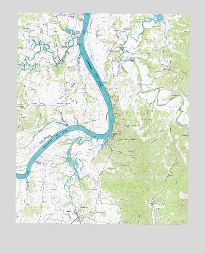
Hookers Bend, TN USGS Topographic Map
Click on map above to begin viewing in our Map Viewer.

This topographic map contains these locations and features:
Feature Name Type Latitude Longitude GNIS ID View Map
Aenon CemeteryCemeteryN35.2934°W88.1684°1275498View Map
Alexander BranchStreamN35.3098°W88.1400°1275546View Map
Anderson BranchStreamN35.3562°W88.2339°1275689View Map
Anderson CemeteryCemeteryN35.3670°W88.2356°1275697View Map
Antioch School (historical)SchoolN35.3204°W88.2164°1323719View Map
Bayse CemeteryCemeteryN35.2723°W88.2073°1276522View Map
Beasley CemeteryCemeteryN35.3192°W88.1328°1323725View Map
Bell BranchStreamN35.3267°W88.1481°1276900View Map
Berlin SchoolSchoolN35.2562°W88.1925°1277042View Map
Blue Spring BranchStreamN35.2620°W88.2111°1277796View Map
Boiling Springs CemeteryCemeteryN35.3706°W88.2064°1323736View Map
Boiling Springs CemeteryCemeteryN35.3706°W88.2078°1323737View Map
Breckenridge CemeteryCemeteryN35.2654°W88.2006°1323742View Map
Brown CornersLocaleN35.3523°W88.1809°1278570View Map
BucktownPopulated PlaceN35.2701°W88.1950°1278890View Map
Cagle BranchStreamN35.3334°W88.1606°1279283View Map
Callens BranchStreamN35.3473°W88.1753°1279334View Map
Canning Factory BranchStreamN35.3090°W88.2131°1279602View Map
Carter CemeteryCemeteryN35.3731°W88.2409°1323752View Map
Cawthon CemeteryCemeteryN35.3403°W88.2331°1279980View Map
CenterviewPopulated PlaceN35.2854°W88.1736°1280153View Map
Cerro GordoPopulated PlaceN35.3037°W88.1806°1305836View Map
Cerro Gordo Elementary SchoolSchoolN35.3079°W88.1661°1648270View Map
Cerro Gordo Ferry (historical)CrossingN35.3020°W88.1853°1313249View Map
Cerro Gordo LandingLocaleN35.3015°W88.1825°1323755View Map
Clemmitt BranchValleyN35.2556°W88.1511°1280698View Map
Collins LandingLocaleN35.3326°W88.1873°1646317View Map
Commissioner District 8CivilN35.2643°W88.2379°2464677View Map
Cravens Ferry (historical)CrossingN35.3073°W88.2048°1313252View Map
Cravens LandingLocaleN35.3056°W88.2048°1314907View Map
Cypress Pond SloughStreamN35.3076°W88.2125°1281945View Map
Cypress SloughStreamN35.3620°W88.2020°1281946View Map
Davis IslandIslandN35.3476°W88.1653°1282191View Map
Davis LagoonStreamN35.3481°W88.1659°1282194View Map
Dickey LandingLocaleN35.3045°W88.1950°1314946View Map
District 2 (historical)CivilN35.3626°W88.1625°1310165View Map
Doran SloughStreamN35.3015°W88.2248°1282649View Map
Duke BranchStreamN35.3309°W88.1473°1283108View Map
Farmers Union LandingLocaleN35.3631°W88.2048°1284144View Map
Filgo BranchStreamN35.3456°W88.1761°1284254View Map
Flat BluffCliffN35.3159°W88.1806°1284362View Map
Goshen CemeteryCemeteryN35.3403°W88.1453°1285714View Map
Haislip BranchStreamN35.3340°W88.2028°1286503View Map
Hamilton CemeteryCemeteryN35.2720°W88.2334°1323805View Map
Hardin BranchStreamN35.2973°W88.1856°1286814View Map
Hardin CemeteryCemeteryN35.2834°W88.1778°1323812View Map
Hardin County Fire Department / Emergency Management District 1 Station 2BuildingN35.3206°W88.2398°2654248View Map
Hardin County Fire Department / Emergency Management District 4 Station 1BuildingN35.3074°W88.1654°2654245View Map
Hardin County Fire Department / Emergency Management District 4 Station 2BuildingN35.3453°W88.1406°2654088View Map
Hardin County Fire Department / Emergency Management District 5 Station 1BuildingN35.2558°W88.1979°2654086View Map
Hardin Creek Ferry (historical)CrossingN35.3026°W88.1939°1313261View Map
Hobbs Mill BranchStreamN35.3017°W88.1831°1287938View Map
Holts LandingLocaleN35.2790°W88.2464°1323828View Map
HoltsvillePopulated PlaceN35.3123°W88.2475°1288176View Map
Hookers BendBendN35.3206°W88.2023°1288237View Map
Hookers BendPopulated PlaceN35.3206°W88.2153°1288238View Map
Horse CreekStreamN35.3012°W88.1942°1288394View Map
Huey BluffCliffN35.3265°W88.1348°1288630View Map
Isaac Reed CemeteryCemeteryN35.2670°W88.1761°1323838View Map
Lee CemeteryCemeteryN35.3109°W88.1953°1290944View Map
Liberty-Davis CemeteryCemeteryN35.2909°W88.1673°1323851View Map
Lick BranchStreamN35.2806°W88.2061°1306686View Map
Lindsey CemeteryCemeteryN35.3420°W88.1492°1323853View Map
Love BluffCliffN35.3309°W88.1484°1292113View Map
Love BranchStreamN35.3176°W88.1303°1292115View Map
Lower BridgeBridgeN35.3542°W88.1748°1292210View Map
Maple Slash SloughStreamN35.3504°W88.2036°1292629View Map
Martin CemeteryCemeteryN35.2998°W88.1425°1323858View Map
Mary Jane BluffCliffN35.3487°W88.1675°1292863View Map
Mays Ferry (historical)CrossingN35.2784°W88.2431°1313268View Map
McCasland CemeteryCemeteryN35.3034°W88.1253°1293134View Map
Middle BridgeBridgeN35.3329°W88.1603°1293651View Map
Middle Bridge East CemeteryCemeteryN35.3309°W88.1536°1323862View Map
Middle Bridge West CemeteryCemeteryN35.3328°W88.1614°1323863View Map
Miles CreekStreamN35.3604°W88.2086°1293776View Map
Miller SloughStreamN35.2770°W88.2425°1293966View Map
Morris CemeteryCemeteryN35.2731°W88.1800°1323865View Map
Mount Herman CemeteryCemeteryN35.2520°W88.1745°1323872View Map
Mount Herman ChurchChurchN35.2512°W88.1750°1294631View Map
New HarmonyPopulated PlaceN35.3126°W88.1581°1315588View Map
New Harmony Baptist ChurchChurchN35.3123°W88.1578°1323877View Map
New Harmony CemeteryCemeteryN35.3112°W88.1581°1323878View Map
New Prospect CemeteryCemeteryN35.3181°W88.2445°1323880View Map
New Prospect ChurchChurchN35.3179°W88.2453°1295617View Map
New Russell Chapel CemeteryCemeteryN35.3659°W88.1728°1323881View Map
Oak GrovePopulated PlaceN35.2745°W88.2298°1296054View Map
Oak Grove School (historical)SchoolN35.2659°W88.2289°1323887View Map
Oakland CemeteryCemeteryN35.3298°W88.2167°1323888View Map
Oakland ChurchChurchN35.3295°W88.2153°1296181View Map
Old Russell Chapel CemeteryCemeteryN35.3662°W88.1714°1323890View Map
Orr BranchStreamN35.3442°W88.2217°1296494View Map
Owen CemeteryCemeteryN35.3412°W88.1445°1323895View Map
Paulks (historical)Populated PlaceN35.2570°W88.1925°1313272View Map
Paulks Mill BridgeBridgeN35.2540°W88.2045°1296993View Map
Petticoat RifflesBarN35.3412°W88.1953°1313273View Map
Pitts BendBendN35.3695°W88.1789°1297752View Map
Polk CemeteryCemeteryN35.3323°W88.1714°1298057View Map
Polks LandingLocaleN35.3381°W88.1909°1323911View Map
Pony CreekStreamN35.3729°W88.1456°1298126View Map
Reynolds CemeteryCemeteryN35.3501°W88.1586°1299250View Map
Robinson ChapelChurchN35.2567°W88.1920°1299698View Map
Robinsons Chapel CemeteryCemeteryN35.2562°W88.1923°1323918View Map
Robinsons School (historical)SchoolN35.2562°W88.1939°1323919View Map
Russell ChapelChurchN35.3659°W88.1731°1300323View Map
Saint Johns School (historical)SchoolN35.2731°W88.2231°1323925View Map
Saint Pauls ChurchChurchN35.3290°W88.2370°1300505View Map
Saltillo FerryCrossingN35.3737°W88.1995°1313278View Map
Sandford BranchStreamN35.3456°W88.1759°1300714View Map
Sawmill BranchStreamN35.3004°W88.1864°1300828View Map
Shady Hill BranchStreamN35.3565°W88.1417°1301190View Map
Shady Hill CemeteryCemeteryN35.3534°W88.1456°1323943View Map
Shady Hill ChurchChurchN35.3526°W88.1453°1301191View Map
Shannons LandingLocaleN35.3745°W88.2014°1323944View Map
Shiloh CemeteryCemeteryN35.3503°W88.1342°1323946View Map
Smith CemeteryCemeteryN35.3506°W88.1811°1270597View Map
Stanfield BranchStreamN35.3229°W88.1520°1271229View Map
Stanfield BranchStreamN35.3534°W88.1378°1271230View Map
StringtownPopulated PlaceN35.3640°W88.1761°1314347View Map
Sulphur BranchStreamN35.3565°W88.2342°1271768View Map
Sulphur WellLocaleN35.3645°W88.2417°1271824View Map
Sulphur Well SpringSpringN35.3600°W88.2413°1271825View Map
Sweetwater BranchStreamN35.3676°W88.1423°1271982View Map
SwiftPopulated PlaceN35.3440°W88.1411°1271986View Map
Swift School (historical)SchoolN35.3492°W88.1470°1323958View Map
Tall CemeteryCemeteryN35.3126°W88.2467°1323960View Map
Tarbet CemeteryCemeteryN35.3637°W88.2242°1272123View Map
Thacker BranchStreamN35.3270°W88.1306°1272355View Map
The ForkCapeN35.2773°W88.2284°1272390View Map
Thompson BranchStreamN35.3437°W88.1559°1272503View Map
Turner BranchStreamN35.3012°W88.1381°1273060View Map
Union Grove ChurchChurchN35.3692°W88.2270°1273223View Map
Union SchoolSchoolN35.3204°W88.2395°1273249View Map
Upper BridgeBridgeN35.3070°W88.1253°1323969View Map
Walker BranchStreamN35.3634°W88.1598°1273560View Map
Welch BranchStreamN35.3065°W88.2311°1274063View Map
Welles LandingLocaleN35.3181°W88.1809°1323983View Map
Wells CemeteryCemeteryN35.3167°W88.1773°1323984View Map
White Oak BridgeBridgeN35.3467°W88.2186°1274389View Map
White Oak CreekStreamN35.3562°W88.2064°1304526View Map
Whitlow BranchStreamN35.3187°W88.1323°1304566View Map
Whitlow CemeteryCemeteryN35.3115°W88.1356°1323992View Map
WKWX-FM (Savannah)TowerN35.2856°W88.1675°1640042View Map
Yokum CemeteryCemeteryN35.3020°W88.1811°1323996View Map

Note: Coordinates in the location and feature list above are referenced to NAD83 datum.


Copyright (C) 2008-2024 Ryan Niemi / Sunset Dynamics ... All Rights Reserved