TopoQuest Logo
Do you find TopoQuest useful?
Help keep TopoQuest running and adding new maps/features by donating!
Bitcoin:  19c7KJd3qBynnjoSw5npx9KScwjBe4ifkT
Litecoin:  LXs6TkuXGGXo1vDsWCkWVdjQX94eUKd6ui
Home View Maps Find Maps Find Places Resources & Links


Wolf Pit Ridge, Tennessee Topographic Map

USGS Map Title: Wolf Pit Ridge, TN
USGS Map MRC: 35088B1
DRG (GeoTIFF) Download: o35088b1.tif


Neighboring USGS Topographic Map Quads:


  Hookers Bend, TN  
35088C2
 

  Olivehill, TN  
35088C1
 

  Eagle Creek, TN  
35087C8
 

  Savannah, TN  
35088B2
 

  Wolf Pit Ridge, TN  
35088B1
 

  Martins Mills, TN  
35087B8
 

  Pickwick, TN  
35088A2
 

  Lowryville, TN  
35088A1
 

  Ransom Stand, TN  
35087A8


Map MRC Location:

N36°
W89°
N36°
W88°
H8 H7 H6 H5 H4 H3 H2 H1
G8 G7 G6 G5 G4 G3 G2 G1
F8 F7 F6 F5 F4 F3 F2 F1
E8 E7 E6 E5 E4 E3 E2 E1
D8 D7 D6 D5 D4 D3 D2 D1
C8 C7 C6 C5 C4 C3 C2 C1
B8 B7 B6 B5 B4 B3 B2 B1
A8 A7 A6 A5 A4 A3 A2 A1
N35°
W89°
N35°
W88°

Wolf Pit Ridge, TN USGS 1:24K Topographic Map Preview:
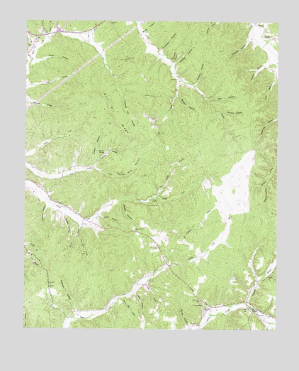
Wolf Pit Ridge, TN USGS Topographic Map
Click on map above to begin viewing in our Map Viewer.

This topographic map contains these locations and features:
Feature Name Type Latitude Longitude GNIS ID View Map
Abrams ChapelChurchN35.1317°W88.0103°1304757View Map
Alder Grove School (historical)SchoolN35.1795°W88.1050°1323716View Map
Baugus BranchStreamN35.1901°W88.0914°1276496View Map
Baugus HollowValleyN35.2197°W88.0503°1276499View Map
Baugus SpringSpringN35.1965°W88.0861°1303420View Map
Boon CemeteryCemeteryN35.2395°W88.1236°1277974View Map
Brady BranchStreamN35.2292°W88.0536°1278203View Map
Bratton CemeteryCemeteryN35.1454°W88.0195°1278253View Map
Bratton HollowValleyN35.2240°W88.0407°1305401View Map
Brooks CemeteryCemeteryN35.1331°W88.0306°1323744View Map
Cashion HollowValleyN35.1748°W88.1137°1279852View Map
Center StarPopulated PlaceN35.1645°W88.0700°1314814View Map
Center Star School (historical)SchoolN35.1645°W88.0686°1323754View Map
Cook HollowValleyN35.2283°W88.0006°1281121View Map
Copeland BranchStreamN35.1517°W88.0523°1281237View Map
Crawford HollowValleyN35.2430°W88.0143°1281582View Map
Davis BranchStreamN35.2409°W88.0948°1282131View Map
Davis HollowValleyN35.1397°W88.0701°1282183View Map
Dickson CemeteryCemeteryN35.1717°W88.1117°1323777View Map
District 5 (historical)CivilN35.1917°W88.0250°1310168View Map
Dudley HollowValleyN35.1720°W88.1056°1283065View Map
Duncan HollowValleyN35.1847°W88.0058°1283163View Map
Franks CemeteryCemeteryN35.1462°W88.0042°1284837View Map
Franks CemeteryCemeteryN35.1456°W88.0534°1323794View Map
George HollowValleyN35.1768°W88.0784°1285302View Map
Germany BranchStreamN35.1362°W88.0148°1285321View Map
Gillis CemeteryCemeteryN35.1334°W88.0131°1285419View Map
Gillis SchoolSchoolN35.1315°W88.0095°1285421View Map
Gillises MillsPopulated PlaceN35.1356°W88.0353°1315113View Map
Gobbler BranchStreamN35.1790°W88.0598°1285551View Map
Godwin BranchStreamN35.2331°W88.1234°1285565View Map
Godwin Mill HollowValleyN35.2218°W88.0776°1285569View Map
Hames CemeteryCemeteryN35.2492°W88.0836°1323804View Map
Harbert Hills AcademySchoolN35.2112°W88.0645°1286791View Map
Harbour CemeteryCemeteryN35.2390°W88.0106°1323808View Map
Hardin County Fire Department / Emergency Management District 9 Station 2BuildingN35.2080°W88.0631°2654241View Map
Hendrix HollowValleyN35.2132°W88.0281°1287409View Map
Jack HollowValleyN35.2175°W88.0343°1289152View Map
Jerrold CemeteryCemeteryN35.2429°W88.1200°1323839View Map
Jerrolds BranchStreamN35.2376°W88.1211°1269691View Map
King CemeteryCemeteryN35.1426°W88.0728°1323845View Map
Lacefield CemeteryCemeteryN35.2245°W88.0475°1323846View Map
Lacefield CemeteryCemeteryN35.2265°W88.0497°1290438View Map
Martin HollowValleyN35.2331°W88.0036°1292838View Map
McClarin HollowValleyN35.1307°W88.0997°1293152View Map
McLaren CemeteryCemeteryN35.1315°W88.0981°1323861View Map
Mitchell BranchStreamN35.1673°W88.0984°1294095View Map
Mozier Mill HollowValleyN35.1901°W88.0904°1269823View Map
Nichols BranchStreamN35.1279°W88.0017°1295719View Map
Petty BranchStreamN35.1431°W88.0686°1297268View Map
Pickens CemeteryCemeteryN35.1445°W88.0634°1297388View Map
Poplar Flat BranchStreamN35.1376°W88.0773°1298187View Map
Porter Mill BranchStreamN35.1629°W88.0981°1298267View Map
Puncheon HollowValleyN35.2343°W88.0529°1298698View Map
Rainey HollowValleyN35.1260°W88.0437°1298839View Map
Rocky BranchStreamN35.2423°W88.1150°1299872View Map
Sambo BranchStreamN35.1709°W88.0892°1300629View Map
Smith BranchStreamN35.2340°W88.1223°1313283View Map
Smith CemeteryCemeteryN35.2356°W88.0756°1270591View Map
Smith CemeteryCemeteryN35.1898°W88.1050°1323949View Map
Smith HollowValleyN35.2338°W88.1204°1270678View Map
Smith-Rose CemeteryCemeteryN35.2154°W88.0550°1323950View Map
Stricklin CemeteryCemeteryN35.1326°W88.1006°1323956View Map
Sunny Hill CemeteryCemeteryN35.1340°W88.0339°1271860View Map
Sutton HollowValleyN35.1937°W88.0892°1271907View Map
Tilley CemeteryCemeteryN35.1920°W88.0731°1323962View Map
Union Chapel School (historical)SchoolN35.2490°W88.0828°1323967View Map
Vanbibber HollowValleyN35.2379°W88.0579°1273362View Map
Vanbidder CemeteryCemeteryN35.2356°W88.0584°1323970View Map
WDNX-FM (Olive Hill)TowerN35.2084°W88.0628°1640035View Map
Welch CemeteryCemeteryN35.1445°W88.0709°1323982View Map
White HollowValleyN35.2453°W88.0670°1274379View Map
Wildcat HollowValleyN35.1314°W88.0248°1313294View Map
Wildcat HollowValleyN35.2332°W88.0519°1274536View Map
Wilkerson CemeteryCemeteryN35.1826°W88.0586°1323993View Map
Wilkerson CemeteryCemeteryN35.1870°W88.0664°1323994View Map
Wilkerson CemeteryCemeteryN35.1748°W88.0600°1304593View Map
Wilson BranchStreamN35.2448°W88.1145°1274794View Map
Wolf Pit RidgeRidgeN35.2106°W88.0817°1274973View Map

Note: Coordinates in the location and feature list above are referenced to NAD83 datum.


Copyright (C) 2008-2024 Ryan Niemi / Sunset Dynamics ... All Rights Reserved