TopoQuest Logo
Do you find TopoQuest useful?
Help keep TopoQuest running and adding new maps/features by donating!
Bitcoin:  19c7KJd3qBynnjoSw5npx9KScwjBe4ifkT
Litecoin:  LXs6TkuXGGXo1vDsWCkWVdjQX94eUKd6ui
Home View Maps Find Maps Find Places Resources & Links


Olivehill, Tennessee Topographic Map

USGS Map Title: Olivehill, TN
USGS Map MRC: 35088C1
DRG (GeoTIFF) Download: o35088c1.tif


Neighboring USGS Topographic Map Quads:


  Thurman, TN  
35088D2
 

  Bath Springs, TN  
35088D1
 

  Clifton, TN  
35087D8
 

  Hookers Bend, TN  
35088C2
 

  Olivehill, TN  
35088C1
 

  Eagle Creek, TN  
35087C8
 

  Savannah, TN  
35088B2
 

  Wolf Pit Ridge, TN  
35088B1
 

  Martins Mills, TN  
35087B8


Map MRC Location:

N36°
W89°
N36°
W88°
H8 H7 H6 H5 H4 H3 H2 H1
G8 G7 G6 G5 G4 G3 G2 G1
F8 F7 F6 F5 F4 F3 F2 F1
E8 E7 E6 E5 E4 E3 E2 E1
D8 D7 D6 D5 D4 D3 D2 D1
C8 C7 C6 C5 C4 C3 C2 C1
B8 B7 B6 B5 B4 B3 B2 B1
A8 A7 A6 A5 A4 A3 A2 A1
N35°
W89°
N35°
W88°

Olivehill, TN USGS 1:24K Topographic Map Preview:
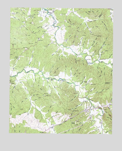
Olivehill, TN USGS Topographic Map
Click on map above to begin viewing in our Map Viewer.

This topographic map contains these locations and features:
Feature Name Type Latitude Longitude GNIS ID View Map
Akins BranchStreamN35.3295°W88.0373°1275519View Map
Altum Spring CemeteryCemeteryN35.3665°W88.0884°1323717View Map
Arch BridgeBridgeN35.2773°W88.0217°1275838View Map
Ashworth HollowValleyN35.3075°W88.0498°1275954View Map
Backbone RidgeRidgeN35.3679°W88.0264°1269309View Map
Bailey CemeteryCemeteryN35.2587°W88.0734°1276098View Map
Bailey CemeteryCemeteryN35.2898°W88.0459°1323721View Map
Bailey IslandIslandN35.2912°W88.0411°1276113View Map
Banks HollowValleyN35.3356°W88.0660°1276266View Map
Baugus BranchStreamN35.2801°W88.0984°1304997View Map
Baxter HollowValleyN35.2998°W88.1161°1276513View Map
Bear BranchStreamN35.3587°W88.0714°1276552View Map
Bear BranchStreamN35.2734°W88.0117°1276565View Map
Beckham CemeteryCemeteryN35.3170°W88.0228°1323726View Map
Beckham HollowValleyN35.3199°W88.0216°1276743View Map
Bee HollowValleyN35.3384°W88.0110°1276774View Map
Berry BranchStreamN35.3712°W88.0784°1277049View Map
BethlehemPopulated PlaceN35.3017°W88.0325°1314673View Map
Bethlehem CemeteryCemeteryN35.3012°W88.0320°1323730View Map
Bethlehem School (historical)SchoolN35.3020°W88.0311°1323731View Map
Bigbee BranchStreamN35.2790°W88.0248°1277441View Map
Blackshire RidgeRidgeN35.3606°W88.0495°1277616View Map
Boat Gunwale HollowValleyN35.3637°W88.0180°1277853View Map
Bolden SpringSpringN35.3657°W88.0992°1277895View Map
Boneyard HollowValleyN35.3075°W88.0878°1277946View Map
Bowling BranchStreamN35.3104°W88.0850°1278058View Map
Bowling CemeteryCemeteryN35.3206°W88.0750°1323739View Map
Brashier BranchStreamN35.3237°W88.0186°1278245View Map
Brashier CemeteryCemeteryN35.3245°W88.0189°1323741View Map
Bratten HollowValleyN35.2891°W88.0288°1278250View Map
Brooks CemeteryCemeteryN35.3223°W88.0922°1323743View Map
Bryant FordCrossingN35.2604°W88.0128°1313244View Map
Bumpas CemeteryCemeteryN35.3345°W88.1014°1323748View Map
Buzzard Cave HollowValleyN35.3333°W88.0296°1279216View Map
Caney HollowValleyN35.3076°W88.0715°1279580View Map
Cave SpringSpringN35.3567°W88.0557°1279945View Map
Christian HollowValleyN35.3274°W88.0262°1280524View Map
Clark FordCrossingN35.3359°W88.0561°1313251View Map
Clausel HollowValleyN35.2769°W88.1224°1280618View Map
Commissioner District 6CivilN35.2988°W88.0900°2464538View Map
Connelly CemeteryCemeteryN35.3731°W88.1203°1281092View Map
Copperas SpringSpringN35.2876°W88.0802°1281275View Map
CrossroadsPopulated PlaceN35.2998°W88.1236°1314913View Map
Crossroads School (historical)SchoolN35.2995°W88.1236°1323769View Map
CrowtexasPopulated PlaceN35.2745°W88.1120°1314916View Map
Dark HollowValleyN35.3042°W88.0448°1282041View Map
Davis CemeteryCemeteryN35.3378°W88.0339°1323773View Map
Davis CemeteryCemeteryN35.3287°W88.0267°1323774View Map
Davis HollowValleyN35.2852°W88.1020°1282184View Map
Davis HollowValleyN35.3184°W88.0102°1282185View Map
Davis IslandIslandN35.3237°W88.0286°1282190View Map
Day HollowValleyN35.2819°W88.0370°1282219View Map
Day SpringSpringN35.2739°W88.0540°1282224View Map
Dick Hardin CemeteryCemeteryN35.3028°W88.0806°1323775View Map
Dickey CemeteryCemeteryN35.2706°W88.0939°1323776View Map
Dickson BluffCliffN35.2845°W88.0273°1282452View Map
Dillon Farm CemeteryCemeteryN35.3292°W88.0092°1641786View Map
District 1 (historical)CivilN35.3501°W88.0375°1310164View Map
District 14 (historical)CivilN35.2931°W88.0750°1310177View Map
Dowdy HollowValleyN35.3629°W88.0325°1282758View Map
Dowdy SpringSpringN35.3714°W88.0277°1282759View Map
Duckworth HollowValleyN35.3078°W88.0506°1283056View Map
Duncan Pond (historical)LakeN35.3609°W88.0570°1313256View Map
Eagle CreekStreamN35.3187°W88.0003°1283289View Map
Flat GapGapN35.2754°W88.0111°1284390View Map
Flat Gap CreekStreamN35.2845°W88.0286°1284398View Map
Forge RidgeRidgeN35.2762°W88.0148°1284612View Map
Franklin BranchStreamN35.2865°W88.0320°1284817View Map
Franks CemeteryCemeteryN35.2620°W88.0472°1323793View Map
Gant HollowValleyN35.2690°W88.0820°1285135View Map
Garrard Cave SpringSpringN35.3028°W88.0592°1285182View Map
Garrard FordCrossingN35.3037°W88.0595°1315096View Map
Garrard Spring CemeteryCemeteryN35.3020°W88.0628°1323798View Map
Gillham HollowValleyN35.3398°W88.0622°1285405View Map
Gilmore CemeteryCemeteryN35.2787°W88.0120°1323799View Map
Gilmore HollowValleyN35.2872°W88.0310°1285433View Map
Gravel PitRidgeN35.3506°W88.0361°1285934View Map
Gravett BranchStreamN35.2709°W88.1014°1285970View Map
Gray HollowValleyN35.3624°W88.0343°1286004View Map
Hamilton HollowValleyN35.3243°W88.0169°1286661View Map
Hannah Church (historical)ChurchN35.3640°W88.1078°1323806View Map
Hannah HollowValleyN35.3606°W88.1114°1286745View Map
Hannah SinkBasinN35.3601°W88.1020°1286748View Map
Harbour CemeteryCemeteryN35.2529°W88.0084°1323809View Map
Hardin BranchStreamN35.2856°W88.0373°1286813View Map
Hardin BranchStreamN35.3098°W88.0953°1286815View Map
Hardin CemeteryCemeteryN35.3362°W88.0370°1323810View Map
Hardin CemeteryCemeteryN35.3712°W88.0547°1323811View Map
Hardin CemeteryCemeteryN35.3009°W88.0981°1323813View Map
Hardin County Fire Department / Emergency Management District 4 Station 3BuildingN35.3343°W88.1056°2654087View Map
Hardin County Fire Department / Emergency Management District 9 Station 1BuildingN35.2735°W88.0328°2654242View Map
Hardin County Fire Department / Emergency Management District 9 Station 3BuildingN35.2736°W88.0289°2654041View Map
Hardin FordCrossingN35.3051°W88.0778°1315188View Map
Hardin School (historical)SchoolN35.3398°W88.0545°1323819View Map
Hardin SpringSpringN35.2823°W88.0350°1286835View Map
Hardin SpringSpringN35.3432°W88.0903°1286836View Map
HavanaPopulated PlaceN35.3670°W88.0989°1315205View Map
Havana School (historical)SchoolN35.3673°W88.1020°1323823View Map
Havanna CemeteryCemeteryN35.3673°W88.1014°1652249View Map
Havanna ChurchChurchN35.3673°W88.1003°1323822View Map
Henry Hardin HollowValleyN35.3619°W88.0331°1287448View Map
Hogpen HollowValleyN35.3274°W88.0370°1313262View Map
Hosey HollowValleyN35.3718°W88.0889°1288467View Map
Howe CemeteryCemeteryN35.3195°W88.1147°1323832View Map
Hudiburg FordCrossingN35.2862°W88.0300°1313263View Map
Hudiburg SpringSpringN35.2992°W88.0263°1288614View Map
Hughes HollowValleyN35.2611°W88.0335°1288678View Map
Hulen CemeteryCemeteryN35.3434°W88.1100°1323833View Map
Hulin BranchStreamN35.3048°W88.0764°1288686View Map
Jeff HollowValleyN35.3110°W88.0583°1289321View Map
Jerrolds CemeteryCemeteryN35.2615°W88.0492°1323840View Map
Joe HollowValleyN35.2805°W88.0014°1289469View Map
Johnson FordCrossingN35.3729°W88.0798°1315302View Map
Jordan HollowValleyN35.2613°W88.0361°1289839View Map
Jowers CemeteryCemeteryN35.2634°W88.0428°1289858View Map
Kincannon CemeteryCemeteryN35.2845°W88.0978°1323844View Map
King HollowValleyN35.3368°W88.0260°1290220View Map
Linville FordCrossingN35.2548°W88.0117°1313267View Map
Looney CemeteryCemeteryN35.2587°W88.1200°1323854View Map
Lovefield BranchStreamN35.3051°W88.0820°1292133View Map
Mag HollowValleyN35.2868°W88.0985°1292492View Map
Marshall HollowValleyN35.2642°W88.0780°1292771View Map
Mash HollowValleyN35.3390°W88.1038°1292873View Map
McCasland BranchStreamN35.3137°W88.1081°1293133View Map
McCasland CemeteryCemeteryN35.3226°W88.0992°1323859View Map
McCollum HollowValleyN35.3550°W88.0878°1293176View Map
Mill HollowValleyN35.3015°W88.0944°1293866View Map
Mill Hollow CemeteryCemeteryN35.2995°W88.0900°1323864View Map
Morris HollowValleyN35.2813°W88.0955°1294432View Map
Mount Carmel CemeteryCemeteryN35.3684°W88.0620°1323871View Map
Mount Carmel ChurchChurchN35.3690°W88.0617°1294577View Map
Mountain View CemeteryCemeteryN35.3342°W88.1045°1323873View Map
Mountain View ChurchChurchN35.3340°W88.1039°1323874View Map
Mountain View School (historical)SchoolN35.3340°W88.1036°1323875View Map
Northcut ElementaryCemeteryN35.2529°W88.0172°1323885View Map
Northcutt BranchStreamN35.2581°W88.0128°1295954View Map
Norton HollowValleyN35.3343°W88.0419°1295987View Map
Old CemeteryCemeteryN35.3190°W88.0125°1641868View Map
Olive Hill Baptist ChurchChurchN35.2731°W88.0331°1323892View Map
Olive Hill CemeteryCemeteryN35.2728°W88.0325°1323893View Map
Olive Hill Division (historical)CensusN35.2717°W88.1156°1648753View Map
Olive Hill School (historical)SchoolN35.2737°W88.0298°1323894View Map
OlivehillPopulated PlaceN35.2740°W88.0323°1296412View Map
Owl HollowValleyN35.3547°W88.0279°1296597View Map
Panther BranchStreamN35.2795°W88.0064°1296726View Map
Paradise HollowValleyN35.2963°W88.0362°1296756View Map
Patterson CemeteryCemeteryN35.2637°W88.0250°1296937View Map
Perry Chapel (historical)ChurchN35.3390°W88.0353°1323898View Map
Pine Knob RidgeRidgeN35.3484°W88.0992°1297558View Map
Piney GrovePopulated PlaceN35.2898°W88.0756°1315720View Map
Piney Grove CemeteryCemeteryN35.2881°W88.0831°1323905View Map
Piney Grove ChurchChurchN35.2881°W88.0820°1323906View Map
Pitts HollowValleyN35.3325°W88.0605°1297764View Map
Pogue CemeteryCemeteryN35.2990°W88.1245°1323910View Map
Polk HollowValleyN35.3240°W88.0372°1298060View Map
Pool HollowValleyN35.3569°W88.1109°1298127View Map
Porter FordCrossingN35.3204°W88.0298°1315768View Map
Pulley BranchStreamN35.3573°W88.0753°1298662View Map
Reynolds BranchStreamN35.2751°W88.0459°1299246View Map
Reynolds SpringSpringN35.2730°W88.0464°1299263View Map
Rocky BranchStreamN35.3409°W88.0689°1299849View Map
Rose BranchStreamN35.3367°W88.0595°1300063View Map
Rose HollowValleyN35.3377°W88.0474°1300083View Map
Rose School (historical)SchoolN35.3554°W88.0589°1323921View Map
Russ CoalingsSummitN35.3484°W88.0273°1300297View Map
Sandy Bottom IslandIslandN35.3034°W88.0736°1300731View Map
Schoolhouse HollowValleyN35.3371°W88.0538°1313281View Map
Simmons BranchStreamN35.2987°W88.0445°1270289View Map
Sims FordCrossingN35.3292°W88.0436°1314295View Map
Sims HollowValleyN35.3276°W88.0442°1270355View Map
Sims SpringSpringN35.3227°W88.0445°1270357View Map
Smith ForkStreamN35.3062°W88.1186°1303679View Map
Smiths Fork (historical)Populated PlaceN35.2570°W88.0723°1313284View Map
Spear HollowValleyN35.3240°W88.0049°1270965View Map
Steward CemeteryCemeteryN35.2970°W88.0984°1646828View Map
Stricklin HollowValleyN35.2507°W88.0074°1271594View Map
Tanyard HollowValleyN35.2569°W88.0733°1272108View Map
Thacker CemeteryCemeteryN35.3251°W88.1034°1323961View Map
Thompson CrossroadsPopulated PlaceN35.2620°W88.0492°1314394View Map
Ticey HollowValleyN35.3716°W88.0495°1272613View Map
Turkey HollowValleyN35.2884°W88.0418°1273019View Map
Umphreys CemeteryCemeteryN35.2909°W88.0792°1323965View Map
Union ChapelLocaleN35.2512°W88.0823°1273196View Map
Union Chapel North CemeteryCemeteryN35.2517°W88.0836°1323966View Map
Wad Hardin HollowValleyN35.3343°W88.0351°1273511View Map
Walker HollowValleyN35.3303°W88.0147°1273626View Map
Walker RidgeRidgeN35.3109°W88.0139°1273642View Map
Watson CemeteryCemeteryN35.3367°W88.0820°1304416View Map
White CemeteryCemeteryN35.2751°W88.0095°1323989View Map
Whitten FordCrossingN35.2862°W88.0331°1313292View Map
Yarbrough HollowValleyN35.2989°W88.0391°1275238View Map

Note: Coordinates in the location and feature list above are referenced to NAD83 datum.


Copyright (C) 2008-2024 Ryan Niemi / Sunset Dynamics ... All Rights Reserved