TopoQuest Logo
Do you find TopoQuest useful?
Help keep TopoQuest running and adding new maps/features by donating!
Bitcoin:  19c7KJd3qBynnjoSw5npx9KScwjBe4ifkT
Litecoin:  LXs6TkuXGGXo1vDsWCkWVdjQX94eUKd6ui
Home View Maps Find Maps Find Places Resources & Links


Bath Springs, Tennessee Topographic Map

USGS Map Title: Bath Springs, TN
USGS Map MRC: 35088D1
DRG (GeoTIFF) Download: o35088d1.tif


Neighboring USGS Topographic Map Quads:


  Scotts Hill, TN  
35088E2
 

  Perryville, TN  
35088E1
 

  Pope, TN  
35087E8
 

  Thurman, TN  
35088D2
 

  Bath Springs, TN  
35088D1
 

  Clifton, TN  
35087D8
 

  Hookers Bend, TN  
35088C2
 

  Olivehill, TN  
35088C1
 

  Eagle Creek, TN  
35087C8


Map MRC Location:

N36°
W89°
N36°
W88°
H8 H7 H6 H5 H4 H3 H2 H1
G8 G7 G6 G5 G4 G3 G2 G1
F8 F7 F6 F5 F4 F3 F2 F1
E8 E7 E6 E5 E4 E3 E2 E1
D8 D7 D6 D5 D4 D3 D2 D1
C8 C7 C6 C5 C4 C3 C2 C1
B8 B7 B6 B5 B4 B3 B2 B1
A8 A7 A6 A5 A4 A3 A2 A1
N35°
W89°
N35°
W88°

Bath Springs, TN USGS 1:24K Topographic Map Preview:
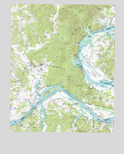
Bath Springs, TN USGS Topographic Map
Click on map above to begin viewing in our Map Viewer.

This topographic map contains these locations and features:
Feature Name Type Latitude Longitude GNIS ID View Map
Akin LandingLocaleN35.4417°W88.0420°1314568View Map
Altom BranchStreamN35.3756°W88.0859°1275643View Map
Backbone Ridge CemeteryCemeteryN35.3773°W88.0464°1323720View Map
Bailey CemeteryCemeteryN35.4906°W88.0753°1276099View Map
Baker CemeteryCemeteryN35.3784°W88.0225°1276149View Map
Bath SpringsPopulated PlaceN35.4398°W88.0878°1276470View Map
Bath Springs Baptist ChurchChurchN35.4412°W88.0911°1644646View Map
Blue SpringSpringN35.4320°W88.0059°1277779View Map
Bobs BranchStreamN35.4431°W88.0431°1277867View Map
Bobs LandingLocaleN35.4481°W88.0448°1314710View Map
Borough Ford (historical)CrossingN35.3854°W88.0859°1313242View Map
Buckeys LandingLocaleN35.4745°W88.0245°1644654View Map
Buffalo ShoalsBarN35.4240°W88.0245°1642897View Map
Butler BranchStreamN35.4587°W88.1236°1269407View Map
Campbell BranchStreamN35.4001°W88.0981°1279419View Map
Cave HollowValleyN35.3858°W88.0864°1279932View Map
Center Camp GroundLocaleN35.4690°W88.0981°1316725View Map
Center ChurchChurchN35.4681°W88.1000°1305801View Map
Center School (historical)SchoolN35.4684°W88.0995°1316726View Map
Channell CemeteryCemeteryN35.4403°W88.0797°1280243View Map
Clifton BendBendN35.4087°W88.0120°1280727View Map
Clifton CemeteryCemeteryN35.3803°W88.0011°1280728View Map
Clifton MarinaLocaleN35.3856°W88.0070°1317750View Map
Commissioner District 1CivilN35.4579°W88.0933°2464225View Map
Connelly BranchStreamN35.3829°W88.1195°1281091View Map
Culp CemeteryCemeteryN35.4562°W88.0150°1642901View Map
Culp School (historical)SchoolN35.4529°W88.0078°1308574View Map
Cypress BranchStreamN35.3848°W88.1125°1281918View Map
Decatur County Volunteer Fire Department Station 6BuildingN35.4847°W88.0965°2654181View Map
Decatur FurnaceLocaleN35.4409°W88.0423°1316734View Map
Double IslandsIslandN35.4654°W88.0334°1306397View Map
Dowdy BranchStreamN35.4034°W88.0434°1282756View Map
Eagle Nest IslandIslandN35.4148°W88.0773°1283298View Map
Edward BranchStreamN35.4556°W88.1042°1283540View Map
Forked Field SloughStreamN35.4542°W88.0406°1284639View Map
Furnace LandingLocaleN35.3870°W88.0198°1315089View Map
Gans BranchStreamN35.4445°W88.1106°1303458View Map
Garrard LandingLocaleN35.3934°W88.1045°1315097View Map
Gin LandingLocaleN35.4498°W88.0445°1315115View Map
GrandviewPopulated PlaceN35.3817°W88.1178°1315141View Map
Grandview LandingLocaleN35.3831°W88.1173°1323800View Map
Gravel SpringSpringN35.4933°W88.0434°1285936View Map
Grocery HollowValleyN35.4720°W88.0724°1286331View Map
Halifax HollowValleyN35.4774°W88.0397°1286548View Map
Hardin Barn LandingLocaleN35.4356°W88.0350°1315186View Map
Hardin BottomBendN35.4437°W88.0289°1286811View Map
Hardin CreekStreamN35.4031°W88.0878°1286830View Map
Hardin LandingLocaleN35.4448°W88.0406°1315189View Map
Hassell LandingLocaleN35.3912°W88.0200°1315202View Map
Hughes HollowValleyN35.3849°W88.0065°1269662View Map
Ivey CemeteryCemeteryN35.4934°W88.1142°1289113View Map
Jack SpringSpringN35.4717°W88.0800°1289162View Map
James Ferry (historical)CrossingN35.3848°W88.1170°1313265View Map
Jennings SloughStreamN35.4720°W88.0317°1289386View Map
Jeter LandingLocaleN35.4256°W88.0159°1315300View Map
Jeter TowheadIslandN35.4254°W88.0128°1289419View Map
Jim Yarbro SloughStreamN35.4792°W88.0042°1303473View Map
John Yarbro BranchStreamN35.4779°W88.0114°1289504View Map
Keeton PondReservoirN35.3977°W88.1190°1289968View Map
Kentucky LakeReservoirN35.4001°W88.0951°1269701View Map
Ketton CemeteryCemeteryN35.4648°W88.1228°1647366View Map
Lafferty CemeteryCemeteryN35.4501°W88.0159°1290470View Map
Lancaster SchoolSchoolN35.4404°W88.0989°1290575View Map
Little SpringSpringN35.4729°W88.0331°1310583View Map
Little Spring LandingLocaleN35.4731°W88.0300°1315418View Map
Lone Chestnut Baptist ChurchChurchN35.4045°W88.0031°1644663View Map
Lone Chestnut School (historical)SchoolN35.4045°W88.0028°1316753View Map
Lott LandingLocaleN35.3992°W88.0934°1315437View Map
Lott Landing CemeteryCemeteryN35.3981°W88.0936°1323855View Map
Mager CemeteryCemeteryN35.4606°W88.0878°1292496View Map
Martin LandingLocaleN35.4198°W88.0767°1315472View Map
Martin SpringSpringN35.4591°W88.1040°1292846View Map
Mays LandingLocaleN35.3981°W88.0356°1315479View Map
McBride CemeteryCemeteryN35.4028°W88.0734°1293086View Map
McCall CemeteryCemeteryN35.3840°W88.1086°1293102View Map
McKenny BranchStreamN35.4206°W88.0928°1293356View Map
McKenny SpringSpringN35.4203°W88.1076°1293357View Map
Montague CemeteryCemeteryN35.4023°W88.0561°1294179View Map
Mount CarmelPopulated PlaceN35.4979°W88.0078°1294566View Map
Mount Carmel School (historical)SchoolN35.4976°W88.0092°1316757View Map
Mount Nebo ChurchChurchN35.4254°W88.1145°1294686View Map
Mount Nebo School (historical)SchoolN35.4251°W88.1148°1644665View Map
Mud SloughStreamN35.4373°W88.0259°1295017View Map
Nance BendBendN35.3984°W88.0639°1295210View Map
Nance CemeteryCemeteryN35.3956°W88.0525°1295214View Map
Nance LandingLocaleN35.4031°W88.0434°1315575View Map
Nances School (historical)SchoolN35.3954°W88.0564°1323876View Map
Old Shannon CemeteryCemeteryN35.4117°W88.0367°1296369View Map
Open PondLakeN35.4204°W88.0139°1296449View Map
Owens LandingLocaleN35.4151°W88.0564°1315663View Map
Patriot LandingLocaleN35.4704°W88.0256°1315681View Map
Patterson LandingLocaleN35.4162°W88.0645°1315683View Map
Phillip BranchStreamN35.4573°W88.0898°1297317View Map
Phillip RidgeRidgeN35.4534°W88.0870°1297320View Map
Poor HollowValleyN35.4766°W88.0332°1298136View Map
Powell BranchStreamN35.4656°W88.0286°1298396View Map
Price BranchStreamN35.4695°W88.0006°1298494View Map
Red House CemeteryCemeteryN35.4381°W88.1061°1299071View Map
Roach CreekStreamN35.3865°W88.0050°1299546View Map
Road SpringSpringN35.4086°W88.0233°1299552View Map
Roches BarBarN35.3895°W88.0198°1644675View Map
Self HollowValleyN35.4195°W88.0285°1301044View Map
Self LandingLocaleN35.4220°W88.0217°1315888View Map
Self SloughStreamN35.4251°W88.0303°1301046View Map
Shannon CemeteryCemeteryN35.4078°W88.0334°1301227View Map
Shannon LandingLocaleN35.4042°W88.0389°1315909View Map
Shannon School (historical)SchoolN35.4084°W88.0298°1316774View Map
Shannon SpringSpringN35.4184°W88.0294°1301237View Map
Short CreekStreamN35.4015°W88.0403°1270193View Map
Simmons CemeteryCemeteryN35.4606°W88.1170°1270299View Map
Slater CemeteryCemeteryN35.4876°W88.1117°1270479View Map
Smith BranchStreamN35.4826°W88.0206°1270558View Map
Sparks CemeteryCemeteryN35.3870°W88.0392°1270957View Map
Sparks CemeteryCemeteryN35.3926°W88.0956°1270958View Map
Sparks Chapel School (historical)SchoolN35.4276°W88.1175°1316776View Map
Stafford SpringSpringN35.4685°W88.0820°1271193View Map
Sulphur BranchStreamN35.4315°W88.0959°1271765View Map
Sulphur SpringSpringN35.4362°W88.0872°1271790View Map
Tanyard BranchStreamN35.3920°W88.0378°1272105View Map
Thompson BranchStreamN35.4256°W88.0011°1272507View Map
Tuckers StoreLocaleN35.4067°W88.1198°1304186View Map
Turnbo CemeteryCemeteryN35.4056°W88.0117°1273055View Map
Turnbo CreekStreamN35.3998°W88.0975°1304201View Map
Turner HollowValleyN35.4404°W88.0778°1273082View Map
Turner LandingLocaleN35.4623°W88.0417°1314428View Map
Union CemeteryCemeteryN35.4151°W88.1214°1316779View Map
Union ChurchChurchN35.4151°W88.1206°1273200View Map
Wheat BranchStreamN35.4351°W88.0231°1274275View Map
Wheat StoreLocaleN35.4912°W88.1000°1647367View Map
Whiteoak CreekStreamN35.4765°W88.0031°1304547View Map
Williford BranchStreamN35.4387°W88.0831°1274733View Map
Yarbro CemeteryCemeteryN35.4992°W88.0714°1275233View Map
Yarbro LandingLocaleN35.4798°W88.0020°1314543View Map

Note: Coordinates in the location and feature list above are referenced to NAD83 datum.


Copyright (C) 2008-2024 Ryan Niemi / Sunset Dynamics ... All Rights Reserved