TopoQuest Logo
Do you find TopoQuest useful?
Help keep TopoQuest running and adding new maps/features by donating!
Bitcoin:  19c7KJd3qBynnjoSw5npx9KScwjBe4ifkT
Litecoin:  LXs6TkuXGGXo1vDsWCkWVdjQX94eUKd6ui
Home View Maps Find Maps Find Places Resources & Links


Thurman, Tennessee Topographic Map

USGS Map Title: Thurman, TN
USGS Map MRC: 35088D2
DRG (GeoTIFF) Download: o35088d2.tif


Neighboring USGS Topographic Map Quads:


  Reagan, TN  
35088E3
 

  Scotts Hill, TN  
35088E2
 

  Perryville, TN  
35088E1
 

  Sardis, TN  
35088D3
 

  Thurman, TN  
35088D2
 

  Bath Springs, TN  
35088D1
 

  Milledgeville, TN  
35088C3
 

  Hookers Bend, TN  
35088C2
 

  Olivehill, TN  
35088C1


Map MRC Location:

N36°
W89°
N36°
W88°
H8 H7 H6 H5 H4 H3 H2 H1
G8 G7 G6 G5 G4 G3 G2 G1
F8 F7 F6 F5 F4 F3 F2 F1
E8 E7 E6 E5 E4 E3 E2 E1
D8 D7 D6 D5 D4 D3 D2 D1
C8 C7 C6 C5 C4 C3 C2 C1
B8 B7 B6 B5 B4 B3 B2 B1
A8 A7 A6 A5 A4 A3 A2 A1
N35°
W89°
N35°
W88°

Thurman, TN USGS 1:24K Topographic Map Preview:
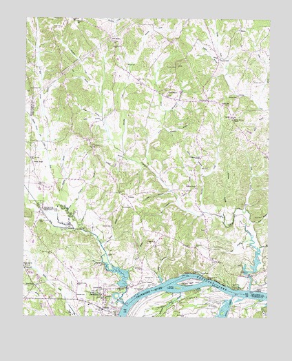
Thurman, TN USGS Topographic Map
Click on map above to begin viewing in our Map Viewer.

This topographic map contains these locations and features:
Feature Name Type Latitude Longitude GNIS ID View Map
Adkisson CemeteryCemeteryN35.4837°W88.1509°1275494View Map
Altom BranchStreamN35.4137°W88.1345°1269301View Map
Altom CemeteryCemeteryN35.4170°W88.1281°1275644View Map
Barber BranchStreamN35.4334°W88.1598°1276277View Map
Bath Springs Post OfficePost OfficeN35.4590°W88.1441°1650568View Map
Bath Springs School (historical)SchoolN35.4254°W88.1256°1316715View Map
Bear BranchStreamN35.4209°W88.1709°1276553View Map
Bell BranchStreamN35.4070°W88.1328°1276901View Map
Bethel CemeteryCemeteryN35.4965°W88.2320°1277107View Map
Buck BranchStreamN35.3890°W88.1789°1278789View Map
Buckeye BranchStreamN35.4029°W88.1289°1278847View Map
Butler CemeteryCemeteryN35.4526°W88.1296°2746185View Map
Carter BranchStreamN35.3804°W88.1986°1279774View Map
Center School (historical)SchoolN35.4834°W88.2286°1316727View Map
Centerview School (historical)SchoolN35.3856°W88.2075°1323770View Map
Cody BranchStreamN35.4198°W88.1364°1280855View Map
Colbert BranchStreamN35.4276°W88.1748°1280880View Map
Commissioner District 2CivilN35.4630°W88.2079°2463913View Map
Corinth BranchStreamN35.4051°W88.2103°1281302View Map
Corinth CemeteryCemeteryN35.4126°W88.2056°1307242View Map
Corinth ChurchChurchN35.4129°W88.2056°1306112View Map
Decatur County Volunteer Fire Department Station 2BuildingN35.4655°W88.1556°2654183View Map
Dickey LandingLocaleN35.3931°W88.1639°1314947View Map
Dickey TowheadIslandN35.3870°W88.1709°1306342View Map
Doe CreekStreamN35.3804°W88.1984°1282577View Map
Doe Creek ChurchChurchN35.4701°W88.2481°1282578View Map
Doe Creek School (historical)SchoolN35.4695°W88.2473°1317469View Map
Double BridgesLocaleN35.4184°W88.1584°1316738View Map
Dry BranchStreamN35.4723°W88.2131°1282835View Map
DunbarPopulated PlaceN35.4590°W88.1445°1314982View Map
East Prong Doe CreekStreamN35.4117°W88.2214°1283393View Map
Five ForksPopulated PlaceN35.3879°W88.2442°1315056View Map
Gilbert BranchStreamN35.4592°W88.2403°1285366View Map
Hailey BranchStreamN35.4212°W88.1709°1286501View Map
HaneyPopulated PlaceN35.4962°W88.1400°1315184View Map
Haney School (historical)SchoolN35.4954°W88.1406°1316746View Map
Hardin County Fire Department / Emergency Management District 1 Station 1BuildingN35.3759°W88.2098°2654249View Map
Hineman BranchStreamN35.4173°W88.1473°1287880View Map
Hoad BranchStreamN35.4584°W88.2106°1287933View Map
Holland BranchStreamN35.4415°W88.1970°1288049View Map
Holland CemeteryCemeteryN35.3751°W88.2039°1288059View Map
Indian CreekStreamN35.3840°W88.1420°1269672View Map
Johnston CemeteryCemeteryN35.4734°W88.1286°1289669View Map
Keeton Springs ChurchChurchN35.4576°W88.1436°1289969View Map
Kelley CemeteryCemeteryN35.4034°W88.1534°1289999View Map
Ladins LandingLocaleN35.3867°W88.1492°1315341View Map
Lafferty CemeteryCemeteryN35.4670°W88.1414°1290471View Map
Laster BranchStreamN35.4573°W88.2103°1290663View Map
LibertyPopulated PlaceN35.4462°W88.2148°1291106View Map
Liberty ChurchChurchN35.4462°W88.2145°1316751View Map
Liberty School (historical)SchoolN35.4454°W88.2156°1316752View Map
Lick SkilletPopulated PlaceN35.4906°W88.2059°1291245View Map
Lincoln SchoolSchoolN35.3867°W88.2098°1291311View Map
Little CreekStreamN35.4637°W88.1298°1291459View Map
Lowery CemeteryCemeteryN35.4484°W88.2470°1292231View Map
Middle Prong Doe CreekStreamN35.4612°W88.2386°1310584View Map
Middle Tennessee Agricultural StationStreamN35.4445°W88.2389°1293686View Map
Mile BranchStreamN35.3937°W88.1967°1293770View Map
MontgomeryPopulated PlaceN35.4654°W88.1564°1294189View Map
Montgomery BranchStreamN35.4612°W88.1784°1294194View Map
Morningview ChurchChurchN35.3842°W88.2098°1294402View Map
Murphy CemeteryCemeteryN35.4806°W88.1984°1295114View Map
Murphy CreekStreamN35.4434°W88.1998°1295120View Map
North Prong Stewman CreekStreamN35.4323°W88.1800°1295940View Map
Old Dunbar (historical)Populated PlaceN35.4656°W88.1673°1310586View Map
Pleasant GrovePopulated PlaceN35.4290°W88.1620°1315731View Map
Pleasant Grove ChurchChurchN35.4415°W88.1600°1297817View Map
Pleasant HillPopulated PlaceN35.4829°W88.1511°1315732View Map
Pleasant Hill United Methodist ChurchChurchN35.4834°W88.1500°1644673View Map
Point PleasantPopulated PlaceN35.3892°W88.1892°1315748View Map
Point Pleasant LandingLocaleN35.3859°W88.1886°1315749View Map
Presley RidgePopulated PlaceN35.4390°W88.2459°1298476View Map
Red WalnutPopulated PlaceN35.4692°W88.1770°1315796View Map
Russell CemeteryCemeteryN35.3820°W88.1570°1300307View Map
Saint Marys ChurchChurchN35.3845°W88.2109°1300478View Map
SaltilloPopulated PlaceN35.3779°W88.2095°1300596View Map
Saltillo CemeteryCemeteryN35.3859°W88.2114°1300597View Map
Saltillo Elementary SchoolSchoolN35.3801°W88.2161°1323927View Map
Saltillo Fire Department District 1BuildingN35.3759°W88.2098°2654285View Map
Saltillo LandingLocaleN35.3770°W88.2003°1323928View Map
Saltillo MarinaLocaleN35.3756°W88.2009°1323930View Map
Saltillo Post OfficePost OfficeN35.3786°W88.2113°1652269View Map
Shady GrovePopulated PlaceN35.3965°W88.2489°1315901View Map
Shady Grove CemeteryCemeteryN35.3965°W88.2478°1323941View Map
Shady Grove ChurchChurchN35.3965°W88.2489°1310162View Map
Shannon CemeteryCemeteryN35.3915°W88.1834°1301226View Map
Shelby Pond (historical)LakeN35.3887°W88.1870°1310589View Map
Stanfield BranchStreamN35.4259°W88.2317°1271231View Map
Stewman CreekStreamN35.3862°W88.1339°1303841View Map
Swallow BluffCliffN35.3890°W88.1489°1271924View Map
Swallow Bluff IslandIslandN35.3892°W88.1645°1303955View Map
Swallow Bluff LandingLocaleN35.3867°W88.1431°1314366View Map
Tanyard BranchStreamN35.3948°W88.2459°1272106View Map
ThurmanPopulated PlaceN35.4254°W88.1986°1314403View Map
Thurman CreekStreamN35.4187°W88.1578°1272603View Map
Thurman SchoolSchoolN35.4209°W88.1948°1272607View Map
Town of SaltilloCivilN35.3818°W88.2339°2407279View Map
Tucker BranchStreamN35.4795°W88.1475°1272938View Map
Union HallLocaleN35.4645°W88.1500°1273229View Map
Union Hall School (historical)SchoolN35.4634°W88.1456°1316780View Map
UnityPopulated PlaceN35.4115°W88.1564°1314439View Map
Unity ChurchChurchN35.4106°W88.1567°1316781View Map
Unity School (historical)SchoolN35.4104°W88.1564°1307246View Map
West Prong Doe CreekStreamN35.4115°W88.2214°1274219View Map
Whetstone BranchStreamN35.4542°W88.1795°1274299View Map
Whitelawn CemeteryCemeteryN35.3845°W88.2231°1274421View Map
Wiley CemeteryCemeteryN35.4370°W88.1559°1304590View Map
Wilkinson Pond SloughStreamN35.3851°W88.1695°1274601View Map
Wormley BranchStreamN35.4192°W88.2275°1275134View Map
Wyatt LandingLocaleN35.3856°W88.1281°1314539View Map

Note: Coordinates in the location and feature list above are referenced to NAD83 datum.


Copyright (C) 2008-2024 Ryan Niemi / Sunset Dynamics ... All Rights Reserved