TopoQuest Logo
Do you find TopoQuest useful?
Help keep TopoQuest running and adding new maps/features by donating!
Bitcoin:  19c7KJd3qBynnjoSw5npx9KScwjBe4ifkT
Litecoin:  LXs6TkuXGGXo1vDsWCkWVdjQX94eUKd6ui
Home View Maps Find Maps Find Places Resources & Links


Hornsby, Tennessee Topographic Map

USGS Map Title: Hornsby, TN
USGS Map MRC: 35088B7
DRG (GeoTIFF) Download: o35088b7.tif


Neighboring USGS Topographic Map Quads:


  Bolivar East, TN  
35088C8
 

  Silerton, TN  
35088C7
 

  Masseyville, TN  
35088C6
 

  Hebron, TN  
35088B8
 

  Hornsby, TN  
35088B7
 

  Rose Creek, TN  
35088B6
 

  Middleton, TN  
35088A8
 

  Pocahontas, TN  
35088A7
 

  Chewalla, TN  
35088A6


Map MRC Location:

N36°
W89°
N36°
W88°
H8 H7 H6 H5 H4 H3 H2 H1
G8 G7 G6 G5 G4 G3 G2 G1
F8 F7 F6 F5 F4 F3 F2 F1
E8 E7 E6 E5 E4 E3 E2 E1
D8 D7 D6 D5 D4 D3 D2 D1
C8 C7 C6 C5 C4 C3 C2 C1
B8 B7 B6 B5 B4 B3 B2 B1
A8 A7 A6 A5 A4 A3 A2 A1
N35°
W89°
N35°
W88°

Hornsby, TN USGS 1:24K Topographic Map Preview:
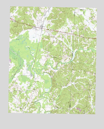
Hornsby, TN USGS Topographic Map
Click on map above to begin viewing in our Map Viewer.

This topographic map contains these locations and features:
Feature Name Type Latitude Longitude GNIS ID View Map
Bass CemeteryCemeteryN35.1509°W88.8667°1276432View Map
Brints ChapelChurchN35.1620°W88.8370°1305423View Map
Chapel Hill ChurchChurchN35.1456°W88.7592°1305851View Map
Cypress CreekStreamN35.1868°W88.7851°1281925View Map
Dog Tail CreekStreamN35.2148°W88.8498°1282596View Map
Ervin BranchStreamN35.2284°W88.8239°1283844View Map
Fish BranchStreamN35.1965°W88.7803°1284303View Map
Grantham CemeteryCemeteryN35.1523°W88.8389°1285852View Map
Hatchie CemeteryCemeteryN35.2029°W88.8178°1287118View Map
HornsbyPopulated PlaceN35.2276°W88.8295°1288378View Map
Hornsby Baptist ChurchChurchN35.2276°W88.8306°1319764View Map
Hornsby Division (historical)CensusN35.2392°W88.8517°1648747View Map
Hornsby Elementary SchoolSchoolN35.2265°W88.8312°1319765View Map
Hornsby Post OfficePost OfficeN35.2251°W88.8292°1651312View Map
Hornsby Volunteer Fire DepartmentBuildingN35.2251°W88.8294°2654164View Map
J J Madison DamDamN35.1318°W88.7767°1301590View Map
J J Madison LakeReservoirN35.1304°W88.7733°1307062View Map
King BranchStreamN35.2420°W88.7692°1290188View Map
Little Hatchie ChurchChurchN35.1901°W88.8076°1291522View Map
Little Hatchie CreekStreamN35.1756°W88.8303°1291524View Map
Magbee BranchStreamN35.1695°W88.8392°1292494View Map
McCalip SchoolSchoolN35.1590°W88.7576°1293099View Map
McCalips ChapelChurchN35.1587°W88.7573°1308691View Map
McCalips Chapel CemeteryCemeteryN35.1590°W88.7575°1308692View Map
McNairy County Fire Department Station 42 Byrd Locke Fire DepartmentBuildingN35.1536°W88.7599°2654001View Map
Porters CreekPopulated PlaceN35.1306°W88.8567°1647502View Map
Porters Creek ChurchChurchN35.1306°W88.8570°1298276View Map
Porters Creek SloughStreamN35.1834°W88.8562°1269870View Map
Powells ChapelChurchN35.1312°W88.8034°1298431View Map
Prairie BranchStreamN35.1501°W88.8484°1298443View Map
SerlesPopulated PlaceN35.1693°W88.8437°1301082View Map
Skipper CreekStreamN35.1490°W88.8181°1270443View Map
Stanley CemeteryCemeteryN35.1506°W88.8587°1271238View Map
The Big BottomBasinN35.1904°W88.8684°1272368View Map
Town of HornsbyCivilN35.2295°W88.8302°2405865View Map
Wade CreekStreamN35.2126°W88.8514°1273519View Map
Walnut Grove SchoolSchoolN35.2323°W88.8670°1273731View Map
Wyatt CemeteryCemeteryN35.2387°W88.8326°1275195View Map

Note: Coordinates in the location and feature list above are referenced to NAD83 datum.


Copyright (C) 2008-2024 Ryan Niemi / Sunset Dynamics ... All Rights Reserved