TopoQuest Logo
Do you find TopoQuest useful?
Help keep TopoQuest running and adding new maps/features by donating!
Bitcoin:  19c7KJd3qBynnjoSw5npx9KScwjBe4ifkT
Litecoin:  LXs6TkuXGGXo1vDsWCkWVdjQX94eUKd6ui
Home View Maps Find Maps Find Places Resources & Links


Bolivar East, Tennessee Topographic Map

USGS Map Title: Bolivar East, TN
USGS Map MRC: 35088C8
DRG (GeoTIFF) Download: o35088c8.tif


Neighboring USGS Topographic Map Quads:


  Mercer, TN  
35089D1
 

  Teague, TN  
35088D8
 

  Medon, TN  
35088D7
 

  Bolivar West, TN  
35089C1
 

  Bolivar East, TN  
35088C8
 

  Silerton, TN  
35088C7
 

  Middleburg, TN  
35089B1
 

  Hebron, TN  
35088B8
 

  Hornsby, TN  
35088B7


Map MRC Location:

N36°
W89°
N36°
W88°
H8 H7 H6 H5 H4 H3 H2 H1
G8 G7 G6 G5 G4 G3 G2 G1
F8 F7 F6 F5 F4 F3 F2 F1
E8 E7 E6 E5 E4 E3 E2 E1
D8 D7 D6 D5 D4 D3 D2 D1
C8 C7 C6 C5 C4 C3 C2 C1
B8 B7 B6 B5 B4 B3 B2 B1
A8 A7 A6 A5 A4 A3 A2 A1
N35°
W89°
N35°
W88°

Bolivar East, TN USGS 1:24K Topographic Map Preview:
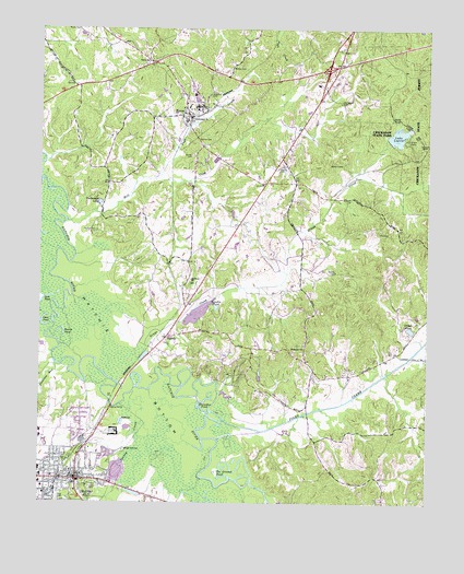
Bolivar East, TN USGS Topographic Map
Click on map above to begin viewing in our Map Viewer.

This topographic map contains these locations and features:
Feature Name Type Latitude Longitude GNIS ID View Map
Beaver PondLakeN35.3339°W88.9967°2094555View Map
Bills-McNeal Historic DistrictParkN35.2548°W88.9917°1326477View Map
BolivarPopulated PlaceN35.2562°W88.9878°1269372View Map
Bolivar City HallBuildingN35.2567°W88.9895°1319742View Map
Bolivar Courthouse Square Historic DistrictParkN35.2562°W88.9878°1326478View Map
Bolivar Fire DepartmentBuildingN35.2573°W88.9895°2653622View Map
Bolivar First Baptist ChurchChurchN35.2570°W88.9995°1319745View Map
Bolivar General HospitalHospitalN35.2676°W88.9994°1319743View Map
Bolivar Industrial School (historical)SchoolN35.2526°W88.9981°1647983View Map
Bolivar Methodist ChurchChurchN35.2565°W88.9901°1647984View Map
Bolivar Police DepartmentBuildingN35.2569°W88.9898°2765839View Map
Bolivar Post OfficePost OfficeN35.2558°W88.9870°1651304View Map
Bradford CemeteryCemeteryN35.3581°W88.9459°1278161View Map
Cearley CemeteryCemeteryN35.3387°W88.9239°1279986View Map
Commissioner District 7CivilN35.2736°W88.8786°2464613View Map
Concord CemeteryCemeteryN35.3445°W88.8751°1269487View Map
Cumberland ChurchChurchN35.3515°W88.9526°1281823View Map
Ebenezer ChurchChurchN35.2909°W88.9148°1283466View Map
Gibson CemeteryCemeteryN35.3395°W88.9034°1285341View Map
Gibson PondReservoirN35.2959°W88.8803°1285353View Map
Grays CreekStreamN35.2837°W88.9701°1286023View Map
Hardeman County Ambulance ServiceBuildingN35.2639°W88.9844°2697404View Map
Hardeman county CourthouseBuildingN35.2565°W88.9706°1319759View Map
Hardeman County JailBuildingN35.2554°W88.9876°1647985View Map
Hardeman County LibraryBuildingN35.2584°W88.9895°1319758View Map
Hardeman County Sheriff's OfficeBuildingN35.2522°W88.9862°2765860View Map
Harris PondLakeN35.2953°W88.9940°1286994View Map
Hillfield ChurchChurchN35.3087°W88.9517°1287832View Map
Horseshoe PondLakeN35.2751°W88.9484°1288455View Map
Jack PondLakeN35.3041°W88.9974°1289160View Map
Lake LajoiceReservoirN35.3470°W88.8849°1306659View Map
Lake Lajoie DamDamN35.3457°W88.8878°1307104View Map
McLendon CemeteryCemeteryN35.3565°W88.9034°1293407View Map
Mill CreekStreamN35.3245°W88.9917°1293820View Map
Mount Zion ChurchChurchN35.3545°W88.9470°1294875View Map
North Main Street Historic DistrictParkN35.2587°W88.9878°1326479View Map
Otter PondLakeN35.2965°W88.9984°1296521View Map
Overton CemeteryCemeteryN35.3459°W88.9501°1296546View Map
Piney CreekStreamN35.2740°W88.9451°1297621View Map
Pleasant RunStreamN35.2865°W88.9948°1297920View Map
Polk CemeteryCemeteryN35.2515°W88.9939°1298056View Map
Pugh CreekStreamN35.3356°W88.9634°1298656View Map
Ruffian CemeteryCemeteryN35.3217°W88.9823°1300240View Map
Saint James Episcopal ChurchChurchN35.2551°W88.9895°1647986View Map
Saint Pauls Christian Methodist Episcopal Church (historical)ChurchN35.2545°W88.9801°1647987View Map
ShandyPopulated PlaceN35.2937°W88.9592°1301211View Map
Shandy Baptist ChurchChurchN35.2926°W88.9595°1319780View Map
Spring CreekStreamN35.2795°W88.9695°1271075View Map
Springfield Baptist ChurchChurchN35.2531°W88.9976°1647988View Map
The Grinnel PondLakeN35.2581°W88.9431°1272396View Map
ToonePopulated PlaceN35.3523°W88.9526°1304137View Map
Toone Division (historical)CensusN35.3620°W88.9434°1648749View Map
Toone Elementary SchoolSchoolN35.3545°W88.9523°1319783View Map
Toone Post OfficePost OfficeN35.3514°W88.9512°1651326View Map
Toone SchoolSchoolN35.3665°W88.9659°1272775View Map
Toone Volunteer Fire DepartmentBuildingN35.3643°W88.9588°2653890View Map
Town of TooneCivilN35.3565°W88.9541°2406742View Map
Union CemeteryCemeteryN35.2542°W88.9834°1273182View Map
Vaughn PondLakeN35.3010°W88.9471°1273414View Map
Walton CemeteryCemeteryN35.3112°W88.9051°1273752View Map
Watson CemeteryCemeteryN35.3654°W88.9389°1273918View Map
WBOL-AM (Bolivar)TowerN35.2584°W88.9806°1639844View Map
WVST-FM (Bolivar)TowerN35.2501°W88.8912°1640039View Map
Yarbrough LakeReservoirN35.3292°W88.9808°1275239View Map
Zion ChurchChurchN35.2606°W88.9917°1275361View Map

Note: Coordinates in the location and feature list above are referenced to NAD83 datum.


Copyright (C) 2008-2024 Ryan Niemi / Sunset Dynamics ... All Rights Reserved