TopoQuest Logo
Do you find TopoQuest useful?
Help keep TopoQuest running and adding new maps/features by donating!
Bitcoin:  19c7KJd3qBynnjoSw5npx9KScwjBe4ifkT
Litecoin:  LXs6TkuXGGXo1vDsWCkWVdjQX94eUKd6ui
Home View Maps Find Maps Find Places Resources & Links


Waverly, Tennessee Topographic Map

USGS Map Title: Waverly, TN
USGS Map MRC: 36087A7
DRG (GeoTIFF) Download: o36087a7.tif


Neighboring USGS Topographic Map Quads:


  Harmon Creek, TN  
36087B8
 

  Halls Creek, TN  
36087B7
 

  Woolworth, TN  
36087B6
 

  Johnsonville, TN  
36087A8
 

  Waverly, TN  
36087A7
 

  McEwen, TN  
36087A6
 

  Hustburg, TN  
35087H8
 

  Hurricane Mills, TN  
35087H7
 

  Bucksnort, TN  
35087H6


Map MRC Location:

N37°
W88°
N37°
W87°
H8 H7 H6 H5 H4 H3 H2 H1
G8 G7 G6 G5 G4 G3 G2 G1
F8 F7 F6 F5 F4 F3 F2 F1
E8 E7 E6 E5 E4 E3 E2 E1
D8 D7 D6 D5 D4 D3 D2 D1
C8 C7 C6 C5 C4 C3 C2 C1
B8 B7 B6 B5 B4 B3 B2 B1
A8 A7 A6 A5 A4 A3 A2 A1
N36°
W88°
N36°
W87°

Waverly, TN USGS 1:24K Topographic Map Preview:
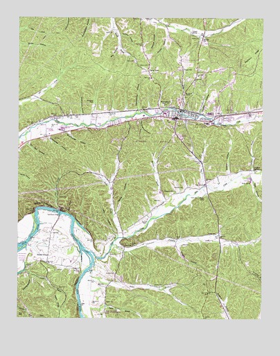
Waverly, TN USGS Topographic Map
Click on map above to begin viewing in our Map Viewer.

This topographic map contains these locations and features:
Feature Name Type Latitude Longitude GNIS ID View Map
Arnold CemeteryCemeteryN36.1242°W87.8122°1275889View Map
Arnold HollowValleyN36.1202°W87.7991°1275891View Map
Bear BranchStreamN36.0545°W87.7806°1276557View Map
Beasley CemeteryCemeteryN36.0351°W87.7739°1276678View Map
Big HollowValleyN36.1127°W87.8237°1277320View Map
Blue CreekStreamN36.0278°W87.8375°1277753View Map
Brady BranchStreamN36.0334°W87.8239°1278205View Map
Brickhouse HollowValleyN36.0775°W87.8496°1278331View Map
Buck HollowValleyN36.0437°W87.8500°1278820View Map
Bucket BranchStreamN36.0198°W87.8386°1278845View Map
Burnham CemeteriesCemeteryN36.0389°W87.8097°1279078View Map
Carnell CemeteryCemeteryN36.1162°W87.7828°1279686View Map
Carnell SpringSpringN36.1187°W87.7861°1279687View Map
Chambers BranchStreamN36.0606°W87.7556°1280208View Map
Chambers SpringSpringN36.0621°W87.7543°1280222View Map
City of WaverlyCivilN36.0942°W87.7851°2405693View Map
Cold BranchStreamN36.0451°W87.8539°1306019View Map
Cold Branch BridgeBridgeN36.0439°W87.8531°1280885View Map
Commissioner District 2CivilN36.1098°W87.7634°2463936View Map
Commissioner District 3CivilN36.0820°W87.7661°2464160View Map
Elysian GrovePopulated PlaceN36.0264°W87.8589°1283737View Map
Elysian Grove School (historical)SchoolN36.0270°W87.8603°1316933View Map
Fairview School (historical)SchoolN36.1220°W87.8034°1316934View Map
Forest HillPopulated PlaceN36.1034°W87.7909°1284589View Map
Fortner HollowValleyN36.1211°W87.8043°1328216View Map
George CemeteryCemeteryN36.0209°W87.8425°1285296View Map
GlenwoodPopulated PlaceN36.0301°W87.8203°1315123View Map
Glenwood School (historical)SchoolN36.0298°W87.8184°1316939View Map
Glenwood United Methodist ChurchChurchN36.0298°W87.8186°1316940View Map
Gwin CemeteryCemeteryN36.0084°W87.8309°1316942View Map
Harris CemeteryCemeteryN36.0670°W87.7820°1286968View Map
Hemby CemeteryCemeteryN36.1070°W87.8153°1287362View Map
Hemby CemeteryCemeteryN36.1192°W87.8261°1287363View Map
Hobbs CemeteryCemeteryN36.0842°W87.8445°1287936View Map
Hopkins CrossingPopulated PlaceN36.0845°W87.7736°1288333View Map
Hugh Link Farm State Archaeological AreaParkN36.0028°W87.8292°1316949View Map
Humphreys CountyCivilN36.0408°W87.7756°1639757View Map
Humphreys County CourthouseBuildingN36.0828°W87.7947°1316950View Map
Humphreys County Farm (historical)LocaleN36.0831°W87.8556°1316951View Map
Humphreys County Fire Department District 2BuildingN36.0741°W87.7922°2653710View Map
Humphreys County LibraryBuildingN36.0856°W87.7961°1316952View Map
Humphreys County Nursing HomeBuildingN36.0745°W87.7911°1316953View Map
Humphreys County Sheriff's OfficeBuildingN36.0825°W87.7966°2765753View Map
Humphreys County Vocational SchoolSchoolN36.0912°W87.7928°1316954View Map
Johnson ShoalsBarN36.0237°W87.8364°1310658View Map
Knight CemeteryCemeteryN36.0306°W87.8159°1290361View Map
Knight HollowValleyN36.0306°W87.7940°1290369View Map
Lake HollowValleyN36.0346°W87.8244°1290491View Map
Link CemeteryCemeteryN36.0023°W87.8309°1291343View Map
Mathews BranchStreamN36.0417°W87.8053°1292924View Map
Matthews HollowValleyN36.0486°W87.8007°1647373View Map
Mays CemeteryCemeteryN36.0131°W87.8500°1293029View Map
Mays CemeteryCemeteryN36.0359°W87.8536°1293030View Map
McAdoo CemeteryCemeteryN36.0506°W87.8539°1293064View Map
McKelvy CemeteryCemeteryN36.0864°W87.7656°1293351View Map
McKelvy HollowValleyN36.1177°W87.8229°1293352View Map
Mount Olivet ChurchChurchN36.0931°W87.7897°1294727View Map
Negro HollowValleyN36.0874°W87.7914°1310663View Map
Negro RidgeRidgeN36.0070°W87.8542°1295352View Map
Nelson CemeteryCemeteryN36.0264°W87.8236°1295371View Map
O'Guinn CemeteryCemeteryN36.0528°W87.7936°1316976View Map
Old Fairground HollowValleyN36.0826°W87.8127°1296301View Map
Old Fields PlacePopulated PlaceN36.0903°W87.8370°1296305View Map
Old Fields Place BranchStreamN36.0806°W87.8384°1310665View Map
Old Mill HollowValleyN36.0727°W87.8705°1296339View Map
Paint Rock BluffCliffN36.0453°W87.8664°1296665View Map
Pennywinkle HollowValleyN36.0874°W87.8134°1297165View Map
Pigeon RoostPopulated PlaceN36.1031°W87.8081°1297442View Map
Pleasant Hill ChurchChurchN36.0531°W87.7939°1297874View Map
Pleasant Hill School (historical)SchoolN36.0526°W87.7942°1316984View Map
Poorhouse HollowValleyN36.0754°W87.8595°1298156View Map
Pruett CemeteryCemeteryN36.0203°W87.8553°1298620View Map
Pumpkin CreekStreamN36.0306°W87.8259°1298678View Map
Rogers CemeteryCemeteryN36.0070°W87.8295°1299990View Map
Sectionhouse HollowValleyN36.0850°W87.8425°1301027View Map
Simpson CemeteryCemeteryN36.0139°W87.8042°1270337View Map
Simpson CemeteryCemeteryN36.0192°W87.8250°1270338View Map
Slayden HollowValleyN36.0855°W87.7822°1270502View Map
Spann School (historical)SchoolN36.0853°W87.8528°1316996View Map
Spence HollowValleyN36.0596°W87.7675°1270983View Map
Spring HollowValleyN36.0186°W87.8691°1271121View Map
Stairstep HillSummitN36.0487°W87.8739°1310676View Map
Thompson CemeteryCemeteryN36.0545°W87.7900°1272523View Map
Three Rivers HospitalHospitalN36.0760°W87.7923°1317011View Map
Tubbs CemeteryCemeteryN36.0509°W87.7825°1272928View Map
Tubbs Ford BridgeBridgeN36.0556°W87.7786°1272929View Map
Tubbs SpringSpringN36.0505°W87.7820°1272931View Map
Ussery HollowValleyN36.1239°W87.8030°1304280View Map
Vaden CemeteryCemeteryN36.0309°W87.7906°1273321View Map
WaverlyPopulated PlaceN36.0839°W87.7947°1273950View Map
Waverly Central High SchoolSchoolN36.0789°W87.8525°1317006View Map
Waverly City HallBuildingN36.0834°W87.7936°1317007View Map
Waverly City ParkParkN36.0884°W87.7786°1317008View Map
Waverly Country ClubLocaleN36.0903°W87.7775°1317009View Map
Waverly Division (historical)CensusN36.0739°W87.8475°1648790View Map
Waverly Elementary SchoolSchoolN36.0812°W87.7756°1317010View Map
Waverly Fire DepartmentBuildingN36.0833°W87.7925°2653759View Map
Waverly First Baptist ChurchChurchN36.0823°W87.7892°1644761View Map
Waverly Junior High SchoolSchoolN36.0812°W87.7786°1317013View Map
Waverly Plaza Shopping CenterLocaleN36.0842°W87.8000°1317015View Map
Waverly Police DepartmentBuildingN36.0834°W87.7932°2765821View Map
Waverly Post OfficePost OfficeN36.0846°W87.8016°1650658View Map
Wells CemeteryCemeteryN36.0151°W87.8325°1274106View Map
White CemeteryCemeteryN36.0492°W87.8014°1274349View Map
White HollowValleyN36.0441°W87.8245°1274375View Map
WPHC-AM (Waverly)TowerN36.0826°W87.8347°1639940View Map
WVRY-FM (Waverly)TowerN36.0878°W87.8553°1640096View Map
Wyly CemeteryCemeteryN36.0814°W87.7867°1275206View Map
Wyly HollowValleyN36.0576°W87.7555°1275207View Map
Wyly SpringSpringN36.0570°W87.7561°1275208View Map

Note: Coordinates in the location and feature list above are referenced to NAD83 datum.


Copyright (C) 2008-2024 Ryan Niemi / Sunset Dynamics ... All Rights Reserved