TopoQuest Logo
Do you find TopoQuest useful?
Help keep TopoQuest running and adding new maps/features by donating!
Bitcoin:  19c7KJd3qBynnjoSw5npx9KScwjBe4ifkT
Litecoin:  LXs6TkuXGGXo1vDsWCkWVdjQX94eUKd6ui
Home View Maps Find Maps Find Places Resources & Links


McEwen, Tennessee Topographic Map

USGS Map Title: McEwen, TN
USGS Map MRC: 36087A6
DRG (GeoTIFF) Download: o36087a6.tif


Neighboring USGS Topographic Map Quads:


  Halls Creek, TN  
36087B7
 

  Woolworth, TN  
36087B6
 

  Ruskin, TN  
36087B5
 

  Waverly, TN  
36087A7
 

  McEwen, TN  
36087A6
 

  Tennessee City, TN  
36087A5
 

  Hurricane Mills, TN  
35087H7
 

  Bucksnort, TN  
35087H6
 

  Spot, TN  
35087H5


Map MRC Location:

N37°
W88°
N37°
W87°
H8 H7 H6 H5 H4 H3 H2 H1
G8 G7 G6 G5 G4 G3 G2 G1
F8 F7 F6 F5 F4 F3 F2 F1
E8 E7 E6 E5 E4 E3 E2 E1
D8 D7 D6 D5 D4 D3 D2 D1
C8 C7 C6 C5 C4 C3 C2 C1
B8 B7 B6 B5 B4 B3 B2 B1
A8 A7 A6 A5 A4 A3 A2 A1
N36°
W88°
N36°
W87°

McEwen, TN USGS 1:24K Topographic Map Preview:
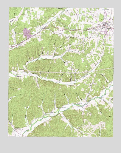
McEwen, TN USGS Topographic Map
Click on map above to begin viewing in our Map Viewer.

This topographic map contains these locations and features:
Feature Name Type Latitude Longitude GNIS ID View Map
Anderson CemeteryCemeteryN36.0584°W87.7247°1275707View Map
Baker HollowValleyN36.0319°W87.6781°1276182View Map
Balding KnobSummitN36.0198°W87.6253°1276220View Map
Beech Grove ChurchChurchN36.0645°W87.7317°1276835View Map
Beech Grove School (historical)SchoolN36.0645°W87.7314°1316911View Map
Bennyfield CemeteryCemeteryN36.0945°W87.7120°1277021View Map
Bethel CemeteryCemeteryN36.0967°W87.6753°1277114View Map
Bethel Church (historical)ChurchN36.0967°W87.6759°1316915View Map
BethpagePopulated PlaceN36.0345°W87.6278°1313647View Map
Bethpage CemeteryCemeteryN36.0373°W87.6275°1277179View Map
Breadens SpringSpringN36.0236°W87.6993°1278265View Map
Brushy Spring BranchStreamN36.0859°W87.6928°1278723View Map
Burns HollowValleyN36.1001°W87.7146°1647372View Map
Bushwacker HollowValleyN36.0338°W87.6629°1279149View Map
Butts HollowValleyN36.0570°W87.7051°1279208View Map
Campground HollowValleyN36.0589°W87.7125°1279481View Map
Centralview School (historical)SchoolN36.0295°W87.6606°1316922View Map
Chambers CemeteryCemeteryN36.0839°W87.6781°1280212View Map
Choate CemeteryCemeteryN36.0798°W87.6936°1280500View Map
Choate HollowValleyN36.0781°W87.6971°1280503View Map
City of McEwenCivilN36.1098°W87.6357°2405048View Map
Claudes ChapelChurchN36.1245°W87.6861°1280617View Map
Conley BranchStreamN36.1148°W87.6961°1281087View Map
Craft HollowValleyN36.0547°W87.6701°1306165View Map
Douglass HollowValleyN36.0342°W87.6285°1282748View Map
Dunn HollowValleyN36.0847°W87.6775°1283210View Map
Enoch HollowValleyN36.0774°W87.6880°1283807View Map
Forks of Blue CreekPopulated PlaceN36.0639°W87.7317°1313648View Map
Forsee SpringSpringN36.0318°W87.6685°1284656View Map
Garrett CemeteryCemeteryN36.0539°W87.6922°1285190View Map
Goodrich HollowValleyN36.0110°W87.7264°1285652View Map
GormanPopulated PlaceN36.1045°W87.7078°1285710View Map
Gorman Freewill Baptist Church (historical)ChurchN36.1045°W87.7075°1326204View Map
Hedge HollowValleyN36.0335°W87.6563°1287324View Map
Holland CemeteryCemeteryN36.0556°W87.6689°1288056View Map
Humphreys County AirportAirportN36.1147°W87.7415°1301398View Map
Humphreys County Fire Department District 3 / City of McEwen Fire DepartmentBuildingN36.1065°W87.6357°2653674View Map
Hunter SpringSpringN36.0281°W87.6871°1288749View Map
Johnson CemeteryCemeteryN36.0284°W87.6917°1289560View Map
Johnson HollowValleyN36.0262°W87.6929°1289616View Map
Jones HollowValleyN36.0537°W87.6895°1289805View Map
LibertyPopulated PlaceN36.0789°W87.6872°1313649View Map
Liberty Baptist Church (historical)ChurchN36.0853°W87.6786°1326206View Map
Liberty SchoolSchoolN36.0812°W87.6842°1291165View Map
Little Blue CreekStreamN36.0623°W87.7342°1291391View Map
Little Hurricane CreekStreamN36.0381°W87.6420°1291540View Map
Long CemeteryCemeteryN36.0234°W87.7064°1291919View Map
Long SpringSpringN36.0224°W87.7056°1292011View Map
Macadues Mill (historical)LocaleN36.0384°W87.6422°1316959View Map
Mackins HollowValleyN36.0210°W87.7065°1292454View Map
Marker BranchStreamN36.0228°W87.6897°1292691View Map
May HollowValleyN36.0585°W87.7146°1292998View Map
McCandless Bridge (historical)BridgeN36.0301°W87.6614°1316963View Map
McCandless CemeteryCemeteryN36.0298°W87.6617°1293115View Map
McCollum CemeteryCemeteryN36.0501°W87.6775°1293173View Map
McEwenPopulated PlaceN36.1078°W87.6331°1293272View Map
McEwen Division (historical)CensusN36.1176°W87.6325°1648789View Map
McEwen First Baptist ChurchChurchN36.1073°W87.6364°1644757View Map
McEwen Industrial ParkLocaleN36.1098°W87.6528°1316966View Map
McEwen Police DepartmentBuildingN36.1078°W87.6335°2765956View Map
McEwen Post OfficePost OfficeN36.1084°W87.6350°1650647View Map
McEwen SchoolSchoolN36.1137°W87.6300°1316967View Map
Mill HollowValleyN36.0775°W87.7131°1293878View Map
Mitchell HollowValleyN36.0893°W87.7428°1294109View Map
Moon HollowValleyN36.0860°W87.6931°1294225View Map
Mullinax HollowValleyN36.0538°W87.6756°1295080View Map
Needmore ChurchChurchN36.1234°W87.6361°1295309View Map
New Bethel ChurchChurchN36.1042°W87.6445°1295434View Map
New Bethpage Church (historical)ChurchN36.0365°W87.6278°1326207View Map
New HopePopulated PlaceN36.0390°W87.6389°1315591View Map
New Hope Methodist ChurchChurchN36.0384°W87.6397°1326322View Map
O'Neal HollowValleyN36.0776°W87.7033°1296043View Map
Oak Grove School (historical)SchoolN36.0273°W87.6900°1316975View Map
Petty HollowValleyN36.0356°W87.6464°1297280View Map
Pleasant Ridge ChurchChurchN36.0967°W87.6709°1297913View Map
Providence ChurchChurchN36.0553°W87.6697°1306927View Map
Pruett ChapelChurchN36.0090°W87.7359°1298621View Map
Pruett Chapel School (historical)SchoolN36.0023°W87.7411°1316987View Map
Scurlock CemeteryCemeteryN36.0403°W87.7425°1300985View Map
Seifarth CemeteryCemeteryN36.1092°W87.7083°1301036View Map
Shiloh Church (historical)ChurchN36.0373°W87.6567°1316992View Map
Shiloh School (historical)SchoolN36.0367°W87.6575°1316993View Map
Shiloh SpringSpringN36.0362°W87.6567°1270100View Map
Simpson SpringSpringN36.0589°W87.7397°1270346View Map
Slaughter HillSummitN36.0898°W87.6639°1647376View Map
Slaughter HollowValleyN36.0502°W87.6292°1270490View Map
Stephany RidgeRidgeN36.1153°W87.7439°1271326View Map
Stringer HollowValleyN36.0781°W87.7113°1271596View Map
Trogden HollowValleyN36.0734°W87.7243°1272897View Map
Vaden BranchStreamN36.0120°W87.7456°1273320View Map
Wallace School (historical)SchoolN36.0553°W87.6695°1317005View Map
Waverly Industrial ParkLocaleN36.1126°W87.7459°1317012View Map

Note: Coordinates in the location and feature list above are referenced to NAD83 datum.


Copyright (C) 2008-2024 Ryan Niemi / Sunset Dynamics ... All Rights Reserved