TopoQuest Logo
Do you find TopoQuest useful?
Help keep TopoQuest running and adding new maps/features by donating!
Bitcoin:  19c7KJd3qBynnjoSw5npx9KScwjBe4ifkT
Litecoin:  LXs6TkuXGGXo1vDsWCkWVdjQX94eUKd6ui
Home View Maps Find Maps Find Places Resources & Links


Hustburg, Tennessee Topographic Map

USGS Map Title: Hustburg, TN
USGS Map MRC: 35087H8
DRG (GeoTIFF) Download: o35087h8.tif


Neighboring USGS Topographic Map Quads:


  Camden, TN  
36088A1
 

  Johnsonville, TN  
36087A8
 

  Waverly, TN  
36087A7
 

  Rockport, TN  
35088H1
 

  Hustburg, TN  
35087H8
 

  Hurricane Mills, TN  
35087H7
 

  Sugar Tree, TN  
35088G1
 

  Daniels Landing, TN  
35087G8
 

  Lobelville, TN  
35087G7


Map MRC Location:

N36°
W88°
N36°
W87°
H8 H7 H6 H5 H4 H3 H2 H1
G8 G7 G6 G5 G4 G3 G2 G1
F8 F7 F6 F5 F4 F3 F2 F1
E8 E7 E6 E5 E4 E3 E2 E1
D8 D7 D6 D5 D4 D3 D2 D1
C8 C7 C6 C5 C4 C3 C2 C1
B8 B7 B6 B5 B4 B3 B2 B1
A8 A7 A6 A5 A4 A3 A2 A1
N35°
W88°
N35°
W87°

Hustburg, TN USGS 1:24K Topographic Map Preview:
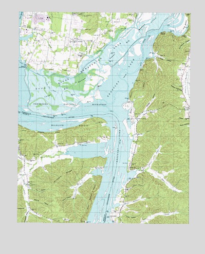
Hustburg, TN USGS Topographic Map
Click on map above to begin viewing in our Map Viewer.

This topographic map contains these locations and features:
Feature Name Type Latitude Longitude GNIS ID View Map
Arrington CemeteryCemeteryN35.9084°W87.9189°1304878View Map
Bakerville School (historical)SchoolN35.9476°W87.8784°1316908View Map
Beason BranchStreamN35.8962°W87.9242°1305033View Map
Blue CreekStreamN35.8759°W87.9328°1277752View Map
Briar CreekStreamN35.9670°W87.9942°1278310View Map
Broad SloughGutN35.9631°W87.9889°1310635View Map
Buchanans Landing (historical)LocaleN35.8995°W87.9284°1644746View Map
Burnett BranchStreamN35.9740°W87.9464°1305546View Map
Byrd CemeteryCemeteryN35.9348°W87.9384°1279248View Map
Byrd SchoolSchoolN35.9145°W87.9839°1305583View Map
Byrds LandingLocaleN35.9356°W87.9675°1316801View Map
Carroll HollowValleyN35.9356°W87.9139°1279748View Map
Chalk HollowValleyN35.9745°W87.8999°1280198View Map
Chappell CemeteryCemeteryN35.9898°W87.9528°1280269View Map
Chappell Hollow BranchStreamN35.9751°W87.9511°1305860View Map
Clear BranchStreamN35.9892°W87.8917°1280644View Map
Clear Lake (historical)LakeN35.9473°W87.9625°1310636View Map
Clear Lake DrainCanalN35.9562°W87.9789°1280677View Map
Clear SpringSpringN35.9048°W87.9109°1310637View Map
Clear Spring School (historical)SchoolN35.9048°W87.9100°1316923View Map
Cow Gap LandingLocaleN35.9390°W87.9711°1316925View Map
Crab PlaceLocaleN35.9373°W87.9495°1316817View Map
Craig HollowValleyN35.9146°W87.9977°1281547View Map
Crockett CemeteryCemeteryN35.9864°W87.9422°1281639View Map
Cuba HollowValleyN35.8752°W87.9259°1281800View Map
Cuba LandingLocaleN35.8792°W87.9328°1314919View Map
Cude CemeteryCemeteryN35.9776°W87.8753°1281807View Map
Cypress Pond (historical)LakeN35.9540°W87.9973°1310641View Map
DePriest CemeteryCemeteryN35.9220°W87.9714°1282243View Map
Dixie LandingLocaleN35.8887°W87.9320°1316929View Map
Dreden CemeteryCemeteryN35.9398°W87.9159°1282788View Map
Dry BranchStreamN35.9020°W87.9970°1282885View Map
Dry Branch CemeteryCemeteryN35.8984°W87.9914°1644698View Map
Dry Branch ChurchChurchN35.8976°W87.9920°1282893View Map
Dry Branch School (historical)SchoolN35.8970°W87.9923°1316821View Map
Duck BottomBendN35.9937°W87.8792°1283037View Map
Duck RiverStreamN35.9420°W87.9339°1269541View Map
Duck River Dewatering AreaBasinN35.9762°W87.9370°1283048View Map
Duck River Unit Tennessee National Wildlife RefugeParkN35.9584°W87.9500°1320992View Map
Dughill (historical)Populated PlaceN35.9915°W87.8764°1310643View Map
Dughill GapGapN35.9876°W87.8784°1283105View Map
Duncan BranchStreamN35.9065°W87.9078°1283142View Map
Eagle CreekStreamN35.9226°W87.9345°1283290View Map
Eagle CreekPopulated PlaceN35.9134°W87.9873°1314993View Map
Eagle Creek Baptist ChurchChurchN35.9156°W87.9834°1644699View Map
Eagle Creek CemeteryCemeteryN35.9162°W87.9834°1644700View Map
Ebenezer ChurchChurchN35.9831°W87.9628°1283475View Map
Estes CemeteryCemeteryN35.9895°W87.9842°1283862View Map
Foote Mineral Company Dam Number OneDamN35.9984°W87.9884°1302282View Map
Foote Mineral Company Tailings PondReservoirN35.9984°W87.9884°1302283View Map
Fowlkes CemeteryCemeteryN35.9667°W87.8797°1284756View Map
Fry HollowValleyN35.8958°W87.9921°1284998View Map
Grassy Lake DrainCanalN35.9484°W87.9842°1310649View Map
Haggard BranchStreamN35.9095°W87.9881°1303465View Map
Hamm CemeteryCemeteryN35.8817°W87.9275°1286671View Map
Harmon CreekStreamN35.9912°W87.9142°1286890View Map
High Bank LandingLocaleN35.9387°W87.9745°1316947View Map
Honey PointCliffN35.9890°W87.8945°1288203View Map
HustburgPopulated PlaceN35.9828°W87.9598°1288858View Map
Hustburg CreekStreamN35.9767°W87.9398°1288859View Map
Jones CemeteryCemeteryN35.9689°W87.8770°1289741View Map
Larkins CemeteryCemeteryN35.9906°W87.9267°1290648View Map
Lawrence CreekStreamN35.9767°W87.9398°1290785View Map
Lees Point LandingLocaleN35.9059°W87.9309°1316848View Map
Lewis HollowValleyN35.8949°W87.9576°1291086View Map
Liberty ChurchChurchN35.9606°W87.8817°1291133View Map
Link CemeteryCemeteryN35.9945°W87.9347°1291342View Map
Lower Big BottomBendN35.9540°W87.9631°1292209View Map
Matlock CemeteryCemeteryN35.9031°W87.9945°1292945View Map
McCallie LandingLocaleN35.9395°W87.9684°1317099View Map
Morris CemeteryCemeteryN35.9945°W87.9317°1294420View Map
Neblett CemeteryCemeteryN35.9998°W87.8778°1295290View Map
Oak Grove Church (historical)ChurchN35.9776°W87.9875°1316973View Map
Old Cathole (historical)LakeN35.9467°W87.9228°1310664View Map
Opossum CreekStreamN35.8853°W87.9303°1296454View Map
Opossum CreekStreamN35.9037°W87.9384°1296455View Map
Overcup SloughGutN35.9612°W87.9928°1310666View Map
Pavatt CemeteryCemeteryN35.9262°W87.9389°1296997View Map
Pavatt LandingLocaleN35.9209°W87.9292°1316865View Map
Pavatt School (historical)SchoolN35.9234°W87.9495°1316866View Map
PolecatPopulated PlaceN35.9567°W87.8806°1315750View Map
Polecat HollowValleyN35.9545°W87.8806°1298046View Map
Pond CreekStreamN35.9592°W87.8750°1298101View Map
Roberts CreekStreamN35.9048°W87.9223°1299637View Map
Rock College School (historical)SchoolN35.9015°W87.9553°1316878View Map
Rockport Island (historical)IslandN35.9370°W87.9967°1310618View Map
Simmons BranchStreamN35.9839°W87.9992°1270293View Map
Simmons Branch Industrial SiteLocaleN35.9792°W87.9903°1316995View Map
Sinkhole RidgeRidgeN35.9034°W87.9675°1303639View Map
Squirrel HollowValleyN35.8879°W87.9918°1271183View Map
Stribling BranchStreamN35.9912°W87.9142°1271585View Map
Swader HollowValleyN35.9420°W87.9073°1271914View Map
Sycamore BottomFlatN35.9417°W87.9250°1310678View Map
Sycamore LandingLocaleN35.9373°W87.9148°1314371View Map
Tanyard BranchStreamN35.9245°W87.9181°1272100View Map
Tribble High SchoolSchoolN35.9887°W87.9775°1648183View Map
Turner Landing (historical)LocaleN35.9401°W87.9509°1317002View Map
Upper Big BottomBendN35.9878°W87.9136°1273288View Map
Vanhook CemeteryCemeteryN35.9473°W87.9206°1273372View Map
Varbrough CemeteryCemeteryN35.9742°W87.9542°1273388View Map
Walker CemeteryCemeteryN35.9745°W87.8972°1273600View Map
West Cuba LandingLocaleN35.8787°W87.9384°1316893View Map
West Dixie LandingLocaleN35.8903°W87.9359°1316894View Map
West Sycamore LandingLocaleN35.9326°W87.9278°1316895View Map
Willbanks CemeteryCemeteryN35.8828°W87.9945°1274613View Map
Willbanks HollowValleyN35.8824°W87.9915°1274614View Map

Note: Coordinates in the location and feature list above are referenced to NAD83 datum.


Copyright (C) 2008-2024 Ryan Niemi / Sunset Dynamics ... All Rights Reserved