TopoQuest Logo
Do you find TopoQuest useful?
Help keep TopoQuest running and adding new maps/features by donating!
Bitcoin:  19c7KJd3qBynnjoSw5npx9KScwjBe4ifkT
Litecoin:  LXs6TkuXGGXo1vDsWCkWVdjQX94eUKd6ui
Home View Maps Find Maps Find Places Resources & Links


Baker, West Virginia Topographic Map

USGS Map Title: Baker, WV
USGS Map MRC: 39078A6
DRG (GeoTIFF) Download: o39078a6.tif


Neighboring USGS Topographic Map Quads:


  Sector, WV  
39078B7
 

  Rio, WV  
39078B6
 

  Yellow Spring, WV  
39078B5
 

  Needmore, WV  
39078A7
 

  Baker, WV  
39078A6
 

  Wardensville, WV  
39078A5
 

  Lost City, WV  
38078H7
 

  Wolf Gap, WV  
38078H6
 

  Woodstock, VA  
38078H5


Map MRC Location:

N40°
W79°
N40°
W78°
H8 H7 H6 H5 H4 H3 H2 H1
G8 G7 G6 G5 G4 G3 G2 G1
F8 F7 F6 F5 F4 F3 F2 F1
E8 E7 E6 E5 E4 E3 E2 E1
D8 D7 D6 D5 D4 D3 D2 D1
C8 C7 C6 C5 C4 C3 C2 C1
B8 B7 B6 B5 B4 B3 B2 B1
A8 A7 A6 A5 A4 A3 A2 A1
N39°
W79°
N39°
W78°

Baker, WV USGS 1:24K Topographic Map Preview:
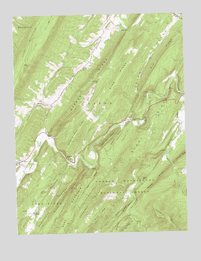
Baker, WV USGS Topographic Map
Click on map above to begin viewing in our Map Viewer.

This topographic map contains these locations and features:
Feature Name Type Latitude Longitude GNIS ID View Map
Arie Vankan SpringSpringN39.0332°W78.6267°1678082View Map
ArkansasPopulated PlaceN39.0746°W78.7292°1550114View Map
BakerPopulated PlaceN39.0418°W78.7447°1553778View Map
Baker Mine SpringSpringN39.0551°W78.7217°1678087View Map
Baker Post OfficePost OfficeN39.0408°W78.7468°1718536View Map
Baker RunStreamN39.0351°W78.7414°1550153View Map
Baker Run School (historical)SchoolN39.0409°W78.7489°1550154View Map
Bald KnobSummitN39.0971°W78.7428°1553789View Map
Baughman SettlementPopulated PlaceN39.0115°W78.7386°1553811View Map
Big RidgeRidgeN39.1104°W78.6322°1550307View Map
Big SpringSpringN39.0625°W78.6777°1678088View Map
Blue Sea GapGapN39.0437°W78.6456°1553560View Map
Breakneck RidgeRidgeN39.0118°W78.7264°1550452View Map
Brushy HollowValleyN39.0371°W78.6953°1550507View Map
Brushy Hollow TrailTrailN39.0318°W78.7028°1550508View Map
Camp HemlockLocaleN39.0465°W78.6400°1550602View Map
Camp PinnacleLocaleN39.0776°W78.6528°1550608View Map
Camp Pinnacle SpringSpringN39.0801°W78.6519°1678089View Map
Capon DistrictCivilN39.0671°W78.6813°1928178View Map
Cave ValleyBasinN39.0793°W78.6942°1550659View Map
Cave Valley Presbyterian ChurchChurchN39.0868°W78.6883°1550660View Map
Cherry RidgeRidgeN39.0029°W78.6758°1550685View Map
Chestnut RidgeRidgeN39.0171°W78.6956°1550699View Map
Devils Garden RidgeRidgeN39.0501°W78.6400°1553559View Map
Dutch HollowValleyN39.0654°W78.6636°1550998View Map
Ellis HollowValleyN39.0393°W78.6900°1551055View Map
Halfmoon MountainSummitN39.0009°W78.6317°1551324View Map
Halfmoon RunStreamN39.0448°W78.6381°1551326View Map
Hanging RockCliffN39.0440°W78.7125°1551350View Map
Hanging Rock RidgeRidgeN39.0576°W78.7050°1551352View Map
Hardy County Emergency AmbulanceBuildingN39.0474°W78.7371°2775488View Map
Heishman School (historical)SchoolN39.0523°W78.6345°1556842View Map
High Top RidgeRidgeN39.0529°W78.6822°1551438View Map
Landacre HollowValleyN39.0604°W78.6714°1551692View Map
Landecker Farm SpringSpringN39.0873°W78.6328°1678090View Map
Landecker School (historical)SchoolN39.1051°W78.6458°1556847View Map
Lost RiverStreamN39.0637°W78.6545°1551944View Map
Lost River Number 1 BridgeBridgeN39.0448°W78.7355°2646960View Map
Lost River Number 3 BridgeBridgeN39.0661°W78.6547°2646963View Map
Mathias - Baker Volunteer Emergency Squad - BakerBuildingN39.0476°W78.7369°2577783View Map
Mathias Baker Volunteer Emergency Squad 42BuildingN39.0476°W78.7373°2581210View Map
McCauleyPopulated PlaceN39.0423°W78.7120°1555076View Map
Miller SpringSpringN39.0454°W78.7075°1678086View Map
Mollys HillSummitN39.0309°W78.6575°1555145View Map
Mount Moriah ChurchChurchN39.0137°W78.7425°1552208View Map
National Forest SpringSpringN39.0373°W78.6745°1678085View Map
Pine RidgeRidgeN39.0896°W78.6722°1552485View Map
Pine Ridge School (historical)SchoolN39.0507°W78.6970°1556862View Map
Reed Farm SpringSpringN39.0220°W78.7207°1678084View Map
Rocky RidgeRidgeN39.0284°W78.6486°1552717View Map
Rudy Memorial BridgeBridgeN39.0419°W78.7116°2646961View Map
Sandy RidgeRidgeN39.0626°W78.6472°1552803View Map
Sauerkraut RunStreamN39.0643°W78.6636°1552805View Map
Sauerkraut Run BridgeBridgeN39.0658°W78.6637°2646962View Map
Shady Grove School (historical)SchoolN39.0190°W78.6720°1556869View Map
Short MountainSummitN39.0971°W78.7425°1555619View Map
Sperry Run ChurchChurchN39.0934°W78.6995°1547133View Map
Sperry Run School (historical)SchoolN39.0937°W78.7000°1556873View Map
Squirrel GapGapN39.0273°W78.6811°1553033View Map
Squirrel Gap TrailTrailN39.0468°W78.6842°1553034View Map
Steacy Conrad SpringSpringN39.1182°W78.6592°1678091View Map
Thorny BottomValleyN39.0237°W78.6678°1553221View Map
Thorny Bottom RidgeRidgeN39.0062°W78.6931°1553222View Map
Three Springs RunStreamN39.0393°W78.7089°1553231View Map
Trout Run Fault SpringSpringN39.0121°W78.6570°1678083View Map
Warden RidgeRidgeN39.0815°W78.6975°1553381View Map
Wildcat RidgeRidgeN39.0440°W78.6261°1553449View Map
Winfred Tharp SpringSpringN39.0357°W78.6342°1678081View Map
Wise GapGapN39.1162°W78.6658°1553491View Map
Zion Lutheran ChurchChurchN39.0743°W78.7297°1718593View Map

Note: Coordinates in the location and feature list above are referenced to NAD83 datum.


Copyright (C) 2008-2025 Ryan Niemi / Sunset Dynamics ... All Rights Reserved