TopoQuest Logo
Do you find TopoQuest useful?
Help keep TopoQuest running and adding new maps/features by donating!
Bitcoin:  19c7KJd3qBynnjoSw5npx9KScwjBe4ifkT
Litecoin:  LXs6TkuXGGXo1vDsWCkWVdjQX94eUKd6ui
Home View Maps Find Maps Find Places Resources & Links


Wardensville, West Virginia Topographic Map

USGS Map Title: Wardensville, WV
USGS Map MRC: 39078A5
DRG (GeoTIFF) Download: o39078a5.tif


Neighboring USGS Topographic Map Quads:


  Rio, WV  
39078B6
 

  Yellow Spring, WV  
39078B5
 

  Capon Springs, WV  
39078B4
 

  Baker, WV  
39078A6
 

  Wardensville, WV  
39078A5
 

  Mountain Falls, VA  
39078A4
 

  Wolf Gap, WV  
38078H6
 

  Woodstock, VA  
38078H5
 

  Toms Brook, VA  
38078H4


Map MRC Location:

N40°
W79°
N40°
W78°
H8 H7 H6 H5 H4 H3 H2 H1
G8 G7 G6 G5 G4 G3 G2 G1
F8 F7 F6 F5 F4 F3 F2 F1
E8 E7 E6 E5 E4 E3 E2 E1
D8 D7 D6 D5 D4 D3 D2 D1
C8 C7 C6 C5 C4 C3 C2 C1
B8 B7 B6 B5 B4 B3 B2 B1
A8 A7 A6 A5 A4 A3 A2 A1
N39°
W79°
N39°
W78°

Wardensville, WV USGS 1:24K Topographic Map Preview:
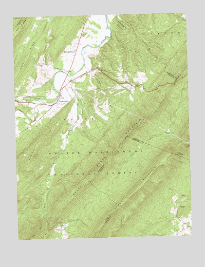
Wardensville, WV USGS Topographic Map
Click on map above to begin viewing in our Map Viewer.

This topographic map contains these locations and features:
Feature Name Type Latitude Longitude GNIS ID View Map
Alum-Bank CemeteryCemeteryN39.0945°W78.5914°1550100View Map
Anderson RidgeRidgeN39.0548°W78.6067°1550105View Map
Boiling SpringSpringN39.0212°W78.6053°1678139View Map
Bonnet HillSummitN39.0148°W78.5067°1481928View Map
Capon FurnaceLocaleN39.0301°W78.6061°1558346View Map
Capon Iron Works (historical)LocaleN39.0329°W78.6033°1718541View Map
Capon Valley Volunteer Fire DepartmentBuildingN39.0778°W78.5940°2577582View Map
Clagett CemeteryCemeteryN39.0976°W78.6036°1550715View Map
Cold SpringSpringN39.0779°W78.6206°1678136View Map
Cove RunStreamN39.0076°W78.5933°1550805View Map
Crest Hill ChurchChurchN39.1146°W78.5747°1550834View Map
Fowlers SpringSpringN39.0157°W78.5456°1797405View Map
Furnace (historical)Populated PlaceN39.0326°W78.6028°1556839View Map
Great North MountainRangeN39.0221°W78.5864°1483785View Map
Lower State Farm SpringSpringN39.1029°W78.5872°1678140View Map
Marvin ChapelChurchN39.0848°W78.5375°1552007View Map
Moores RunStreamN39.1034°W78.5758°1552184View Map
North Mountain School (historical)SchoolN39.0851°W78.5378°1556859View Map
Paddy MountainSummitN39.0068°W78.5633°1486030View Map
Paul Gerhart ShelterLocaleN39.0459°W78.5533°1488644View Map
Peewee SpringSpringN39.1245°W78.5720°1678138View Map
Pond RunStreamN39.0115°W78.6056°1552539View Map
Reymann Memorial Farms West Virginia UniversitySchoolN39.1059°W78.5808°1552637View Map
Richard Farm SpringSpringN39.0793°W78.5803°1678135View Map
Rocky RunStreamN39.0015°W78.5261°1782068View Map
Sine RunStreamN39.1173°W78.5545°1552900View Map
Slate Rock RunStreamN39.0971°W78.5739°1552922View Map
Slate Rock School (historical)SchoolN39.0834°W78.5622°1556871View Map
Three High HeadsCliffN39.0451°W78.5078°1487898View Map
Town of WardensvilleCivilN39.0768°W78.5932°2391468View Map
Trout RunStreamN39.0768°W78.5975°1553271View Map
Upper State Farm SpringSpringN39.0965°W78.5995°1678134View Map
Vances CoveBayN39.0579°W78.5153°1488108View Map
Waites RunStreamN39.0915°W78.5822°1553355View Map
WardensvillePopulated PlaceN39.0751°W78.5978°1553382View Map
Wardensville High School (historical)SchoolN39.0804°W78.5914°1718591View Map
Wardensville Police DepartmentBuildingN39.0800°W78.5913°2727939View Map
Wardensville Post OfficePost OfficeN39.0760°W78.5949°1718592View Map
Wardensville SpringSpringN39.0787°W78.5806°1678137View Map
Wardensville Volunteer Rescue SquadBuildingN39.0755°W78.5952°2581108View Map
Wilson CemeteryCemeteryN39.0682°W78.6161°1553476View Map
Wilson CoveBasinN39.0059°W78.5942°1553479View Map

Note: Coordinates in the location and feature list above are referenced to NAD83 datum.


Copyright (C) 2008-2025 Ryan Niemi / Sunset Dynamics ... All Rights Reserved