TopoQuest Logo
Do you find TopoQuest useful?
Help keep TopoQuest running and adding new maps/features by donating!
Bitcoin:  19c7KJd3qBynnjoSw5npx9KScwjBe4ifkT
Litecoin:  LXs6TkuXGGXo1vDsWCkWVdjQX94eUKd6ui
Home View Maps Find Maps Find Places Resources & Links


Rio, West Virginia Topographic Map

USGS Map Title: Rio, WV
USGS Map MRC: 39078B6
DRG (GeoTIFF) Download: o39078b6.tif


Neighboring USGS Topographic Map Quads:


  Romney, WV  
39078C7
 

  Augusta, WV  
39078C6
 

  Hanging Rock, WV  
39078C5
 

  Sector, WV  
39078B7
 

  Rio, WV  
39078B6
 

  Yellow Spring, WV  
39078B5
 

  Needmore, WV  
39078A7
 

  Baker, WV  
39078A6
 

  Wardensville, WV  
39078A5


Map MRC Location:

N40°
W79°
N40°
W78°
H8 H7 H6 H5 H4 H3 H2 H1
G8 G7 G6 G5 G4 G3 G2 G1
F8 F7 F6 F5 F4 F3 F2 F1
E8 E7 E6 E5 E4 E3 E2 E1
D8 D7 D6 D5 D4 D3 D2 D1
C8 C7 C6 C5 C4 C3 C2 C1
B8 B7 B6 B5 B4 B3 B2 B1
A8 A7 A6 A5 A4 A3 A2 A1
N39°
W79°
N39°
W78°

Rio, WV USGS 1:24K Topographic Map Preview:
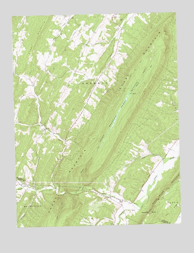
Rio, WV USGS Topographic Map
Click on map above to begin viewing in our Map Viewer.

This topographic map contains these locations and features:
Feature Name Type Latitude Longitude GNIS ID View Map
Bethel Baptist Church CemeteryCemeteryN39.1816°W78.7273°2726520View Map
Bethel Schoolhouse (historical)SchoolN39.1826°W78.7258°1718602View Map
Cove RunStreamN39.1451°W78.7111°1550806View Map
Deep RunStreamN39.1632°W78.6370°1538110View Map
Deep Run School (historical)SchoolN39.1637°W78.6372°1556757View Map
Denver School (historical)SchoolN39.2154°W78.6814°1556758View Map
Flat RidgeRidgeN39.1387°W78.6258°1551132View Map
Ford HillSummitN39.2462°W78.6681°1554481View Map
Gap Run SpringSpringN39.1334°W78.6464°1677921View Map
Grassy Lick CemeteryCemeteryN39.2097°W78.7342°2726588View Map
Grassy Lick Elementary School (historical)SchoolN39.1848°W78.7286°1539634View Map
Grassy Lick RunStreamN39.1487°W78.7186°1539633View Map
Heare CemeteryCemeteryN39.1801°W78.7192°1718651View Map
Hotts ChapelChurchN39.2090°W78.7350°1540520View Map
Hotts Chapel CemeteryCemeteryN39.2098°W78.7339°1718655View Map
Jerry Staggs Memorial BridgeBridgeN39.1257°W78.6763°2646971View Map
KirbyPopulated PlaceN39.1829°W78.7261°1554886View Map
Kirby Bethel Baptist ChurchChurchN39.1818°W78.7267°1535708View Map
Kirby Post OfficePost OfficeN39.1826°W78.7258°1718661View Map
Lutheran Ebenezer CemeteryCemeteryN39.1411°W78.6783°2726649View Map
Marshall School (historical)SchoolN39.1490°W78.7239°1556852View Map
Meadow RunStreamN39.1482°W78.6986°1543073View Map
Meadow SpringSpringN39.2279°W78.6372°1677922View Map
Mount Zion ChurchChurchN39.2479°W78.6728°1543836View Map
Mountaindale CemeteryCemeteryN39.2493°W78.7097°1718678View Map
Mountaindale ChurchChurchN39.2493°W78.7095°1543881View Map
North River Valley Volunteer Fire CompanyBuildingN39.1393°W78.6703°2577867View Map
Pot Lick RunStreamN39.1490°W78.7439°1545180View Map
Raymond Hawse SpringSpringN39.2295°W78.7458°1677923View Map
RioPopulated PlaceN39.1384°W78.6700°1545756View Map
Rio Elementary School (historical)SchoolN39.1390°W78.6697°1718698View Map
Rio Post OfficePost OfficeN39.1394°W78.6707°1718699View Map
Rock OakPopulated PlaceN39.1484°W78.7359°1555502View Map
RuckmanPopulated PlaceN39.2329°W78.6928°1556797View Map
Sherman DistrictCivilN39.2263°W78.6730°1928356View Map
Short Mountain Wildlife Management AreaParkN39.1926°W78.6697°1552880View Map
South MountainRangeN39.1668°W78.6664°587464View Map
Sperry RunStreamN39.1362°W78.6545°1552991View Map
Staacks GapGapN39.1320°W78.6492°1547299View Map
Sugar Grove School (historical)SchoolN39.2404°W78.7131°1556805View Map
Waterlick RunStreamN39.1468°W78.7345°1553389View Map
Watson School (historical)SchoolN39.2395°W78.6878°1556815View Map
Zoar ChurchChurchN39.2495°W78.6717°1549503View Map

Note: Coordinates in the location and feature list above are referenced to NAD83 datum.


Copyright (C) 2008-2025 Ryan Niemi / Sunset Dynamics ... All Rights Reserved