TopoQuest Logo
Do you find TopoQuest useful?
Help keep TopoQuest running and adding new maps/features by donating!
Bitcoin:  19c7KJd3qBynnjoSw5npx9KScwjBe4ifkT
Litecoin:  LXs6TkuXGGXo1vDsWCkWVdjQX94eUKd6ui
Home View Maps Find Maps Find Places Resources & Links


Needmore, West Virginia Topographic Map

USGS Map Title: Needmore, WV
USGS Map MRC: 39078A7
DRG (GeoTIFF) Download: o39078a7.tif


Neighboring USGS Topographic Map Quads:


  Old Fields, WV  
39078B8
 

  Sector, WV  
39078B7
 

  Rio, WV  
39078B6
 

  Moorefield, WV  
39078A8
 

  Needmore, WV  
39078A7
 

  Baker, WV  
39078A6
 

  Lost River State Park, WV  
38078H8
 

  Lost City, WV  
38078H7
 

  Wolf Gap, WV  
38078H6


Map MRC Location:

N40°
W79°
N40°
W78°
H8 H7 H6 H5 H4 H3 H2 H1
G8 G7 G6 G5 G4 G3 G2 G1
F8 F7 F6 F5 F4 F3 F2 F1
E8 E7 E6 E5 E4 E3 E2 E1
D8 D7 D6 D5 D4 D3 D2 D1
C8 C7 C6 C5 C4 C3 C2 C1
B8 B7 B6 B5 B4 B3 B2 B1
A8 A7 A6 A5 A4 A3 A2 A1
N39°
W79°
N39°
W78°

Needmore, WV USGS 1:24K Topographic Map Preview:
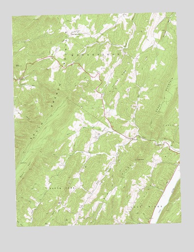
Needmore, WV USGS Topographic Map
Click on map above to begin viewing in our Map Viewer.

This topographic map contains these locations and features:
Feature Name Type Latitude Longitude GNIS ID View Map
Asbury ChurchChurchN39.1143°W78.8247°1550117View Map
Baker ChurchChurchN39.0471°W78.7672°1550151View Map
Baker Run School (historical)SchoolN39.0437°W78.7506°1556821View Map
Bean SettlementPopulated PlaceN39.1151°W78.8259°1553816View Map
Bears HellRidgeN39.0343°W78.8645°1550207View Map
Bears Hell RunStreamN39.0498°W78.7867°1550208View Map
Camp BranchStreamN39.0407°W78.7986°1550595View Map
Camp Branch School (historical)SchoolN39.0418°W78.8172°1556827View Map
Chestnut Cove School (historical)SchoolN39.1198°W78.8356°1556828View Map
Doman (historical)Populated PlaceN39.1107°W78.8103°1556833View Map
East Hardy Early Middle SchoolSchoolN39.0480°W78.7590°2088187View Map
East Hardy High SchoolSchoolN39.0472°W78.7606°2088188View Map
East Hardy Public LibraryBuildingN39.0478°W78.7610°2727219View Map
Evergreen ChurchChurchN39.0871°W78.8692°1551070View Map
Fabius (historical)Populated PlaceN39.0940°W78.8367°1556835View Map
Hardy CountyCivilN39.0075°W78.8579°1718557View Map
High RocksPillarN39.0384°W78.7822°1551437View Map
Hines School (historical)SchoolN39.0871°W78.8697°1556844View Map
Hunting RidgeRidgeN39.0857°W78.7925°1551531View Map
Lawn KnobSummitN39.0951°W78.8697°1551751View Map
Long Lick RunStreamN39.0532°W78.7820°1551922View Map
Long Lick Run BridgeBridgeN39.0554°W78.7812°2646964View Map
Long Lick School (historical)SchoolN39.0632°W78.7836°1556848View Map
Luxemburg School (historical)SchoolN39.1007°W78.7886°1556849View Map
Miller School (historical)SchoolN39.0004°W78.7809°1556854View Map
Mine Spring School (historical)SchoolN39.0079°W78.8309°1556855View Map
NeedmorePopulated PlaceN39.0507°W78.7867°1555194View Map
Parker HollowStreamN39.0493°W78.7878°1552432View Map
Parker HollowValleyN39.0498°W78.7867°1552433View Map
Phils Lick School (historical)SchoolN39.0704°W78.8745°1556861View Map
Pine Grove CemeteryCemeteryN39.0521°W78.8122°2586376View Map
Pine Grove ChurchChurchN39.0515°W78.8120°1552482View Map
Reynolds School (historical)SchoolN39.0215°W78.7678°1556866View Map
Salem ChurchChurchN39.0104°W78.8253°1552775View Map
Sand SpringSpringN39.0378°W78.8710°1552792View Map
Swartz RunStreamN39.0876°W78.8695°1553157View Map
Taylor HollowValleyN39.0673°W78.8722°1553183View Map
Webster SpringSpringN39.1126°W78.7692°1678111View Map

Note: Coordinates in the location and feature list above are referenced to NAD83 datum.


Copyright (C) 2008-2025 Ryan Niemi / Sunset Dynamics ... All Rights Reserved