TopoQuest Logo
Do you find TopoQuest useful?
Help keep TopoQuest running and adding new maps/features by donating!
Bitcoin:  19c7KJd3qBynnjoSw5npx9KScwjBe4ifkT
Litecoin:  LXs6TkuXGGXo1vDsWCkWVdjQX94eUKd6ui
Home View Maps Find Maps Find Places Resources & Links


Indian Peak, Arizona Topographic Map

USGS Map Title: Indian Peak, AZ
USGS Map MRC: 34112H7
DRG (GeoTIFF) Download: o34112h7.tif


Neighboring USGS Topographic Map Quads:


  Turkey Canyon, AZ  
35112A8
 

  Red Mountain, AZ  
35112A7
 

  South Butte, AZ  
35112A6
 

  Juniper Mountains, AZ  
34112H8
 

  Indian Peak, AZ  
34112H7
 

  Limestone Peak, AZ  
34112H6
 

  Camp Wood, AZ  
34112G8
 

  Seepage Mountain, AZ  
34112G7
 

  Simmons, AZ  
34112G6


Map MRC Location:

N35°
W113°
N35°
W112°
H8 H7 H6 H5 H4 H3 H2 H1
G8 G7 G6 G5 G4 G3 G2 G1
F8 F7 F6 F5 F4 F3 F2 F1
E8 E7 E6 E5 E4 E3 E2 E1
D8 D7 D6 D5 D4 D3 D2 D1
C8 C7 C6 C5 C4 C3 C2 C1
B8 B7 B6 B5 B4 B3 B2 B1
A8 A7 A6 A5 A4 A3 A2 A1
N34°
W113°
N34°
W112°

Indian Peak, AZ USGS 1:24K Topographic Map Preview:
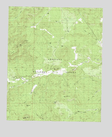
Indian Peak, AZ USGS Topographic Map
Click on map above to begin viewing in our Map Viewer.

This topographic map contains these locations and features:
Feature Name Type Latitude Longitude GNIS ID View Map
Apache CreekStreamN34.9200°W112.8449°25699View Map
Ash SpringSpringN34.8861°W112.8724°38233View Map
Bald MountainSummitN34.8786°W112.8496°33822View Map
Bald Mountain SpringSpringN34.8915°W112.8500°38238View Map
Brush TankReservoirN34.9930°W112.8244°38275View Map
Cement TankReservoirN34.9840°W112.8111°38325View Map
Chino Valley Ranger DistrictForestN34.8945°W112.8568°2038404View Map
Chucks TankReservoirN34.9575°W112.7552°41126View Map
Cienega RanchLocaleN34.9775°W112.8438°27639View Map
Flood Dam TankReservoirN34.9222°W112.8641°38447View Map
Fritche TankReservoirN34.9748°W112.7973°38455View Map
Graver WashStreamN34.9247°W112.8291°29554View Map
Hunt TankReservoirN34.9163°W112.8735°40978View Map
Indian HillSummitN34.9022°W112.7977°30345View Map
Indian PeakSummitN34.9325°W112.8113°30350View Map
Indian Spring Number ThreeSpringN34.8853°W112.7785°38529View Map
Indian SpringsSpringN34.8889°W112.7627°30373View Map
Juniper SpringSpringN34.9577°W112.8578°40974View Map
K Four RanchLocaleN34.9286°W112.8096°30815View Map
Section Twentyfive TankReservoirN34.9992°W112.8521°38792View Map
South TankReservoirN34.9605°W112.8210°40975View Map
Spur TankReservoirN34.9734°W112.8229°38841View Map
Taylor RanchLocaleN34.9211°W112.8624°35166View Map
Triangle U RanchLocaleN34.9128°W112.8360°35470View Map
Triangle U TankReservoirN34.8958°W112.8133°2039980View Map
Trick TankReservoirN34.9722°W112.7671°41127View Map
Walnut Creek Ranger StationLocaleN34.9236°W112.8430°35857View Map
Walnut Creek Work CenterLocaleN34.9225°W112.8552°38923View Map
Windshield TankReservoirN34.9322°W112.8401°40973View Map

Note: Coordinates in the location and feature list above are referenced to NAD83 datum.


Copyright (C) 2008-2024 Ryan Niemi / Sunset Dynamics ... All Rights Reserved