TopoQuest Logo
Do you find TopoQuest useful?
Help keep TopoQuest running and adding new maps/features by donating!
Bitcoin:  19c7KJd3qBynnjoSw5npx9KScwjBe4ifkT
Litecoin:  LXs6TkuXGGXo1vDsWCkWVdjQX94eUKd6ui
Home View Maps Find Maps Find Places Resources & Links


Seepage Mountain, Arizona Topographic Map

USGS Map Title: Seepage Mountain, AZ
USGS Map MRC: 34112G7
DRG (GeoTIFF) Download: o34112g7.tif


Neighboring USGS Topographic Map Quads:


  Juniper Mountains, AZ  
34112H8
 

  Indian Peak, AZ  
34112H7
 

  Limestone Peak, AZ  
34112H6
 

  Camp Wood, AZ  
34112G8
 

  Seepage Mountain, AZ  
34112G7
 

  Simmons, AZ  
34112G6
 

  Sheridan Mountain, AZ  
34112F8
 

  Smith Mesa, AZ  
34112F7
 

  Mount Josh, AZ  
34112F6


Map MRC Location:

N35°
W113°
N35°
W112°
H8 H7 H6 H5 H4 H3 H2 H1
G8 G7 G6 G5 G4 G3 G2 G1
F8 F7 F6 F5 F4 F3 F2 F1
E8 E7 E6 E5 E4 E3 E2 E1
D8 D7 D6 D5 D4 D3 D2 D1
C8 C7 C6 C5 C4 C3 C2 C1
B8 B7 B6 B5 B4 B3 B2 B1
A8 A7 A6 A5 A4 A3 A2 A1
N34°
W113°
N34°
W112°

Seepage Mountain, AZ USGS 1:24K Topographic Map Preview:
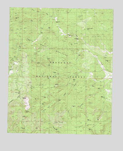
Seepage Mountain, AZ USGS Topographic Map
Click on map above to begin viewing in our Map Viewer.

This topographic map contains these locations and features:
Feature Name Type Latitude Longitude GNIS ID View Map
Brushy MountainSummitN34.8200°W112.8371°26836View Map
Brushy TankReservoirN34.8236°W112.8438°38278View Map
Cabin SpringSpringN34.7862°W112.8327°27151View Map
Cement Trough SpringSpringN34.7889°W112.8619°38326View Map
Colcord SpringSpringN34.7951°W112.7656°38349View Map
Cold Water TankReservoirN34.7712°W112.8541°38350View Map
Coop TankReservoirN34.7651°W112.7684°38363View Map
Cottonwood MountainSummitN34.7850°W112.8521°28025View Map
Cottonwood Wash SpringSpringN34.8548°W112.7823°38378View Map
Cross U RanchLocaleN34.8061°W112.7527°28187View Map
Dead Steer BasinBasinN34.8531°W112.8563°28331View Map
Denny MountainSummitN34.7672°W112.8538°41911View Map
Flat TopSummitN34.7847°W112.8413°38446View Map
Goat PeakSummitN34.8475°W112.8007°29361View Map
Hitt Wash WellWellN34.8320°W112.7549°38505View Map
Humphrey TankReservoirN34.7772°W112.7980°38524View Map
Hyde CreekStreamN34.8511°W112.8116°43092View Map
Hyde Creek SeepSpringN34.8642°W112.8685°38526View Map
Hyde SpringSpringN34.8550°W112.8289°38527View Map
Johnson MountainSummitN34.7989°W112.8149°30586View Map
Johnson PeakSummitN34.8242°W112.7582°30587View Map
Kckel SpringSpringN34.8264°W112.8674°38550View Map
Little Pine Creek WellWellN34.8109°W112.7777°38574View Map
Little Quail SpringSpringN34.8103°W112.8207°38577View Map
Mud SpringSpringN34.7811°W112.8268°32121View Map
North Tailholt TankReservoirN34.7625°W112.7793°38665View Map
Oak SpringSpringN34.8167°W112.8257°38670View Map
Parker SpringSpringN34.8497°W112.8373°32697View Map
Pine Creek SeepsSpringN34.8153°W112.8730°38693View Map
Pine SeepSpringN34.8362°W112.8634°38697View Map
Pole SpringSpringN34.8009°W112.7810°38707View Map
Prescott National ForestForestN34.8631°W112.8435°44655View Map
Red MountainSummitN34.8411°W112.7910°33484View Map
Red Mountain SpringSpringN34.8453°W112.7923°41907View Map
Rock SpringSpringN34.8300°W112.7952°33730View Map
Round Valley SpringSpringN34.8610°W112.8197°38767View Map
Round Valley WashStreamN34.8511°W112.8118°33838View Map
Sawmill TankReservoirN34.8057°W112.8262°38781View Map
Section Thirty SpringSpringN34.8246°W112.8297°38789View Map
Section Twenty-three TankReservoirN34.7553°W112.8547°38787View Map
Seepage MountainSummitN34.7620°W112.8188°34256View Map
Seepage TankReservoirN34.7528°W112.8166°38798View Map
South Tailholt TankReservoirN34.7542°W112.7760°38827View Map
Stringtown WashStreamN34.8259°W112.8674°34903View Map
Tailholt MesaSummitN34.7614°W112.7646°35114View Map
Tunnel SpringSpringN34.7631°W112.8382°38893View Map
Upper Tailholt SpringSpringN34.7836°W112.7688°38911View Map
West Sedona Elementary SchoolSchoolN34.8639°W112.7882°38937View Map
Whiskey SpringSpringN34.8042°W112.7980°41908View Map
Wickiup CanyonValleyN34.8106°W112.7827°36139View Map
Wickiup MesaSummitN34.7759°W112.8282°41910View Map
Wickiup Pit TankReservoirN34.7836°W112.8146°38943View Map
Wickiup SpringSpringN34.7840°W112.8154°41909View Map
Williamson Valley TankReservoirN34.8139°W112.8616°38956View Map
Windy Ridge SpringSpringN34.7717°W112.8563°38965View Map

Note: Coordinates in the location and feature list above are referenced to NAD83 datum.


Copyright (C) 2008-2024 Ryan Niemi / Sunset Dynamics ... All Rights Reserved