TopoQuest Logo
Do you find TopoQuest useful?
Help keep TopoQuest running and adding new maps/features by donating!
Bitcoin:  19c7KJd3qBynnjoSw5npx9KScwjBe4ifkT
Litecoin:  LXs6TkuXGGXo1vDsWCkWVdjQX94eUKd6ui
Home View Maps Find Maps Find Places Resources & Links


Indian Valley, Virginia Topographic Map

USGS Map Title: Indian Valley, VA
USGS Map MRC: 36080H5
DRG (GeoTIFF) Download: o36080h5.tif


Neighboring USGS Topographic Map Quads:


  Dublin, VA  
37080A6
 

  Radford South, VA  
37080A5
 

  Riner, VA  
37080A4
 

  Hiwassee, VA  
36080H6
 

  Indian Valley, VA  
36080H5
 

  Alum Ridge, VA  
36080H4
 

  Hillsville, VA  
36080G6
 

  Dugspur, VA  
36080G5
 

  Willis, VA  
36080G4


Map MRC Location:

N37°
W81°
N37°
W80°
H8 H7 H6 H5 H4 H3 H2 H1
G8 G7 G6 G5 G4 G3 G2 G1
F8 F7 F6 F5 F4 F3 F2 F1
E8 E7 E6 E5 E4 E3 E2 E1
D8 D7 D6 D5 D4 D3 D2 D1
C8 C7 C6 C5 C4 C3 C2 C1
B8 B7 B6 B5 B4 B3 B2 B1
A8 A7 A6 A5 A4 A3 A2 A1
N36°
W81°
N36°
W80°

Indian Valley, VA USGS 1:24K Topographic Map Preview:
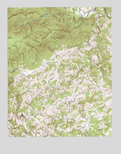
Indian Valley, VA USGS Topographic Map
Click on map above to begin viewing in our Map Viewer.

This topographic map contains these locations and features:
Feature Name Type Latitude Longitude GNIS ID View Map
Barrys CreekStreamN36.8901°W80.6120°1462816View Map
Bench MountainSummitN36.9821°W80.5881°1463071View Map
Bethel ChapelChurchN36.8776°W80.5373°1463155View Map
Big Indian CreekStreamN36.9960°W80.5226°1463363View Map
Big Laurel CreekStreamN36.9971°W80.5384°1463372View Map
Big Sand CemeteryCemeteryN36.9360°W80.5301°1463405View Map
Big Tan Trough BranchStreamN36.9898°W80.5334°1463421View Map
Buck Hollow BranchStreamN36.9673°W80.5809°1463983View Map
Buck Hollow RidgeRidgeN36.9740°W80.5820°1463985View Map
Camp BranchStreamN36.8815°W80.5326°1464310View Map
CampsitesLocaleN36.9940°W80.5776°1464383View Map
Christian MissionChurchN36.9504°W80.5251°1464893View Map
Copper ValleyLocaleN36.9910°W80.5167°1465235View Map
Copper Valley ChurchChurchN36.9812°W80.5148°1465236View Map
DeHart MountainSummitN36.9835°W80.5245°1493845View Map
Fire TrailTrailN36.9548°W80.6001°1466574View Map
Floyd County Life Saving and First Aid Squad Station 4BuildingN36.9079°W80.5578°2721178View Map
Floyd County Volunteer Fire Department 4BuildingN36.9082°W80.5448°2086319View Map
Greasy CreekStreamN36.8754°W80.6134°1467415View Map
Gum StandGapN36.9629°W80.6190°1467604View Map
Indian Creek ChurchChurchN36.9065°W80.5398°1468470View Map
Indian ValleyPopulated PlaceN36.9087°W80.5520°1468492View Map
Indian Valley ChurchChurchN36.9146°W80.5840°1468493View Map
Indian Valley ChurchChurchN36.9351°W80.6062°1468494View Map
Indian Valley DistrictCivilN36.9334°W80.5142°1927347View Map
Indian Valley Elementary SchoolSchoolN36.9165°W80.5393°1468495View Map
Indian Valley Post OfficePost OfficeN36.9092°W80.5520°2766227View Map
Little Indian CreekStreamN36.9740°W80.5178°1469567View Map
Little Laurel CreekStreamN36.9918°W80.5562°1469581View Map
Mira ForkStreamN36.8793°W80.5792°1470623View Map
Mitchell Chapel (historical)ChurchN36.8774°W80.5726°1494370View Map
Moore CemeteryCemeteryN36.8754°W80.6170°1738817View Map
North Fork Greasy CreekStreamN36.8804°W80.5145°1471606View Map
Ottari LakeReservoirN36.9917°W80.5786°1490766View Map
Ottari Scout Camp Number Two DamDamN36.9918°W80.5781°1490765View Map
Quesenberry CemeteryCemeteryN36.9185°W80.5976°1472903View Map
Rans CreekStreamN36.8904°W80.6048°1472973View Map
Shady BranchStreamN36.8840°W80.5451°1474197View Map
Tade Quesenberry CemeteryCemeteryN36.8807°W80.5962°1738917View Map
Union ChurchChurchN36.9215°W80.5878°1476040View Map
West Fork Big Indian CreekStreamN36.9465°W80.5203°1474293View Map

Note: Coordinates in the location and feature list above are referenced to NAD83 datum.


Copyright (C) 2008-2024 Ryan Niemi / Sunset Dynamics ... All Rights Reserved