TopoQuest Logo
Do you find TopoQuest useful?
Help keep TopoQuest running and adding new maps/features by donating!
Bitcoin:  19c7KJd3qBynnjoSw5npx9KScwjBe4ifkT
Litecoin:  LXs6TkuXGGXo1vDsWCkWVdjQX94eUKd6ui
Home View Maps Find Maps Find Places Resources & Links


Willis, Virginia Topographic Map

USGS Map Title: Willis, VA
USGS Map MRC: 36080G4
DRG (GeoTIFF) Download: o36080g4.tif


Neighboring USGS Topographic Map Quads:


  Indian Valley, VA  
36080H5
 

  Alum Ridge, VA  
36080H4
 

  Floyd, VA  
36080H3
 

  Dugspur, VA  
36080G5
 

  Willis, VA  
36080G4
 

  Woolwine, VA  
36080G3
 

  Laurel Fork, VA  
36080F5
 

  Meadows of Dan, VA  
36080F4
 

  Stuart, VA  
36080F3


Map MRC Location:

N37°
W81°
N37°
W80°
H8 H7 H6 H5 H4 H3 H2 H1
G8 G7 G6 G5 G4 G3 G2 G1
F8 F7 F6 F5 F4 F3 F2 F1
E8 E7 E6 E5 E4 E3 E2 E1
D8 D7 D6 D5 D4 D3 D2 D1
C8 C7 C6 C5 C4 C3 C2 C1
B8 B7 B6 B5 B4 B3 B2 B1
A8 A7 A6 A5 A4 A3 A2 A1
N36°
W81°
N36°
W80°

Willis, VA USGS 1:24K Topographic Map Preview:
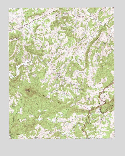
Willis, VA USGS Topographic Map
Click on map above to begin viewing in our Map Viewer.

This topographic map contains these locations and features:
Feature Name Type Latitude Longitude GNIS ID View Map
Black RidgeRidgeN36.8399°W80.3995°1463502View Map
Blue Ridge ChurchChurchN36.8429°W80.4620°1463584View Map
Buffalo BranchStreamN36.7687°W80.4659°1464026View Map
Buffalo MountainSummitN36.7960°W80.4770°1464045View Map
Buffalo RidgeRidgeN36.7862°W80.4473°1464048View Map
Burks Fork ChurchChurchN36.8112°W80.4412°1464118View Map
Burks Fork DistrictCivilN36.8342°W80.4368°1927123View Map
Conners GrovePopulated PlaceN36.7965°W80.4181°1499295View Map
Conners Grove Baptist ChurchChurchN36.7974°W80.4184°1494349View Map
East Prong Furnace CreekStreamN36.8462°W80.3798°1466116View Map
Floyd County Volunteer Fire Department 2BuildingN36.8608°W80.4812°2721090View Map
Furnace CreekStreamN36.8579°W80.3870°1466928View Map
Green Mountain ChurchChurchN36.7504°W80.4687°1467480View Map
Harris ChapelChurchN36.7979°W80.4181°1467775View Map
Hog MountainSummitN36.7876°W80.4062°1468108View Map
Jones MountainSummitN36.8032°W80.3909°1499611View Map
Long MountainSummitN36.7890°W80.4795°1499686View Map
Long Mountain CreekStreamN36.7512°W80.4978°1469824View Map
Mabry MillPopulated PlaceN36.7501°W80.4048°1500069View Map
Mabry Mill PondReservoirN36.7528°W80.4064°1489771View Map
Mabry Mill Pond DamDamN36.7535°W80.4065°1489770View Map
Oldfield CreekStreamN36.7682°W80.4595°1471890View Map
Parkway ChurchChurchN36.7657°W80.4234°1472076View Map
Reeds CreekStreamN36.8657°W80.4034°1486560View Map
Rock Castle GapGapN36.7757°W80.3917°1473356View Map
Rush ForkStreamN36.8576°W80.3870°1473640View Map
Saint Mark Lutheran ChurchChurchN36.8571°W80.4831°1494374View Map
Shelor CemeteryCemeteryN36.7668°W80.4342°1494375View Map
Skyline ChurchChurchN36.7935°W80.3881°1474661View Map
Slate MountainSummitN36.7765°W80.4140°1500119View Map
Slate Mountain ChurchChurchN36.7782°W80.3923°1474672View Map
Topeco ChurchChurchN36.8668°W80.4156°1475785View Map
UnionPopulated PlaceN36.8104°W80.4417°1477828View Map
Union ChurchChurchN36.8232°W80.4515°1476039View Map
West Prong Furnace CreekStreamN36.8462°W80.3798°1476503View Map
WillisPopulated PlaceN36.8579°W80.4809°1500324View Map
Willis Elementary SchoolSchoolN36.8632°W80.4662°1476787View Map
Willis Post OfficePost OfficeN36.8582°W80.4824°2766322View Map
Willis United Methodist ChurchChurchN36.8565°W80.4837°1494378View Map

Note: Coordinates in the location and feature list above are referenced to NAD83 datum.


Copyright (C) 2008-2024 Ryan Niemi / Sunset Dynamics ... All Rights Reserved