TopoQuest Logo
Do you find TopoQuest useful?
Help keep TopoQuest running and adding new maps/features by donating!
Bitcoin:  19c7KJd3qBynnjoSw5npx9KScwjBe4ifkT
Litecoin:  LXs6TkuXGGXo1vDsWCkWVdjQX94eUKd6ui
Home View Maps Find Maps Find Places Resources & Links


Lacour, Louisiana Topographic Map

USGS Map Title: Lacour, LA
USGS Map MRC: 30091G5
DRG (GeoTIFF) Download: o30091g5.tif


Neighboring USGS Topographic Map Quads:


  Innis, LA  
30091H6
 

  Angola, LA  
30091H5
 

  Weyanoke, LA  
30091H4
 

  Batchelor, LA  
30091G6
 

  Lacour, LA  
30091G5
 

  Saint Francisville, LA  
30091G4
 

  Melville, LA  
30091F6
 

  Morganza, LA  
30091F5
 

  New Roads, LA  
30091F4


Map MRC Location:

N31°
W92°
N31°
W91°
H8 H7 H6 H5 H4 H3 H2 H1
G8 G7 G6 G5 G4 G3 G2 G1
F8 F7 F6 F5 F4 F3 F2 F1
E8 E7 E6 E5 E4 E3 E2 E1
D8 D7 D6 D5 D4 D3 D2 D1
C8 C7 C6 C5 C4 C3 C2 C1
B8 B7 B6 B5 B4 B3 B2 B1
A8 A7 A6 A5 A4 A3 A2 A1
N30°
W92°
N30°
W91°

Lacour, LA USGS 1:24K Topographic Map Preview:
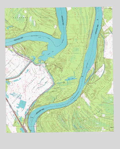
Lacour, LA USGS Topographic Map
Click on map above to begin viewing in our Map Viewer.

This topographic map contains these locations and features:
Feature Name Type Latitude Longitude GNIS ID View Map
Bay LakeLakeN30.8183°W91.5895°553385View Map
Bayou Dam LandingLocaleN30.8143°W91.5348°549430View Map
Bayou DanStreamN30.7788°W91.5698°532555View Map
Blind BayouGutN30.8224°W91.5112°533214View Map
Blue BayouStreamN30.7893°W91.5923°533231View Map
Brownville (historical)Populated PlaceN30.7835°W91.5898°549433View Map
Brunette PointCapeN30.7824°W91.5551°533447View Map
Brunette Point RevetmentLeveeN30.8160°W91.5346°549435View Map
Bundy LakeLakeN30.8558°W91.6206°553833View Map
Cane RidgeRidgeN30.8043°W91.5018°533717View Map
Cat Island National Wildlife RefugeParkN30.7561°W91.5249°2765234View Map
Catfish LandingLocaleN30.7705°W91.5812°550169View Map
Cowhead BayouStreamN30.7705°W91.6079°534215View Map
Greenwood Bend RevetmentLeveeN30.8624°W91.5121°550176View Map
Greenwood LandingLocaleN30.8677°W91.5118°550177View Map
Iowa PointCapeN30.7571°W91.5898°535942View Map
Iowa Point LandingLocaleN30.7757°W91.5571°550179View Map
Iowa Point RevetmentLeveeN30.7743°W91.5637°550180View Map
Jerusalem School (historical)SchoolN30.8232°W91.5093°550181View Map
Kellers SloughGutN30.7993°W91.5618°536156View Map
Killarny Farm Airport (historical)AirportN30.8410°W91.5082°1632932View Map
LacourPopulated PlaceN30.8282°W91.6140°554963View Map
Lacour PlantationLocaleN30.8202°W91.6132°549445View Map
Little IslandIslandN30.8082°W91.5157°536566View Map
Little Rock CemeteryCemeteryN30.8035°W91.5746°549446View Map
Little Rock Church (historical)ChurchN30.8018°W91.5718°549447View Map
Little Rock School (historical)SchoolN30.8016°W91.5718°549448View Map
Monday LakeLakeN30.8371°W91.5615°555349View Map
Morganza SpillwayDamN30.7774°W91.6200°537215View Map
Mount Olive CemeteryCemeteryN30.8213°W91.5957°549456View Map
Mount Olive ChurchChurchN30.8216°W91.5962°537354View Map
Mount Olive Church (historical)ChurchN30.8077°W91.5118°550189View Map
Mount Zion CemeteryCemeteryN30.8352°W91.6201°549457View Map
Mount Zion ChurchChurchN30.8352°W91.6207°537437View Map
New Jerusalem ChurchChurchN30.8235°W91.5093°554875View Map
New Texas LandingLocaleN30.7735°W91.5934°549458View Map
Pauls SloughGutN30.8149°W91.5651°538025View Map
Pays BayouStreamN30.7893°W91.5926°538027View Map
Raccourci (historical)Populated PlaceN30.7871°W91.5865°549465View Map
Ryans LandingLocaleN30.7677°W91.5982°549468View Map
Saint Francisville Gas FieldOilfieldN30.7668°W91.5112°550193View Map
Sebastopol LandingLocaleN30.7891°W91.5457°549475View Map
Shaw LakeLakeN30.8026°W91.5508°556016View Map
Star Light Church (historical)ChurchN30.7538°W91.6034°549477View Map
Stouts BayouStreamN30.8505°W91.5979°539683View Map
Tunica IslandIslandN30.8260°W91.5143°540023View Map

Note: Coordinates in the location and feature list above are referenced to NAD83 datum.


Copyright (C) 2008-2024 Ryan Niemi / Sunset Dynamics ... All Rights Reserved