TopoQuest Logo
Do you find TopoQuest useful?
Help keep TopoQuest running and adding new maps/features by donating!
Bitcoin:  19c7KJd3qBynnjoSw5npx9KScwjBe4ifkT
Litecoin:  LXs6TkuXGGXo1vDsWCkWVdjQX94eUKd6ui
Home View Maps Find Maps Find Places Resources & Links


Irondale, Missouri Topographic Map

USGS Map Title: Irondale, MO
USGS Map MRC: 37090G6
DRG (GeoTIFF) Download: o37090g6.tif


Neighboring USGS Topographic Map Quads:


  Potosi, MO  
37090H7
 

  Mineral Point, MO  
37090H6
 

  Bonne Terre, MO  
37090H5
 

  Belgrade, MO  
37090G7
 

  Irondale, MO  
37090G6
 

  Flat River, MO  
37090G5
 

  Banner, MO  
37090F7
 

  Graniteville, MO  
37090F6
 

  Iron Mountain Lake, MO  
37090F5


Map MRC Location:

N38°
W91°
N38°
W90°
H8 H7 H6 H5 H4 H3 H2 H1
G8 G7 G6 G5 G4 G3 G2 G1
F8 F7 F6 F5 F4 F3 F2 F1
E8 E7 E6 E5 E4 E3 E2 E1
D8 D7 D6 D5 D4 D3 D2 D1
C8 C7 C6 C5 C4 C3 C2 C1
B8 B7 B6 B5 B4 B3 B2 B1
A8 A7 A6 A5 A4 A3 A2 A1
N37°
W91°
N37°
W90°

Irondale, MO USGS 1:24K Topographic Map Preview:
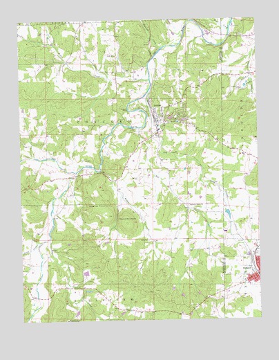
Irondale, MO USGS Topographic Map
Click on map above to begin viewing in our Map Viewer.

This topographic map contains these locations and features:
Feature Name Type Latitude Longitude GNIS ID View Map
Adams PropertyMineN37.7803°W90.7035°736851View Map
Alum Cave Methodist Church (historical)ChurchN37.7648°W90.7235°736852View Map
Alum Cave School (historical)SchoolN37.7609°W90.7343°736857View Map
Big River CemeteryCemeteryN37.8092°W90.6882°714201View Map
Bismarck Fire DepartmentBuildingN37.7699°W90.6263°2620872View Map
Bismarck Masonic CemeteryCemeteryN37.7820°W90.6255°2702949View Map
Bismarck Rural Fire Protection AssociationBuildingN37.7699°W90.6262°2620873View Map
Blay CreekStreamN37.8701°W90.6390°755789View Map
Camp IrondaleLocaleN37.8331°W90.6682°736285View Map
Cates Lake DamDamN37.7684°W90.7151°763720View Map
Cedar CreekStreamN37.8117°W90.7210°749288View Map
City of IrondaleCivilN37.8356°W90.6718°2395437View Map
Davis CemeteryCemeteryN37.7642°W90.7235°716714View Map
Dry CreekStreamN37.8471°W90.6808°756002View Map
Eaton Iron BankMineN37.8528°W90.7007°736850View Map
Evans MineMineN37.8603°W90.6996°717673View Map
Eversole MineMineN37.8170°W90.7176°717697View Map
Goose CreekStreamN37.7828°W90.7393°750083View Map
Hayden CreekStreamN37.8623°W90.6251°756166View Map
Hayden Creek MineMineN37.8456°W90.6335°756167View Map
Hazel Glen School (historical)SchoolN37.8214°W90.7360°736855View Map
Hickory Grove CemeteryCemeteryN37.7984°W90.6618°1759797View Map
Hickory Grove ChurchChurchN37.7975°W90.6621°719462View Map
Hickory Grove School (historical)SchoolN37.7967°W90.6618°736856View Map
Hill View Lake Dam SouthDamN37.7500°W90.7085°765039View Map
Hillview LakeReservoirN37.7533°W90.7215°764299View Map
Hillview Lake DamDamN37.7550°W90.7201°764298View Map
Hopewell CreekStreamN37.8634°W90.6749°719810View Map
Hughes CemeteryCemeteryN37.8081°W90.7001°1851847View Map
Hughes CreekStreamN37.8020°W90.6971°736848View Map
Hughes Mill (historical)LocaleN37.8087°W90.7015°736849View Map
Hughes MountainSummitN37.8020°W90.7098°719976View Map
IrondalePopulated PlaceN37.8320°W90.6782°736310View Map
Irondale Community Volunteer Fire DepartmentBuildingN37.8332°W90.6752°2620379View Map
Irondale LakeReservoirN37.8306°W90.6932°735970View Map
Irondale MineMineN37.8378°W90.6937°720168View Map
Irondale Post OfficePost OfficeN37.8332°W90.6774°2782968View Map
Kirkpatrick Iron BankMineN37.8337°W90.7201°736847View Map
Lake ApacheReservoirN37.8343°W90.6705°764543View Map
Lake Apache DamDamN37.8334°W90.6718°764542View Map
Lake CherokeeReservoirN37.8334°W90.6636°764590View Map
Lake Cherokee DamDamN37.8334°W90.6651°764589View Map
Lake SacajaweaReservoirN37.7699°W90.7165°763721View Map
Lost CreekStreamN37.7846°W90.7349°740001View Map
MarydenLocaleN37.7964°W90.6626°735975View Map
McCormack FordLocaleN37.8381°W90.6932°736846View Map
Mill CreekStreamN37.8295°W90.6873°736324View Map
Red RockLocaleN37.8020°W90.7098°736845View Map
Rock Spring School (historical)SchoolN37.8564°W90.7110°736854View Map
Round MountainSummitN37.7906°W90.6948°725608View Map
Scott Iron BankMineN37.8300°W90.7010°736843View Map
Sherlock School (historical)SchoolN37.7525°W90.6640°736853View Map
Township of BellevueCivilN37.7658°W90.7480°767506View Map
Township of ConcordCivilN37.8278°W90.7102°767508View Map
Wallen CemeteryCemeteryN37.7834°W90.6837°728285View Map
Wallen CreekStreamN37.8131°W90.7079°728286View Map
Wallen CreekStreamN37.8500°W90.6818°752738View Map
Yacovelli Lake DamDamN37.7951°W90.6418°764940View Map

Note: Coordinates in the location and feature list above are referenced to NAD83 datum.


Copyright (C) 2008-2025 Ryan Niemi / Sunset Dynamics ... All Rights Reserved