TopoQuest Logo
Do you find TopoQuest useful?
Help keep TopoQuest running and adding new maps/features by donating!
Bitcoin:  19c7KJd3qBynnjoSw5npx9KScwjBe4ifkT
Litecoin:  LXs6TkuXGGXo1vDsWCkWVdjQX94eUKd6ui
Home View Maps Find Maps Find Places Resources & Links


Graniteville, Missouri Topographic Map

USGS Map Title: Graniteville, MO
USGS Map MRC: 37090F6
DRG (GeoTIFF) Download: o37090f6.tif


Neighboring USGS Topographic Map Quads:


  Belgrade, MO  
37090G7
 

  Irondale, MO  
37090G6
 

  Flat River, MO  
37090G5
 

  Banner, MO  
37090F7
 

  Graniteville, MO  
37090F6
 

  Iron Mountain Lake, MO  
37090F5
 

  Johnson Shut-ins, MO  
37090E7
 

  Ironton, MO  
37090E6
 

  Lake Killarney, MO  
37090E5


Map MRC Location:

N38°
W91°
N38°
W90°
H8 H7 H6 H5 H4 H3 H2 H1
G8 G7 G6 G5 G4 G3 G2 G1
F8 F7 F6 F5 F4 F3 F2 F1
E8 E7 E6 E5 E4 E3 E2 E1
D8 D7 D6 D5 D4 D3 D2 D1
C8 C7 C6 C5 C4 C3 C2 C1
B8 B7 B6 B5 B4 B3 B2 B1
A8 A7 A6 A5 A4 A3 A2 A1
N37°
W91°
N37°
W90°

Graniteville, MO USGS 1:24K Topographic Map Preview:
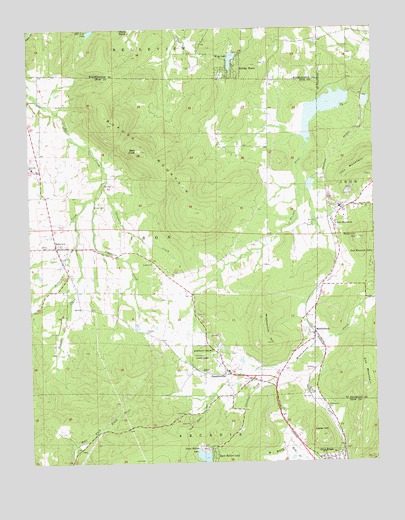
Graniteville, MO USGS Topographic Map
Click on map above to begin viewing in our Map Viewer.

This topographic map contains these locations and features:
Feature Name Type Latitude Longitude GNIS ID View Map
Bald KnobSummitN37.7148°W90.7090°713588View Map
BelleviewPopulated PlaceN37.6875°W90.7404°736276View Map
Belleview CreekStreamN37.7048°W90.7226°748777View Map
Belleview SchoolSchoolN37.7100°W90.7487°713928View Map
Black Lower Lake DamDamN37.7300°W90.6268°765081View Map
Black Upper Lake DamDamN37.7251°W90.6251°764883View Map
Buford MountainSummitN37.6970°W90.6893°715018View Map
Buzzards RoostSummitN37.6650°W90.6857°736628View Map
Cedar HillSummitN37.6325°W90.6451°715601View Map
Cedar Hill Iron MineMineN37.6342°W90.6498°736627View Map
Chambers CreekStreamN37.7048°W90.7226°715708View Map
Charles CreekStreamN37.6517°W90.6598°715742View Map
Edison CemeteryCemeteryN37.6998°W90.7235°717405View Map
Elephant Rocks State ParkParkN37.6545°W90.6882°717441View Map
Elm Grove School (historical)SchoolN37.7148°W90.7451°742712View Map
First CreekStreamN37.7037°W90.6521°757924View Map
GhermanvillePopulated PlaceN37.6489°W90.6701°736626View Map
GranitevillePopulated PlaceN37.6503°W90.6798°718694View Map
Hematite Lake DamDamN37.7313°W90.6337°763556View Map
Hill View LakeReservoirN37.7490°W90.7272°719608View Map
Holiday ShoresPopulated PlaceN37.7392°W90.6746°719704View Map
Iron MountainPopulated PlaceN37.6953°W90.6404°756212View Map
Iron MountainSummitN37.7116°W90.6263°756213View Map
Iron Mountain CemeteryCemeteryN37.6923°W90.6373°2702962View Map
Iron Mountain ReservoirReservoirN37.6896°W90.6308°2563282View Map
Iron Mountain SchoolSchoolN37.6956°W90.6360°757925View Map
Iron Mountain Tailings PondReservoirN37.7049°W90.6484°764099View Map
Iron Mountain Tailings Pond DamDamN37.7067°W90.6485°764098View Map
Link CemeteryCemeteryN37.6259°W90.7098°721115View Map
Little Iron MountainSummitN37.7081°W90.6348°757926View Map
Logan CreekStreamN37.7009°W90.7260°721420View Map
LopezPopulated PlaceN37.6520°W90.6465°756328View Map
MiddlebrookPopulated PlaceN37.6628°W90.6484°756387View Map
Middlebrook HillSummitN37.6592°W90.6646°722292View Map
Oak MountainSummitN37.6473°W90.6271°756467View Map
Ozark Ore Company LakeReservoirN37.7267°W90.6431°763557View Map
Phil Schneider Granite QuarriesMineN37.6631°W90.7032°736625View Map
Pilot Knob CemeteryCemeteryN37.6409°W90.6434°724353View Map
Pilot Knob Fire Protection District Station 2 BelleviewBuildingN37.6870°W90.7404°2620899View Map
Pilot Knob Granite QuarryMineN37.6359°W90.6932°736623View Map
Pin HookPopulated PlaceN37.6792°W90.7360°736624View Map
Reservoir HillSummitN37.6892°W90.6310°756575View Map
Schneider Companys QuarryMineN37.6667°W90.6885°736630View Map
Sheahan Brothers Granite QuarryMineN37.6514°W90.6879°736622View Map
Sky Ranch II Airport (historical)AirportN37.6792°W90.7154°758583View Map
Snow Hollow DamDamN37.6250°W90.6868°764070View Map
Snow Hollow LakeReservoirN37.6269°W90.6881°758341View Map
Snow Hollow LakePopulated PlaceN37.6289°W90.6854°726674View Map
Stony PointSummitN37.7495°W90.7160°727149View Map
Syenite Granite Companys QuarryMineN37.6617°W90.6826°736629View Map
Thomas CemeteryCemeteryN37.6628°W90.7085°727579View Map
Thorn Grove School (historical)SchoolN37.6856°W90.7110°742713View Map
Townsen CreekStreamN37.6878°W90.7332°727744View Map
Township of IronCivilN37.6907°W90.7337°766795View Map
Wing LakeReservoirN37.7408°W90.6764°758361View Map
Wing Lake DamDamN37.7417°W90.6768°764531View Map

Note: Coordinates in the location and feature list above are referenced to NAD83 datum.


Copyright (C) 2008-2025 Ryan Niemi / Sunset Dynamics ... All Rights Reserved