TopoQuest Logo
Do you find TopoQuest useful?
Help keep TopoQuest running and adding new maps/features by donating!
Bitcoin:  19c7KJd3qBynnjoSw5npx9KScwjBe4ifkT
Litecoin:  LXs6TkuXGGXo1vDsWCkWVdjQX94eUKd6ui
Home View Maps Find Maps Find Places Resources & Links


Iron Mountain Lake, Missouri Topographic Map

USGS Map Title: Iron Mountain Lake, MO
USGS Map MRC: 37090F5
DRG (GeoTIFF) Download: o37090f5.tif


Neighboring USGS Topographic Map Quads:


  Irondale, MO  
37090G6
 

  Flat River, MO  
37090G5
 

  Farmington, MO  
37090G4
 

  Graniteville, MO  
37090F6
 

  Iron Mountain Lake, MO  
37090F5
 

  Wachita Mountain, MO  
37090F4
 

  Ironton, MO  
37090E6
 

  Lake Killarney, MO  
37090E5
 

  Rhodes Mountain, MO  
37090E4


Map MRC Location:

N38°
W91°
N38°
W90°
H8 H7 H6 H5 H4 H3 H2 H1
G8 G7 G6 G5 G4 G3 G2 G1
F8 F7 F6 F5 F4 F3 F2 F1
E8 E7 E6 E5 E4 E3 E2 E1
D8 D7 D6 D5 D4 D3 D2 D1
C8 C7 C6 C5 C4 C3 C2 C1
B8 B7 B6 B5 B4 B3 B2 B1
A8 A7 A6 A5 A4 A3 A2 A1
N37°
W91°
N37°
W90°

Iron Mountain Lake, MO USGS 1:24K Topographic Map Preview:
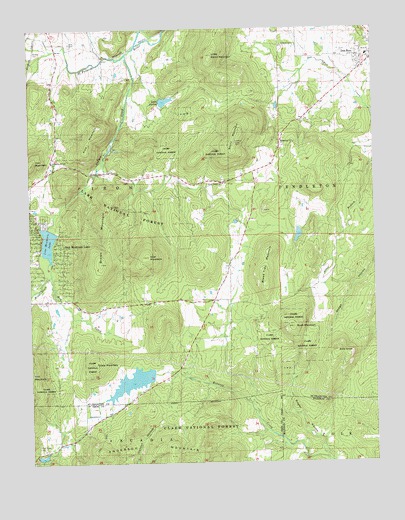
Iron Mountain Lake, MO USGS Topographic Map
Click on map above to begin viewing in our Map Viewer.

This topographic map contains these locations and features:
Feature Name Type Latitude Longitude GNIS ID View Map
Anderson MountainSummitN37.6284°W90.5996°748590View Map
Assembly of God ChurchChurchN37.7120°W90.6168°755703View Map
Bald KnobSummitN37.6570°W90.5143°755718View Map
Bethel German Methodist Episcopal Church (historical)ChurchN37.7448°W90.5282°757928View Map
Bread Tray MountainSummitN37.6778°W90.5398°755810View Map
Brown MountainSummitN37.6826°W90.5990°755821View Map
Buck MountainSummitN37.6639°W90.5298°755830View Map
City of Iron Mountain LakeCivilN37.6854°W90.6185°2395436View Map
Dent CemeteryCemeteryN37.7459°W90.6096°755984View Map
Doe Run Lead MinesMineN37.7434°W90.5012°757937View Map
Dove AirstripAirportN37.6689°W90.6129°758589View Map
German CemeteryCemeteryN37.7453°W90.5276°756091View Map
Grieder CemeteryCemeteryN37.7434°W90.6233°756134View Map
Indian CreekStreamN37.7428°W90.5887°756211View Map
Iron Mountain LakePopulated PlaceN37.6931°W90.6226°756214View Map
Iron Mountain LakeReservoirN37.6889°W90.6185°756215View Map
Iron Mountain Lake DamDamN37.6928°W90.6187°763647View Map
King School (historical)SchoolN37.6714°W90.5587°757077View Map
KTJJ-FM (Farmington)TowerN37.7187°W90.5504°759102View Map
Lake 2 DamDamN37.6267°W90.6235°764306View Map
Lake AvalonReservoirN37.7293°W90.5755°758247View Map
Lake Avalon DamDamN37.7301°W90.5768°764035View Map
Lake Number 1 DamDamN37.6517°W90.5801°764036View Map
Little Stono MountainSummitN37.7423°W90.5573°756317View Map
Magee HollowValleyN37.6289°W90.5198°756339View Map
Middlebrook CreekStreamN37.6795°W90.6173°756388View Map
Mineral CityPopulated PlaceN37.7164°W90.5337°756396View Map
Mud CreekStreamN37.6795°W90.6173°756430View Map
Pilot Knob CemeteryCemeteryN37.6289°W90.6207°751594View Map
Pilot Knob LakeReservoirN37.6495°W90.5866°764037View Map
Pilot Knob Pellet Company Lake Number 2ReservoirN37.6270°W90.6223°764307View Map
Pine MountainSummitN37.7212°W90.6001°756531View Map
Rocky KnobSummitN37.6848°W90.5232°757934View Map
S G Powell LakeReservoirN37.6904°W90.5276°763966View Map
South Spring HollowValleyN37.7298°W90.5743°757935View Map
Stono MountainSummitN37.7173°W90.5498°756763View Map
Stono SchoolSchoolN37.7251°W90.5229°757075View Map
Stono Union ChurchChurchN37.7056°W90.5548°756764View Map
Sylvan Lake DamDamN37.6934°W90.5285°763965View Map
Township of IronCivilN37.7116°W90.5994°767330View Map
Tribby MountainSummitN37.6537°W90.6021°756801View Map
Weiss CemeteryCemeteryN37.7178°W90.5008°757076View Map
White CreekStreamN37.7131°W90.5979°757936View Map
Wolf MountainSummitN37.6845°W90.5821°756922View Map

Note: Coordinates in the location and feature list above are referenced to NAD83 datum.


Copyright (C) 2008-2025 Ryan Niemi / Sunset Dynamics ... All Rights Reserved