TopoQuest Logo
Do you find TopoQuest useful?
Help keep TopoQuest running and adding new maps/features by donating!
Bitcoin:  19c7KJd3qBynnjoSw5npx9KScwjBe4ifkT
Litecoin:  LXs6TkuXGGXo1vDsWCkWVdjQX94eUKd6ui
Home View Maps Find Maps Find Places Resources & Links


Judsonia, Arkansas Topographic Map

USGS Map Title: Judsonia, AR
USGS Map MRC: 35091C6
DRG (GeoTIFF) Download: o35091c6.tif


Neighboring USGS Topographic Map Quads:


  Pangburn, AR  
35091D7
 

  Steprock, AR  
35091D6
 

  Velvet Ridge, AR  
35091D5
 

  Letona, AR  
35091C7
 

  Judsonia, AR  
35091C6
 

  Bald Knob, AR  
35091C5
 

  Garner, AR  
35091B7
 

  Kensett, AR  
35091B6
 

  West Point, AR  
35091B5


Map MRC Location:

N36°
W92°
N36°
W91°
H8 H7 H6 H5 H4 H3 H2 H1
G8 G7 G6 G5 G4 G3 G2 G1
F8 F7 F6 F5 F4 F3 F2 F1
E8 E7 E6 E5 E4 E3 E2 E1
D8 D7 D6 D5 D4 D3 D2 D1
C8 C7 C6 C5 C4 C3 C2 C1
B8 B7 B6 B5 B4 B3 B2 B1
A8 A7 A6 A5 A4 A3 A2 A1
N35°
W92°
N35°
W91°

Judsonia, AR USGS 1:24K Topographic Map Preview:
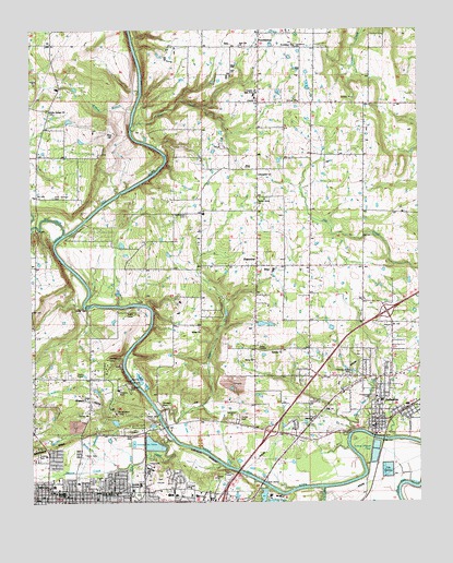
Judsonia, AR USGS Topographic Map
Click on map above to begin viewing in our Map Viewer.

This topographic map contains these locations and features:
Feature Name Type Latitude Longitude GNIS ID View Map
Adler CreekStreamN35.2740°W91.7090°45794View Map
Ahlf Junior High SchoolSchoolN35.2520°W91.7402°65030View Map
Ballew ChurchChurchN35.2831°W91.7318°46064View Map
Bee RockPopulated PlaceN35.2829°W91.7315°65037View Map
Bethel ChurchChurchN35.3304°W91.6765°46453View Map
Big CreekStreamN35.3220°W91.7404°81369View Map
Black CreekStreamN35.2537°W91.6568°46668View Map
Central Elementary SchoolSchoolN35.3579°W91.6779°65049View Map
Central High SchoolSchoolN35.3584°W91.6771°47658View Map
City of JudsoniaCivilN35.2770°W91.6410°2404813View Map
Clear Water (historical)Populated PlaceN35.3415°W91.6426°65051View Map
Clearwater ChurchChurchN35.3368°W91.6765°47843View Map
College Church of ChristChurchN35.2509°W91.7293°65052View Map
Corn Stalk BranchStreamN35.2676°W91.6479°76679View Map
Deener CreekStreamN35.2601°W91.7179°48438View Map
Doniphan LakeLakeN35.2510°W91.6760°74798View Map
Doniphan Lake DamDamN35.2509°W91.6757°79774View Map
Downtown Church of ChristChurchN35.2554°W91.7357°65060View Map
Evergreen CemeteryCemeteryN35.2779°W91.6401°48946View Map
Fairview Volunteer Fire StationBuildingN35.2825°W91.7493°2116423View Map
Foothills Technical InstituteSchoolN35.2551°W91.7154°65070View Map
Friendly Acres ParkParkN35.2840°W91.6426°49247View Map
Gin CreekStreamN35.2665°W91.7043°49424View Map
Grace United Methodist ChurchChurchN35.2534°W91.7249°65073View Map
Holly SpringsPopulated PlaceN35.3537°W91.7440°65082View Map
Holly Springs CemeteryCemeteryN35.3309°W91.7426°50246View Map
Holly Springs ChurchChurchN35.3537°W91.7435°50251View Map
JudsoniaPopulated PlaceN35.2701°W91.6399°77392View Map
Judsonia BridgeBridgeN35.2673°W91.6399°65085View Map
Judsonia Elementary SchoolSchoolN35.2769°W91.6389°65086View Map
Judsonia High SchoolSchoolN35.2768°W91.6374°65087View Map
Judsonia Middle SchoolSchoolN35.2766°W91.6390°2039125View Map
Judsonia Police DepartmentBuildingN35.2708°W91.6395°2118621View Map
Judsonia Volunteer Fire DepartmentBuildingN35.2733°W91.6308°2116659View Map
Kiwanis ParkParkN35.2815°W91.7190°50891View Map
KKSY-FM (Bald Knob)TowerN35.2915°W91.6735°85157View Map
KMOA-AM (Kensett)TowerN35.2595°W91.6754°85095View Map
Knox CemeteryCemeteryN35.2626°W91.7326°50906View Map
KWCK-AM (Searcy)TowerN35.2506°W91.6874°85139View Map
KWCK-FM (Searcy)TowerN35.2506°W91.6874°85244View Map
Lion StadiumParkN35.2562°W91.7412°65095View Map
Lower DamDamN35.2734°W91.7090°75004View Map
McRae Elementary SchoolSchoolN35.2547°W91.7432°65097View Map
Oakdale Landmark Missionary Baptist ChurchChurchN35.2901°W91.6696°77885View Map
Oakdale Nursing HomeHospitalN35.2681°W91.6654°52947View Map
Oakgrove CemeteryCemeteryN35.2537°W91.7307°77886View Map
Oaklawn CemeteryCemeteryN35.2559°W91.7304°52968View Map
Owl CreekStreamN35.3484°W91.7174°53110View Map
Pine HillSummitN35.3476°W91.7229°58376View Map
PlainviewPopulated PlaceN35.3126°W91.6771°58397View Map
Pleasant Grove Baptist ChurchChurchN35.2534°W91.7396°65103View Map
ProvidencePopulated PlaceN35.3704°W91.6762°58440View Map
Providence ChurchChurchN35.3706°W91.6646°53829View Map
Riverview High SchoolSchoolN35.2554°W91.6888°2039127View Map
Riverview Junior High SchoolSchoolN35.2548°W91.6892°2121467View Map
Rocky BranchStreamN35.2593°W91.7226°54129View Map
Salem ChurchChurchN35.2956°W91.6954°54499View Map
SearcyPopulated PlaceN35.2506°W91.7362°78309View Map
Searcy Medical CenterHospitalN35.2520°W91.7037°65111View Map
Searcy Post OfficePost OfficeN35.2534°W91.7437°84292View Map
Searcy QuarryMineN35.2814°W91.6850°2564064View Map
Short (historical)Populated PlaceN35.3598°W91.7404°65113View Map
Township of HarrisonCivilN35.2952°W91.6467°69836View Map
Unity Health White County Medical CenterHospitalN35.2520°W91.6971°65126View Map
Upper DamDamN35.3020°W91.7324°75188View Map
Walton BranchStreamN35.3540°W91.7165°56027View Map
West Race Baptist ChurchChurchN35.2509°W91.7479°65124View Map
White CountyCivilN35.2563°W91.7456°69906View Map
White County Central Elementary SchoolSchoolN35.3577°W91.6781°2039123View Map
White County Central High SchoolSchoolN35.3587°W91.6770°2039124View Map
White County CourthouseBuildingN35.2504°W91.7382°65125View Map
White County Memorial Hospital HeliportAirportN35.2515°W91.6910°83828View Map
Wyldewood CampLocaleN35.2873°W91.7260°56572View Map
Wyldewood LakeReservoirN35.2784°W91.7335°79769View Map
Wyldewood Lake DamDamN35.2784°W91.7335°79768View Map

Note: Coordinates in the location and feature list above are referenced to NAD83 datum.


Copyright (C) 2008-2025 Ryan Niemi / Sunset Dynamics ... All Rights Reserved