TopoQuest Logo
Do you find TopoQuest useful?
Help keep TopoQuest running and adding new maps/features by donating!
Bitcoin:  19c7KJd3qBynnjoSw5npx9KScwjBe4ifkT
Litecoin:  LXs6TkuXGGXo1vDsWCkWVdjQX94eUKd6ui
Home View Maps Find Maps Find Places Resources & Links


Isle Au Haut East, Maine Topographic Map

USGS Map Title: Isle Au Haut East, ME
USGS Map MRC: 44068A5
DRG (GeoTIFF) Download: o44068a5.tif


Neighboring USGS Topographic Map Quads:


  Deer Isle, ME  
44068B6
 

  Stinson Neck, ME  
44068B5
 

  Swans Island, ME  
44068B4
 

  Isle Au Haut West, ME  
44068A6
 

  Isle Au Haut East, ME  
44068A5
 

  Johns Island, ME  
44068A4


Map MRC Location:

N45°
W69°
N45°
W68°
H8 H7 H6 H5 H4 H3 H2 H1
G8 G7 G6 G5 G4 G3 G2 G1
F8 F7 F6 F5 F4 F3 F2 F1
E8 E7 E6 E5 E4 E3 E2 E1
D8 D7 D6 D5 D4 D3 D2 D1
C8 C7 C6 C5 C4 C3 C2 C1
B8 B7 B6 B5 B4 B3 B2 B1
A8 A7 A6 A5 A4 A3 A2 A1
N44°
W69°
N44°
W68°

Isle Au Haut East, ME USGS 1:24K Topographic Map Preview:
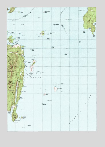
Isle Au Haut East, ME USGS Topographic Map
Click on map above to begin viewing in our Map Viewer.

This topographic map contains these locations and features:
Feature Name Type Latitude Longitude GNIS ID View Map
Airy LedgeBarN44.0848°W68.5892°581671View Map
Barter CreekStreamN44.0876°W68.6175°580068View Map
Battery IslandIslandN44.0517°W68.6003°579946View Map
Blackhorse IslandIslandN44.0270°W68.5756°579949View Map
Blue Hill RockBarN44.0940°W68.5397°580062View Map
Boom BeachBeachN44.0331°W68.6078°580144View Map
Boxam CoveBayN44.1015°W68.5103°562815View Map
Boxam LedgeBarN44.0995°W68.5145°580057View Map
Bull BrookStreamN44.0390°W68.6139°580046View Map
Bull BrookStreamN44.0267°W68.6128°563151View Map
Burnt IslandIslandN44.0923°W68.6189°579088View Map
Burnt Island ThorofareChannelN44.0890°W68.6136°579089View Map
Burnt LedgeIslandN44.0973°W68.6064°578935View Map
Burnt LedgeBarN44.0981°W68.6072°580061View Map
Cape Ann LedgeBarN44.0106°W68.6172°580148View Map
Channel RockIslandN44.1084°W68.6028°578932View Map
Colby LedgeBarN44.1237°W68.5928°581704View Map
Colby PupBarN44.1154°W68.5922°581705View Map
Colt LedgeBarN44.0204°W68.5667°581708View Map
Coombs MountainSummitN44.0808°W68.6117°564334View Map
Dodges CoveBayN44.0662°W68.6006°580072View Map
Doliver IslandIslandN44.0717°W68.5897°565183View Map
Drunkard LedgeBarN44.0773°W68.5450°580059View Map
Duck BrookStreamN44.0706°W68.6017°580073View Map
Eastern Ear IslandIslandN44.0134°W68.6056°579964View Map
Eastern Ear LedgeBarN44.0059°W68.6139°580146View Map
Eastern HeadSummitN44.0145°W68.6156°565719View Map
Edies TrailTrailN44.0642°W68.6222°580074View Map
Fog IslandIslandN44.0984°W68.5753°566340View Map
Gooseberry IslandIslandN44.1198°W68.6075°566951View Map
Great MeadowSwampN44.0492°W68.6167°580069View Map
Great Spoon IslandIslandN44.0434°W68.5567°567180View Map
Great Spoon LedgeBarN44.0484°W68.5506°580070View Map
Green LedgeIslandN44.0926°W68.5647°567244View Map
Halfway RockBarN44.0490°W68.5850°581766View Map
Head HarborBayN44.0148°W68.6214°579092View Map
Horseman LedgeBarN44.0426°W68.5939°581781View Map
Horseman PointCapeN44.0454°W68.6017°568297View Map
Horseman Point TrailTrailN44.0479°W68.6061°580071View Map
Isle Au HautIslandN44.0726°W68.6125°581583View Map
Jerusalem MountainSummitN44.0500°W68.6229°568814View Map
Jerusalem Mountain TrailTrailN44.0690°W68.6247°580886View Map
Jobs LedgeBarN44.0851°W68.5039°580058View Map
Little Spoon IslandIslandN44.0379°W68.5717°570071View Map
Long PondLakeN44.0384°W68.6119°570274View Map
Lower HeadCapeN44.0973°W68.5045°570504View Map
Marshall IslandIslandN44.1129°W68.5075°570822View Map
McGlathery IslandIslandN44.1215°W68.6167°570983View Map
Mouse IslandIslandN44.0948°W68.6231°571825View Map
Negro HeadCliffN44.0867°W68.5961°580066View Map
North Popplestone LedgeBarN44.1073°W68.5603°572397View Map
Old CoveBayN44.0831°W68.6022°572691View Map
Old Cove TrailTrailN44.0851°W68.6061°580067View Map
Pats BrookStreamN44.0515°W68.6028°573055View Map
Pell Island PassageChannelN44.0967°W68.6236°1909568View Map
Pond PointBayN44.0931°W68.6106°573608View Map
Popplestone PointCapeN44.0592°W68.5917°573654View Map
Rabbits EarIslandN44.0687°W68.5911°573953View Map
Rabbits EarIslandN44.0692°W68.5922°580065View Map
Richs CoveBayN44.0759°W68.6020°574179View Map
Richs LedgeBarN44.0820°W68.5925°580063View Map
Richs PointCapeN44.0856°W68.6017°574181View Map
Rocky MountainSummitN44.0637°W68.6192°574397View Map
SaddlebackBarN44.1120°W68.5381°574658View Map
Sawyer MountainSummitN44.0605°W68.6203°574970View Map
Seal LedgesBarN44.0404°W68.6025°580143View Map
Sheep Thief GulchBayN44.0265°W68.6122°580145View Map
South Popplestone LedgeBarN44.0984°W68.5664°575892View Map
Southern Mark IslandIslandN44.1198°W68.5722°575937View Map
Spirit LedgeBarN44.0884°W68.5231°576057View Map
Sprague LedgeBarN44.0929°W68.5081°581919View Map
The Cow PenIslandN44.0584°W68.5775°580004View Map
Three Bush IslandIslandN44.1212°W68.5192°577052View Map
Thunder GulchBayN44.0112°W68.6150°580147View Map
Thunder Gulch TrailTrailN44.0159°W68.6170°580149View Map
Torrey LedgeBarN44.0684°W68.5645°581940View Map
Town of Isle au HautCivilN44.0401°W68.6144°582530View Map
Turnip YardBarN44.0548°W68.5928°581949View Map
Turnip YardBayN44.0570°W68.5964°577445View Map
Unorganized Territory of Marshall IslandCivilN44.1056°W68.5111°2378263View Map
Wheat IslandIslandN44.0981°W68.6164°578306View Map
White LedgeIslandN44.0840°W68.5614°578363View Map
Whitehorse IslandIslandN44.0312°W68.5686°580015View Map
York IslandIslandN44.0656°W68.5892°578780View Map
York LedgesBarN44.0751°W68.5881°580064View Map

Note: Coordinates in the location and feature list above are referenced to NAD83 datum.


Copyright (C) 2008-2024 Ryan Niemi / Sunset Dynamics ... All Rights Reserved