TopoQuest Logo
Do you find TopoQuest useful?
Help keep TopoQuest running and adding new maps/features by donating!
Bitcoin:  19c7KJd3qBynnjoSw5npx9KScwjBe4ifkT
Litecoin:  LXs6TkuXGGXo1vDsWCkWVdjQX94eUKd6ui
Home View Maps Find Maps Find Places Resources & Links


Deer Isle, Maine Topographic Map

USGS Map Title: Deer Isle, ME
USGS Map MRC: 44068B6
DRG (GeoTIFF) Download: o44068b6.tif


Neighboring USGS Topographic Map Quads:


  Cape Rosier, ME  
44068C7
 

  Sargentville, ME  
44068C6
 

  Brooklin, ME  
44068C5
 

  North Haven East, ME  
44068B7
 

  Deer Isle, ME  
44068B6
 

  Stinson Neck, ME  
44068B5
 

  Vinalhaven, ME  
44068A7
 

  Isle Au Haut West, ME  
44068A6
 

  Isle Au Haut East, ME  
44068A5


Map MRC Location:

N45°
W69°
N45°
W68°
H8 H7 H6 H5 H4 H3 H2 H1
G8 G7 G6 G5 G4 G3 G2 G1
F8 F7 F6 F5 F4 F3 F2 F1
E8 E7 E6 E5 E4 E3 E2 E1
D8 D7 D6 D5 D4 D3 D2 D1
C8 C7 C6 C5 C4 C3 C2 C1
B8 B7 B6 B5 B4 B3 B2 B1
A8 A7 A6 A5 A4 A3 A2 A1
N44°
W69°
N44°
W68°

Deer Isle, ME USGS 1:24K Topographic Map Preview:
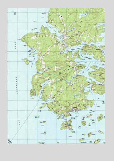
Deer Isle, ME USGS Topographic Map
Click on map above to begin viewing in our Map Viewer.

This topographic map contains these locations and features:
Feature Name Type Latitude Longitude GNIS ID View Map
Advent Christian Fellowship ChurchChurchN44.2237°W68.6784°1911331View Map
Allen CoveBayN44.1501°W68.6784°580365View Map
Ames CemeteryCemeteryN44.1587°W68.6475°2730105View Map
Ames PondLakeN44.1596°W68.6483°561236View Map
Andrew IslandIslandN44.1448°W68.7028°579944View Map
Bare IslandIslandN44.1359°W68.6309°561595View Map
Barred IslandIslandN44.1665°W68.7195°561631View Map
Barred Island LedgeBarN44.1640°W68.7192°580359View Map
Barred Island PreserveParkN44.1670°W68.7195°1911380View Map
Bay LedgeBarN44.1417°W68.6981°580368View Map
Brays MountainSummitN44.2134°W68.6484°580377View Map
Brays NarrowsChannelN44.2056°W68.6520°580373View Map
Buckmaster NeckCapeN44.1742°W68.6328°563122View Map
Burnt CoveBayN44.1631°W68.6995°563226View Map
Burnt HillSummitN44.1556°W68.6853°580362View Map
Burntland PondLakeN44.1694°W68.6618°563273View Map
Camp IslandIslandN44.1479°W68.6300°563401View Map
Cat CoveBayN44.1945°W68.6328°563682View Map
Channel Rock IslandIslandN44.1662°W68.6342°579956View Map
Chase Emerson Memorial LibraryBuildingN44.2240°W68.6799°1911477View Map
Crockett CoveBayN44.1734°W68.7061°564536View Map
Crockett Cove WoodsWoodsN44.1681°W68.7009°1911506View Map
Crockett Cove Woods PreserveParkN44.1773°W68.6966°1911507View Map
Crotch IslandIslandN44.1415°W68.6784°564581View Map
Crow IslandIslandN44.2465°W68.7411°564606View Map
Current IslandIslandN44.2042°W68.6495°580375View Map
Deep HoleBayN44.2140°W68.6578°564965View Map
Deer Island Thorofare Light StationBuildingN44.1342°W68.7034°1911518View Map
Deer IsleIslandN44.2101°W68.6853°564990View Map
Deer IslePopulated PlaceN44.2240°W68.6775°564991View Map
Deer Isle Post OfficePost OfficeN44.2239°W68.6793°1911521View Map
Deer Isle Stonington Elementary SchoolSchoolN44.2438°W68.6754°1911519View Map
Deer Isle Stonington High SchoolSchoolN44.2420°W68.6804°1911520View Map
Deer Isle Volunteer Fire DepartmentBuildingN44.2200°W68.6749°2552845View Map
Dow LedgeBarN44.1556°W68.6464°580772View Map
Dow PointCapeN44.2379°W68.6970°580343View Map
Dunham PointCapeN44.2215°W68.7309°565407View Map
Dunham Point LedgeBarN44.2231°W68.7342°580346View Map
East Penobscot BayBayN44.1459°W68.7459°565655View Map
Fifield PointCapeN44.1579°W68.7064°566134View Map
Flat IslandIslandN44.2301°W68.7161°580345View Map
Flea IslandIslandN44.1473°W68.6506°566294View Map
Forest CemeteryCemeteryN44.1601°W68.6817°566381View Map
Galilean Gospel TempleChurchN44.1604°W68.6589°1911626View Map
George Head IslandIslandN44.1279°W68.6545°566739View Map
Georges PondLakeN44.1839°W68.6845°566748View Map
Goose CoveBayN44.1681°W68.7153°566908View Map
Green HeadCapeN44.1512°W68.6703°567206View Map
Green IslandIslandN44.1440°W68.6514°567216View Map
Greenlaw CoveBayN44.2170°W68.6353°579972View Map
Greenwood CemeteryCemeteryN44.1903°W68.6281°567310View Map
Grog LedgeBarN44.1634°W68.6284°567347View Map
Gull LedgeBarN44.2373°W68.7136°567383View Map
Heart IslandIslandN44.2451°W68.7020°567868View Map
Hillside CemeteryCemeteryN44.2067°W68.6986°2736654View Map
Hitz PointCapeN44.2112°W68.7178°580348View Map
Holt PondLakeN44.1843°W68.6681°568221View Map
Huckleberry IslandIslandN44.2104°W68.6659°580380View Map
Humpkins IslandIslandN44.1587°W68.6345°580781View Map
Inner HarborHarborN44.1909°W68.6506°568647View Map
John IslandIslandN44.1312°W68.6709°568888View Map
John L Goss Quarry (historical)MineN44.1392°W68.6711°1911708View Map
Kiahs IslandIslandN44.1765°W68.6464°580372View Map
Knowlton CemeteryCemeteryN44.1655°W68.6553°2736667View Map
Labrador SwampSwampN44.1906°W68.6839°580354View Map
Lily PondReservoirN44.2299°W68.6678°569570View Map
Lily Pond DamDamN44.2274°W68.6733°1774567View Map
Little Camp IslandIslandN44.1462°W68.6378°569724View Map
Little Crow IslandIslandN44.2312°W68.7109°580344View Map
Little George Head IslandIslandN44.1256°W68.6486°569793View Map
Long CoveBayN44.2101°W68.6725°570192View Map
Mark IslandIslandN44.1337°W68.7022°570779View Map
Memorial Ambulance CorpsBuildingN44.2183°W68.6676°2666817View Map
Mill CoveBayN44.1426°W68.6675°571320View Map
Mill IslandIslandN44.2070°W68.7192°580350View Map
Mill PondLakeN44.2204°W68.6808°580308View Map
Mill PondBayN44.2092°W68.7153°571334View Map
Moose IslandIslandN44.1484°W68.6828°571597View Map
Mount Adams CemeteryCemeteryN44.2231°W68.6692°580307View Map
Mount Warren CemeteryCemeteryN44.1954°W68.6622°2736677View Map
MountainvillePopulated PlaceN44.2120°W68.6289°571820View Map
Northwest HarborHarborN44.2298°W68.6914°572475View Map
Old Settlers CemeteryCemeteryN44.2161°W68.6761°2736690View Map
Olivers PondLakeN44.1968°W68.6922°572743View Map
Peggys IslandIslandN44.1481°W68.6692°577080View Map
Pigeon IslandIslandN44.2095°W68.7209°580349View Map
Polypod IslandIslandN44.2031°W68.6422°580374View Map
Potato IslandIslandN44.1329°W68.6509°573714View Map
Potato IslandIslandN44.1440°W68.6420°573715View Map
Pressey CoveBayN44.2290°W68.7120°573793View Map
Rabbit IslandIslandN44.1740°W68.7059°580357View Map
Rock IslandIslandN44.1401°W68.6589°574341View Map
Roebuck LedgeBarN44.1520°W68.6447°580370View Map
Russ IslandIslandN44.1506°W68.6434°574601View Map
Saint Helena IslandIslandN44.1329°W68.6447°574716View Map
Salmon PointCapeN44.2154°W68.7245°580347View Map
Salome Sellers House MuseumBuildingN44.2009°W68.7053°1911900View Map
Sam Stick LedgeBarN44.1454°W68.6603°580369View Map
Sams IslandIslandN44.1781°W68.7050°580356View Map
Sand IslandIslandN44.1359°W68.6667°574843View Map
Sawyers IslandIslandN44.2120°W68.6553°580376View Map
Scott IslandIslandN44.1490°W68.6542°575050View Map
Scraggy IslandIslandN44.1251°W68.7075°579094View Map
Second IslandIslandN44.1498°W68.7106°580363View Map
Setters RockBarN44.1704°W68.7323°580358View Map
Settlement QuarryMineN44.1754°W68.6397°1911934View Map
Sheephead IslandIslandN44.2012°W68.7253°575359View Map
Sheephead Island LedgeBarN44.1929°W68.7225°580353View Map
Smalls CoveBayN44.1723°W68.7172°575567View Map
South Deer IslePopulated PlaceN44.1940°W68.6625°580003View Map
Southeast HarborHarborN44.2006°W68.6411°575931View Map
Southwest HarborBayN44.2009°W68.7153°580352View Map
Sprout IslandIslandN44.1426°W68.6434°578900View Map
Staple PointCapeN44.1545°W68.6603°580371View Map
Steve IslandIslandN44.1262°W68.6456°576315View Map
Stinson PointSummitN44.1721°W68.7178°576361View Map
StoningtonPopulated PlaceN44.1562°W68.6667°576391View Map
Stonington Elementary SchoolSchoolN44.1584°W68.6672°1911980View Map
Stonington Methodist ChurchChurchN44.1565°W68.6625°1911981View Map
Stonington Municipal AirportAirportN44.1734°W68.6810°581992View Map
Stonington Post OfficePost OfficeN44.1550°W68.6669°1911982View Map
Stonington Public LibraryBuildingN44.1563°W68.6633°2738515View Map
Stonington Volunteer Fire DepartmentBuildingN44.1558°W68.6626°2553196View Map
SunsetPopulated PlaceN44.2059°W68.7047°576548View Map
Sunset Post OfficePost OfficeN44.2066°W68.7038°1911991View Map
Sylvester CoveBayN44.2120°W68.7192°576625View Map
Teakettle IslandIslandN44.2126°W68.6600°580379View Map
The FortIslandN44.1551°W68.7097°576803View Map
The HauloverGapN44.2162°W68.6742°576813View Map
Thurlow HeadCapeN44.1390°W68.6692°577078View Map
Toffet PondLakeN44.1899°W68.6842°580355View Map
Toothacher LedgeBarN44.1973°W68.6250°577194View Map
Torrey PondLakeN44.2439°W68.6493°580007View Map
Town of Deer IsleCivilN44.2312°W68.7224°582437View Map
Town of StoningtonCivilN44.1511°W68.6445°582751View Map
Trundys PointCapeN44.2070°W68.7161°580351View Map
Twin LedgesBarN44.1334°W68.6864°580366View Map
Two Bush IslandIslandN44.1484°W68.6653°577501View Map
Warren PointCapeN44.1956°W68.6545°577851View Map
Webb CoveBayN44.1698°W68.6422°577921View Map
West Deer IslePopulated PlaceN44.1684°W68.6950°580360View Map
West Mark Island LedgeBarN44.1501°W68.7303°580361View Map
West StoningtonPopulated PlaceN44.1665°W68.6914°578229View Map
Western Deer Island LedgeBarN44.1445°W68.6995°580364View Map
Whig IslandIslandN44.2165°W68.6522°580378View Map
Whitmore NeckIslandN44.1881°W68.6303°578407View Map
Wreck IslandIslandN44.1265°W68.6361°578714View Map
Yellow RockBarN44.1448°W68.6845°580367View Map

Note: Coordinates in the location and feature list above are referenced to NAD83 datum.


Copyright (C) 2008-2025 Ryan Niemi / Sunset Dynamics ... All Rights Reserved