TopoQuest Logo
Do you find TopoQuest useful?
Help keep TopoQuest running and adding new maps/features by donating!
Bitcoin:  19c7KJd3qBynnjoSw5npx9KScwjBe4ifkT
Litecoin:  LXs6TkuXGGXo1vDsWCkWVdjQX94eUKd6ui
Home View Maps Find Maps Find Places Resources & Links


Isle Au Haut West, Maine Topographic Map

USGS Map Title: Isle Au Haut West, ME
USGS Map MRC: 44068A6
DRG (GeoTIFF) Download: o44068a6.tif


Neighboring USGS Topographic Map Quads:


  North Haven East, ME  
44068B7
 

  Deer Isle, ME  
44068B6
 

  Stinson Neck, ME  
44068B5
 

  Vinalhaven, ME  
44068A7
 

  Isle Au Haut West, ME  
44068A6
 

  Isle Au Haut East, ME  
44068A5


Map MRC Location:

N45°
W69°
N45°
W68°
H8 H7 H6 H5 H4 H3 H2 H1
G8 G7 G6 G5 G4 G3 G2 G1
F8 F7 F6 F5 F4 F3 F2 F1
E8 E7 E6 E5 E4 E3 E2 E1
D8 D7 D6 D5 D4 D3 D2 D1
C8 C7 C6 C5 C4 C3 C2 C1
B8 B7 B6 B5 B4 B3 B2 B1
A8 A7 A6 A5 A4 A3 A2 A1
N44°
W69°
N44°
W68°

Isle Au Haut West, ME USGS 1:24K Topographic Map Preview:
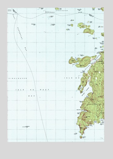
Isle Au Haut West, ME USGS Topographic Map
Click on map above to begin viewing in our Map Viewer.

This topographic map contains these locations and features:
Feature Name Type Latitude Longitude GNIS ID View Map
Bald MountainSummitN44.0558°W68.6500°561513View Map
Barred HarborBayN44.0187°W68.6367°580700View Map
Barter Island LedgesBarN44.1179°W68.6345°580153View Map
Bay WestBarN44.0865°W68.6536°580155View Map
Big BrewsterIslandN44.0092°W68.6603°580088View Map
Bills IslandIslandN44.1070°W68.6281°581393View Map
Birch PointCapeN44.0879°W68.6261°562329View Map
Black DinaSummitN44.0641°W68.6342°562432View Map
Black Dina TrailTrailN44.0637°W68.6372°580163View Map
Black LedgesBarN44.0073°W68.6581°580087View Map
Bowditch TrailTrailN44.0529°W68.6295°580885View Map
Channel RockBarN44.1034°W68.6839°563840View Map
Cliff TrailTrailN44.0101°W68.6520°580089View Map
Deep CoveBayN44.0426°W68.6472°580161View Map
Duck HarborBayN44.0287°W68.6528°565336View Map
Duck Harbor CampgroundLocaleN44.0306°W68.6509°1909451View Map
Duck Harbor CemeteryCemeteryN44.0277°W68.6431°2736791View Map
Duck Harbor LandingLocaleN44.0287°W68.6509°1909452View Map
Duck Harbor LedgeBarN44.0365°W68.6625°580166View Map
Duck Harbor MountainSummitN44.0231°W68.6491°565338View Map
Duck Harbor TrailTrailN44.0440°W68.6409°580160View Map
Ebens HeadCapeN44.0301°W68.6550°580170View Map
Ebens Head TrailTrailN44.0334°W68.6547°580169View Map
Ewe IslandIslandN44.1129°W68.6647°565977View Map
Farrel IslandIslandN44.1237°W68.6850°566069View Map
Flake IslandIslandN44.0856°W68.6359°580775View Map
Flat LedgeBarN44.0087°W68.6467°581738View Map
George Head LedgeBarN44.1234°W68.6545°566740View Map
Goss BeachBeachN44.0476°W68.6397°1909472View Map
Haddock LedgeBarN44.0267°W68.6606°580168View Map
Harbor IslandIslandN44.1112°W68.6445°567588View Map
Harbor Island LedgeBarN44.1148°W68.6484°581768View Map
Hardwood IslandIslandN44.1087°W68.6659°567618View Map
Isle Au HautPopulated PlaceN44.0754°W68.6334°568702View Map
Isle Au Haut BayBayN44.0470°W68.7167°568703View Map
Isle Au Haut Light StationLocaleN44.0648°W68.6514°1909495View Map
Isle Au Haut Rural SchoolSchoolN44.0768°W68.6314°1909496View Map
Isle Au Haut ThorofareChannelN44.0731°W68.6409°568705View Map
Keeler RockBarN44.0101°W68.6631°581792View Map
Kimball HeadSummitN44.0759°W68.6675°569175View Map
Kimball IslandIslandN44.0762°W68.6475°569179View Map
Kimball RockBarN44.0706°W68.6842°581795View Map
Laundry CoveBayN44.0856°W68.6270°580156View Map
Leach RockBarN44.1084°W68.6259°580154View Map
LookoutLocaleN44.0829°W68.6284°570349View Map
Lookout PointCapeN44.0812°W68.6306°580157View Map
Marsh CoveBayN44.0726°W68.6634°570802View Map
Marsh Cove HeadCapeN44.0704°W68.6556°570804View Map
Marsh Cove LedgesBarN44.0698°W68.6689°581818View Map
Merchant BrookStreamN44.0234°W68.6286°571138View Map
Merchant IslandIslandN44.1029°W68.6453°571139View Map
Merchant Island CemeteryCemeteryN44.1019°W68.6415°2736796View Map
Merchant RowChannelN44.1181°W68.6436°579988View Map
Merchants CoveBayN44.0206°W68.6281°580709View Map
Merchants PointCapeN44.0179°W68.6297°580710View Map
Middle LedgesBarN44.0084°W68.6570°580090View Map
Moores HarborBayN44.0434°W68.6525°581462View Map
Moores Harbor LedgeBarN44.0384°W68.6606°581830View Map
Moores HeadCapeN44.0459°W68.6550°571560View Map
Moxie IslandIslandN44.0765°W68.6386°578892View Map
Nathan IslandIslandN44.0962°W68.6350°572072View Map
National Merchant TrailTrailN44.0331°W68.6250°580162View Map
Northwest CoveBayN44.0776°W68.6620°580159View Map
Outer Scrag LedgeBarN44.1087°W68.7131°572868View Map
Pell IslandIslandN44.0998°W68.6259°573132View Map
Ram IslandIslandN44.1045°W68.6720°573995View Map
Ram Island LedgeBarN44.1017°W68.6800°581876View Map
Revere Memorial LibraryBuildingN44.0766°W68.6328°1909581View Map
Robinson PointCapeN44.0634°W68.6511°574329View Map
Rock TBarN44.0379°W68.6700°581928View Map
Rosebud IslandIslandN44.0804°W68.6517°574459View Map
Round IslandIslandN44.1231°W68.6267°579093View Map
Saddleback LedgeBarN44.0142°W68.7273°574665View Map
Saddleback Ledge Light StationLocaleN44.0145°W68.7434°1909614View Map
Saddleback Ledge ShoalBarN44.0415°W68.7389°581886View Map
Sawyer LedgeBarN44.0673°W68.6545°581889View Map
Sawyer Notch TrailTrailN44.0737°W68.6272°1909626View Map
Scraggy LedgeIslandN44.1042°W68.6922°581890View Map
Seal Point TrailTrailN44.0523°W68.6497°580164View Map
Sharks PointCapeN44.0373°W68.6531°580171View Map
Sparrow IslandIslandN44.1165°W68.6947°575973View Map
Sparrow Island LedgesBarN44.1162°W68.7042°580151View Map
Squeaker CoveBayN44.0159°W68.6439°580701View Map
The BandiesIslandN44.0223°W68.6928°580167View Map
The Brown CowIslandN44.1240°W68.7361°580150View Map
The Seal TrapBayN44.0490°W68.6559°576921View Map
The WashersBarN44.0092°W68.6709°581952View Map
Trail Point TrailTrailN44.0512°W68.6559°580165View Map
Trial PointCapeN44.0504°W68.6589°577308View Map
Trial Point LedgeBarN44.0451°W68.6645°581941View Map
Turners CemeteryCemeteryN44.0765°W68.6345°580158View Map
Wentworth MountainSummitN44.0396°W68.6377°578006View Map
West Halibut LedgesBarN44.1090°W68.6936°578153View Map
West Malibu LedgesBarN44.1087°W68.6936°580152View Map
Western Ear IslandIslandN44.0040°W68.6547°580797View Map
Western HeadSummitN44.0131°W68.6523°578254View Map
Western Head TrailTrailN44.0126°W68.6561°580086View Map

Note: Coordinates in the location and feature list above are referenced to NAD83 datum.


Copyright (C) 2008-2024 Ryan Niemi / Sunset Dynamics ... All Rights Reserved