TopoQuest Logo
Do you find TopoQuest useful?
Help keep TopoQuest running and adding new maps/features by donating!
Bitcoin:  19c7KJd3qBynnjoSw5npx9KScwjBe4ifkT
Litecoin:  LXs6TkuXGGXo1vDsWCkWVdjQX94eUKd6ui
Home View Maps Find Maps Find Places Resources & Links


Tignall, Georgia Topographic Map

USGS Map Title: Tignall, GA
USGS Map MRC: 33082G6
DRG (GeoTIFF) Download: o33082g6.tif


Neighboring USGS Topographic Map Quads:


  Jacksons Crossroads, GA  
33082H7
 

  Broad, GA  
33082H6
 

  Chennault, GA  
33082H5
 

  Celeste, GA  
33082G7
 

  Tignall, GA  
33082G6
 

  Metasville, GA  
33082G5
 

  Washington West, GA  
33082F7
 

  Washington East, GA  
33082F6
 

  Aonia, GA  
33082F5


Map MRC Location:

N34°
W83°
N34°
W82°
H8 H7 H6 H5 H4 H3 H2 H1
G8 G7 G6 G5 G4 G3 G2 G1
F8 F7 F6 F5 F4 F3 F2 F1
E8 E7 E6 E5 E4 E3 E2 E1
D8 D7 D6 D5 D4 D3 D2 D1
C8 C7 C6 C5 C4 C3 C2 C1
B8 B7 B6 B5 B4 B3 B2 B1
A8 A7 A6 A5 A4 A3 A2 A1
N33°
W83°
N33°
W82°

Tignall, GA USGS 1:24K Topographic Map Preview:
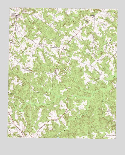
Tignall, GA USGS Topographic Map
Click on map above to begin viewing in our Map Viewer.

This topographic map contains these locations and features:
Feature Name Type Latitude Longitude GNIS ID View Map
Anderson Mill CreekStreamN33.7943°W82.6510°310528View Map
Armstrong BranchStreamN33.7837°W82.7260°310620View Map
Benson BranchStreamN33.7976°W82.6387°311091View Map
Cherry Grove ChurchChurchN33.7682°W82.6979°342743View Map
Cherry Grove SchoolSchoolN33.7676°W82.6985°312617View Map
CohentownPopulated PlaceN33.7940°W82.7185°331427View Map
DanburgPopulated PlaceN33.8685°W82.6521°355435View Map
Danburg CemeteryCemeteryN33.8701°W82.6529°342747View Map
Danburg ChurchChurchN33.8698°W82.6526°342748View Map
Danburg SchoolSchoolN33.8629°W82.6596°313279View Map
Danburg Volunteer Fire DepartmentBuildingN33.8679°W82.6517°2604941View Map
Fishing Creek CemeteryCemeteryN33.8371°W82.6935°342760View Map
Fishing Creek ChurchChurchN33.8376°W82.6935°355806View Map
Floral HillPopulated PlaceN33.8340°W82.6251°355850View Map
Garrard DamDamN33.7585°W82.6965°338788View Map
Garrard LakeReservoirN33.7581°W82.6995°338789View Map
Hog ForkStreamN33.7893°W82.6893°315506View Map
Middle CreekStreamN33.7804°W82.7310°318069View Map
Mulberry ChurchChurchN33.8157°W82.6490°342780View Map
Mulberry SchoolSchoolN33.8162°W82.6493°319138View Map
Norman Lake DamDamN33.7518°W82.6915°336416View Map
Possie (historical)Populated PlaceN33.8115°W82.6437°342788View Map
Reeves ChapelChurchN33.8390°W82.7121°342791View Map
Reeves Chapel SchoolSchoolN33.8393°W82.7115°321482View Map
Rock CreekStreamN33.7785°W82.7393°321726View Map
Rosenwald High SchoolSchoolN33.8587°W82.7438°321934View Map
SandtownPopulated PlaceN33.8362°W82.6876°326503View Map
Sandy HillPopulated PlaceN33.8629°W82.6985°332973View Map
Threemile CreekStreamN33.7712°W82.7471°324144View Map
TignallPopulated PlaceN33.8676°W82.7413°356591View Map
Tignall CemeteryCemeteryN33.8668°W82.7387°342807View Map
Tignall Fire DepartmentBuildingN33.8673°W82.7411°2604947View Map
Tignall Police DepartmentBuildingN33.8669°W82.7412°2733569View Map
Town of TignallCivilN33.8674°W82.7420°2406734View Map
Wilkes CountyCivilN33.7819°W82.7432°351265View Map
Wynn CreekStreamN33.7896°W82.6571°325590View Map

Note: Coordinates in the location and feature list above are referenced to NAD83 datum.


Copyright (C) 2008-2025 Ryan Niemi / Sunset Dynamics ... All Rights Reserved