TopoQuest Logo
Do you find TopoQuest useful?
Help keep TopoQuest running and adding new maps/features by donating!
Bitcoin:  19c7KJd3qBynnjoSw5npx9KScwjBe4ifkT
Litecoin:  LXs6TkuXGGXo1vDsWCkWVdjQX94eUKd6ui
Home View Maps Find Maps Find Places Resources & Links


Jarosa, New Mexico Topographic Map

USGS Map Title: Jarosa, NM
USGS Map MRC: 36106A6
DRG (GeoTIFF) Download: o36106a6.tif


Neighboring USGS Topographic Map Quads:


  Gallina, NM  
36106B7
 

  Arroyo Del Agua, NM  
36106B6
 

  Youngsville, NM  
36106B5
 

  Nacimiento Peak, NM  
36106A7
 

  Jarosa, NM  
36106A6
 

  Cerro del Grant, NM  
36106A5
 

  Rancho del Chaparral, NM  
35106H7
 

  Seven Springs, NM  
35106H6
 

  Valle San Antonio, NM  
35106H5


Map MRC Location:

N37°
W107°
N37°
W106°
H8 H7 H6 H5 H4 H3 H2 H1
G8 G7 G6 G5 G4 G3 G2 G1
F8 F7 F6 F5 F4 F3 F2 F1
E8 E7 E6 E5 E4 E3 E2 E1
D8 D7 D6 D5 D4 D3 D2 D1
C8 C7 C6 C5 C4 C3 C2 C1
B8 B7 B6 B5 B4 B3 B2 B1
A8 A7 A6 A5 A4 A3 A2 A1
N36°
W107°
N36°
W106°

Jarosa, NM USGS 1:24K Topographic Map Preview:
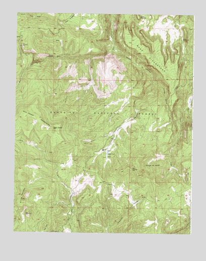
Jarosa, NM USGS Topographic Map
Click on map above to begin viewing in our Map Viewer.

This topographic map contains these locations and features:
Feature Name Type Latitude Longitude GNIS ID View Map
Aranda SpringSpringN36.0685°W106.6683°913818View Map
Aranda TankReservoirN36.0650°W106.6836°913817View Map
Bonita TankReservoirN36.0649°W106.6407°913812View Map
Bonito SpringSpringN36.1095°W106.7201°913783View Map
Branch TankReservoirN36.0455°W106.6846°904058View Map
Campground SpringSpringN36.1003°W106.7194°913825View Map
Caņada BonitaStreamN36.0872°W106.6531°904437View Map
Canada OjitosSpringN36.0922°W106.7159°913824View Map
Cerro JarocitoSummitN36.0592°W106.7225°904974View Map
Cerro SpringSpringN36.0552°W106.7273°913819View Map
Cochina SpringSpringN36.0311°W106.6304°913809View Map
Cochina SpringSpringN36.0408°W106.6417°913810View Map
Diego SpringSpringN36.0689°W106.7208°913821View Map
Dunlap SpringSpringN36.0276°W106.6814°913804View Map
Guardia CanyonValleyN36.0572°W106.6789°906773View Map
Guardia SpringSpringN36.0513°W106.6988°913814View Map
JarosaPopulated PlaceN36.0467°W106.6850°907323View Map
Jarosa CanyonValleyN36.1053°W106.6803°907324View Map
Jarosito SpringSpringN36.0582°W106.7059°913816View Map
Jarosito Trick TnakReservoirN36.0567°W106.7036°913815View Map
Jarossa MineMineN36.0264°W106.6986°917343View Map
Juan SpringSpringN36.0202°W106.6421°913808View Map
Lease PitMineN36.0809°W106.6720°917330View Map
Loma RedondaSummitN36.1225°W106.6636°908137View Map
Luterio SpringSpringN36.0370°W106.7360°913813View Map
Martinez TanksReservoirN36.0790°W106.6805°913822View Map
Mesa Ojitos Trick TankReservoirN36.1197°W106.6453°913786View Map
Mesa PinabetosaBenchN36.1011°W106.6561°908628View Map
Mining MountainSummitN36.0189°W106.7436°908796View Map
Nester SpringSpringN36.0515°W106.6362°913811View Map
Nick SpringSpringN36.0775°W106.7147°913823View Map
Pablo SpringSpringN36.0111°W106.6430°913807View Map
Pedro SpringSpringN36.0207°W106.6575°913805View Map
Pinabetosa Trick TankReservoirN36.1109°W106.6584°913785View Map
Rincon de JaquesBasinN36.0397°W106.6548°910179View Map
Rincon SpringSpringN36.1229°W106.7360°913784View Map
Rio Puerco CampgroundLocaleN36.1006°W106.7236°910254View Map
Rito CafeStreamN36.0220°W106.7064°910292View Map
Rito RedondoStreamN36.0984°W106.7481°910315View Map
Rito ResumideroStreamN36.0970°W106.7375°910316View Map
Saint JudeMineN36.0622°W106.6995°916725View Map
Teakettle RockArchN36.0475°W106.6889°911567View Map
Twin Ponds TankReservoirN36.0075°W106.6496°913806View Map
Vega CochinaValleyN36.0731°W106.6275°912082View Map

Note: Coordinates in the location and feature list above are referenced to NAD83 datum.


Copyright (C) 2008-2024 Ryan Niemi / Sunset Dynamics ... All Rights Reserved