TopoQuest Logo
Do you find TopoQuest useful?
Help keep TopoQuest running and adding new maps/features by donating!
Bitcoin:  19c7KJd3qBynnjoSw5npx9KScwjBe4ifkT
Litecoin:  LXs6TkuXGGXo1vDsWCkWVdjQX94eUKd6ui
Home View Maps Find Maps Find Places Resources & Links


Jasonville, Indiana Topographic Map

USGS Map Title: Jasonville, IN
USGS Map MRC: 39087B2
DRG (GeoTIFF) Download: o39087b2.tif


Neighboring USGS Topographic Map Quads:


  Lewis, IN  
39087C3
 

  Saline City, IN  
39087C2
 

  Clay City, IN  
39087C1
 

  Hymera, IN  
39087B3
 

  Jasonville, IN  
39087B2
 

  Coal City, IN  
39087B1
 

  Dugger, IN  
39087A3
 

  Linton, IN  
39087A2
 

  Switz City, IN  
39087A1


Map MRC Location:

N40°
W88°
N40°
W87°
H8 H7 H6 H5 H4 H3 H2 H1
G8 G7 G6 G5 G4 G3 G2 G1
F8 F7 F6 F5 F4 F3 F2 F1
E8 E7 E6 E5 E4 E3 E2 E1
D8 D7 D6 D5 D4 D3 D2 D1
C8 C7 C6 C5 C4 C3 C2 C1
B8 B7 B6 B5 B4 B3 B2 B1
A8 A7 A6 A5 A4 A3 A2 A1
N39°
W88°
N39°
W87°

Jasonville, IN USGS 1:24K Topographic Map Preview:
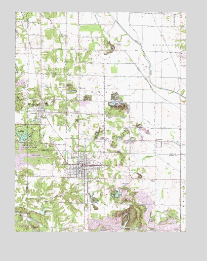
Jasonville, IN USGS Topographic Map
Click on map above to begin viewing in our Map Viewer.

This topographic map contains these locations and features:
Feature Name Type Latitude Longitude GNIS ID View Map
Bennington LakeReservoirN39.1512°W87.1672°430821View Map
Boat LakeLakeN39.1294°W87.1687°431269View Map
Bogle CornerPopulated PlaceN39.1775°W87.1847°431296View Map
Buchanan CornerPopulated PlaceN39.1925°W87.2033°431708View Map
Busseron Dam Number D-4DamN39.1367°W87.2097°447231View Map
Care Ambulance ServiceBuildingN39.1625°W87.1866°2719294View Map
City of JasonvilleCivilN39.1620°W87.1994°2395457View Map
CoalmontPopulated PlaceN39.1934°W87.2311°432712View Map
Coalmont Census Designated PlaceCensusN39.1932°W87.2265°2629878View Map
Coffee Post Office (historical)Post OfficeN39.2289°W87.1967°453001View Map
Eel River PrairieFlatN39.2048°W87.1622°447923View Map
Friendly Grove ChurchChurchN39.2359°W87.2136°434843View Map
GilmourPopulated PlaceN39.1314°W87.2408°435082View Map
Hickory LakeReservoirN39.2479°W87.2430°436109View Map
HowesvillePopulated PlaceN39.1770°W87.1470°436555View Map
Jason Lake DamDamN39.1684°W87.2383°448487View Map
JasonvillePopulated PlaceN39.1631°W87.1992°436943View Map
Jasonville Police DepartmentBuildingN39.1633°W87.2012°2758206View Map
Jasonville Volunteer Fire DepartmentBuildingN39.1625°W87.2003°2625678View Map
Lake KickapooReservoirN39.1674°W87.2454°2084319View Map
Lake LenapeReservoirN39.1681°W87.2328°452456View Map
Lake ShakamakReservoirN39.1793°W87.2441°443266View Map
Lateral Number FourCanalN39.1839°W87.1375°437639View Map
Latta YardLocaleN39.1500°W87.1961°452103View Map
Lebanon ChurchChurchN39.1259°W87.1845°437723View Map
Lewis Township Fire CompanyBuildingN39.1935°W87.2302°2626086View Map
Little Flock ChurchChurchN39.2145°W87.2206°438062View Map
Lone TreePopulated PlaceN39.1259°W87.1289°438240View Map
New Wilson ChurchChurchN39.1809°W87.1853°440126View Map
Oak Grove CemeteryCemeteryN39.1735°W87.1991°440406View Map
Old Union CemeteryCemeteryN39.1748°W87.2248°440613View Map
Possum HollowValleyN39.1405°W87.2485°441483View Map
Powell PondReservoirN39.1362°W87.2299°441521View Map
Redcuff CornerPopulated PlaceN39.1550°W87.1472°441826View Map
Sanders CemeteryCemeteryN39.2317°W87.1753°442995View Map
Shakamak AirportAirportN39.1667°W87.1907°449221View Map
Shakamak Elementary SchoolSchoolN39.1609°W87.1986°446972View Map
Shakamak High SchoolSchoolN39.1609°W87.1986°446973View Map
Shakamak Lake DamDamN39.1767°W87.2450°447854View Map
Shakamak Middle SchoolSchoolN39.1898°W87.2306°446971View Map
Shakamak State ParkParkN39.1692°W87.2427°2084318View Map
Township of LewisCivilN39.2233°W87.1885°453548View Map
Township of WrightCivilN39.1268°W87.1850°454065View Map

Note: Coordinates in the location and feature list above are referenced to NAD83 datum.


Copyright (C) 2008-2024 Ryan Niemi / Sunset Dynamics ... All Rights Reserved