TopoQuest Logo
Do you find TopoQuest useful?
Help keep TopoQuest running and adding new maps/features by donating!
Bitcoin:  19c7KJd3qBynnjoSw5npx9KScwjBe4ifkT
Litecoin:  LXs6TkuXGGXo1vDsWCkWVdjQX94eUKd6ui
Home View Maps Find Maps Find Places Resources & Links


Jasper, Indiana Topographic Map

USGS Map Title: Jasper, IN
USGS Map MRC: 38086D8
DRG (GeoTIFF) Download: o38086d8.tif


Neighboring USGS Topographic Map Quads:


  Glendale, IN  
38087E1
 

  Alfordsville, IN  
38086E8
 

  Rusk, IN  
38086E7
 

  Otwell, IN  
38087D1
 

  Jasper, IN  
38086D8
 

  Dubois, IN  
38086D7
 

  Velpen, IN  
38087C1
 

  Huntingburg, IN  
38086C8
 

  Saint Anthony, IN  
38086C7


Map MRC Location:

N39°
W87°
N39°
W86°
H8 H7 H6 H5 H4 H3 H2 H1
G8 G7 G6 G5 G4 G3 G2 G1
F8 F7 F6 F5 F4 F3 F2 F1
E8 E7 E6 E5 E4 E3 E2 E1
D8 D7 D6 D5 D4 D3 D2 D1
C8 C7 C6 C5 C4 C3 C2 C1
B8 B7 B6 B5 B4 B3 B2 B1
A8 A7 A6 A5 A4 A3 A2 A1
N38°
W87°
N38°
W86°

Jasper, IN USGS 1:24K Topographic Map Preview:
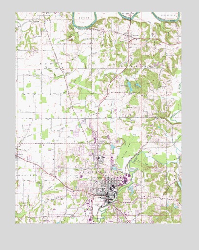
Jasper, IN USGS Topographic Map
Click on map above to begin viewing in our Map Viewer.

This topographic map contains these locations and features:
Feature Name Type Latitude Longitude GNIS ID View Map
Ackerman BranchStreamN38.4476°W86.9503°429996View Map
Alexander CemeteryCemeteryN38.3867°W86.9933°430061View Map
Alexander RunStreamN38.3831°W86.9897°430065View Map
Armory ParkParkN38.3992°W86.9394°430256View Map
Bison BranchStreamN38.4367°W86.9289°431111View Map
Briedenbaugh LakeReservoirN38.3851°W86.8796°448860View Map
Briedenbaugh Lake DamDamN38.3851°W86.8800°448859View Map
Buchta Airport (historical)AirportN38.4912°W86.9334°2677081View Map
Buck ShoalsBarN38.4951°W86.8778°431739View Map
Buffalo FlatFlatN38.4184°W86.9144°431775View Map
Buffalo StreamStreamN38.4064°W86.9200°431776View Map
Calf BranchStreamN38.4376°W86.9219°431957View Map
Calumet LakeReservoirN38.4076°W86.9251°448648View Map
Calumet Lake DamDamN38.4069°W86.9238°448647View Map
Calumet RunStreamN38.4028°W86.9122°431972View Map
Cavender CemeteryCemeteryN38.4523°W86.9153°432251View Map
Cavender RunStreamN38.4617°W86.9175°432252View Map
Chattin CemeteryCemeteryN38.4825°W86.9294°432437View Map
City of JasperCivilN38.3936°W86.9404°2395458View Map
Cline BrookStreamN38.4067°W86.9081°432665View Map
Coon RunStreamN38.4198°W86.8786°432936View Map
Cooper CemeteryCemeteryN38.4803°W86.9358°432941View Map
Cooper RunStreamN38.4778°W86.9289°432949View Map
Deerwood LakeReservoirN38.4569°W86.9077°433437View Map
Deerwood Lake DamDamN38.4578°W86.9089°448861View Map
Dillin CemeteryCemeteryN38.3795°W86.9808°433552View Map
Ditch BranchStreamN38.3776°W86.9361°433570View Map
Dubois County Sheriff's OfficeBuildingN38.3847°W86.9280°2758116View Map
East Fork Mill CreekStreamN38.4553°W86.9497°433895View Map
Evans BrookStreamN38.3881°W86.9789°434249View Map
Evans CemeteryCemeteryN38.3895°W86.9658°434250View Map
Fish RunStreamN38.3948°W86.9753°434515View Map
Grist RunStreamN38.4281°W86.9653°435514View Map
Gwin CemeteryCemeteryN38.4920°W86.8922°435567View Map
HaysvillePopulated PlaceN38.4856°W86.9150°435928View Map
Haysville Elementary SchoolSchoolN38.4848°W86.9125°446618View Map
Haysville RunStreamN38.4820°W86.9250°435930View Map
Haysville Volunteer Fire DepartmentBuildingN38.4846°W86.9096°2626472View Map
High DitchCanalN38.4598°W86.9103°436140View Map
Hole RunStreamN38.4614°W86.9686°436313View Map
Hope CemeteryCemeteryN38.4806°W86.8847°436434View Map
Hope DrainStreamN38.4948°W86.8897°436442View Map
Indiana State Police District 34BuildingN38.4083°W86.9387°2758150View Map
IrelandPopulated PlaceN38.4148°W86.9994°436827View Map
Ireland Elementary SchoolSchoolN38.4131°W86.9981°446619View Map
Ireland Volunteer Fire Dept.BuildingN38.4156°W86.9989°2626090View Map
Izaak Walton LakeReservoirN38.4561°W86.9139°452452View Map
Izaak Walton LakesReservoirN38.4601°W86.9167°448577View Map
Izaak Walton Lakes DamDamN38.4587°W86.9152°448578View Map
JasperPopulated PlaceN38.3914°W86.9311°436944View Map
Jasper BrookStreamN38.4112°W86.8781°436945View Map
Jasper DrainStreamN38.4031°W86.9589°436946View Map
Jasper Fire Department Station 1BuildingN38.3912°W86.9280°2625866View Map
Jasper LakeReservoirN38.3979°W86.8764°448512View Map
Jasper Lake DamDamN38.3996°W86.8771°448513View Map
Jasper Police DepartmentBuildingN38.3912°W86.9284°2758386View Map
Jasper Volunteer Fire Department Station 3BuildingN38.4207°W86.9369°2626112View Map
Little CreekStreamN38.4717°W86.9511°438025View Map
Long DitchCanalN38.4487°W86.8853°438260View Map
Lottes LakeReservoirN38.4202°W86.9266°448575View Map
Lottes Lake DamDamN38.4201°W86.9250°448576View Map
McKee DitchCemeteryN38.3762°W86.9786°438917View Map
Memorial Hospital and Health Care CenterHospitalN38.3953°W86.9410°2660518View Map
Mill CreekStreamN38.4926°W86.9569°439148View Map
Mud BranchStreamN38.4634°W86.9619°439794View Map
Mudhole BranchStreamN38.4739°W86.9533°439859View Map
Near BrookStreamN38.4823°W86.9525°439958View Map
Part BrookStreamN38.4164°W86.9028°440915View Map
Pat RunStreamN38.3828°W86.9428°440919View Map
Plain DrainStreamN38.4123°W86.9106°441216View Map
PortersvillePopulated PlaceN38.4995°W86.9783°441469View Map
Portersville DrainStreamN38.4951°W86.9953°441470View Map
Reed CemeteryCemeteryN38.4706°W86.9144°441847View Map
Riz RunStreamN38.4887°W86.9947°442118View Map
Ruxer LakeReservoirN38.3948°W86.9129°447242View Map
Ruxer Lake DamDamN38.3951°W86.9153°447241View Map
Saint Joseph SchoolSchoolN38.3956°W86.9347°442626View Map
Sherritt CemeteryCemeteryN38.4634°W86.9594°443367View Map
Sherritt DrainStreamN38.4612°W86.9519°443368View Map
Shiloh ChurchChurchN38.3984°W86.9825°443392View Map
Shiloh DrainStreamN38.3942°W86.9797°443407View Map
Shoal RunStreamN38.4637°W86.9211°443427View Map
Township of BainbridgeCivilN38.3864°W86.9331°453093View Map
Water DrainStreamN38.4876°W86.9556°445531View Map
White HollowValleyN38.4940°W86.8985°445941View Map
Wilhoit CemeteryCemeteryN38.3892°W86.9767°446037View Map

Note: Coordinates in the location and feature list above are referenced to NAD83 datum.


Copyright (C) 2008-2024 Ryan Niemi / Sunset Dynamics ... All Rights Reserved