TopoQuest Logo
Do you find TopoQuest useful?
Help keep TopoQuest running and adding new maps/features by donating!
Bitcoin:  19c7KJd3qBynnjoSw5npx9KScwjBe4ifkT
Litecoin:  LXs6TkuXGGXo1vDsWCkWVdjQX94eUKd6ui
Home View Maps Find Maps Find Places Resources & Links


Jefferson, Alabama Topographic Map

USGS Map Title: Jefferson, AL
USGS Map MRC: 32087D8
DRG (GeoTIFF) Download: o32087d8.tif


Neighboring USGS Topographic Map Quads:


  Brewersville, AL  
32088E1
 

  McDowell, AL  
32087E8
 

  Demopolis, AL  
32087E7
 

  Coatopa, AL  
32088D1
 

  Jefferson, AL  
32087D8
 

  Old Spring Hill, AL  
32087D7
 

  Whitfield, AL  
32088C1
 

  Myrtlewood North, AL  
32087C8
 

  Linden, AL  
32087C7


Map MRC Location:

N33°
W88°
N33°
W87°
H8 H7 H6 H5 H4 H3 H2 H1
G8 G7 G6 G5 G4 G3 G2 G1
F8 F7 F6 F5 F4 F3 F2 F1
E8 E7 E6 E5 E4 E3 E2 E1
D8 D7 D6 D5 D4 D3 D2 D1
C8 C7 C6 C5 C4 C3 C2 C1
B8 B7 B6 B5 B4 B3 B2 B1
A8 A7 A6 A5 A4 A3 A2 A1
N32°
W88°
N32°
W87°

Jefferson, AL USGS 1:24K Topographic Map Preview:
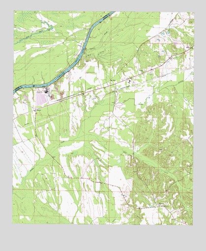
Jefferson, AL USGS Topographic Map
Click on map above to begin viewing in our Map Viewer.

This topographic map contains these locations and features:
Feature Name Type Latitude Longitude GNIS ID View Map
Allen CreekStreamN32.4260°W87.9550°113011View Map
Bethel ChurchChurchN32.4793°W87.9528°114052View Map
Bethel School (historical)SchoolN32.4793°W87.9533°134085View Map
Cypress CreekStreamN32.4779°W87.9503°116989View Map
Demopolis DivisionCivilN32.4256°W87.8864°165872View Map
Demopolis Regional AirportAirportN32.4615°W87.9536°129435View Map
Ellis Landing (historical)LocaleN32.4557°W87.9767°137602View Map
Falling CreekStreamN32.4571°W87.8886°118181View Map
Friendship Baptist ChurchChurchN32.4646°W87.9100°151781View Map
Gulf States Paper Company DamDamN32.4435°W87.9800°130586View Map
Gulf States Paper Company LakeReservoirN32.4476°W87.9815°130587View Map
JeffersonPopulated PlaceN32.3868°W87.8981°120829View Map
Jefferson ChurchChurchN32.3863°W87.8964°154785View Map
Jefferson Elementary School (historical)SchoolN32.3899°W87.9017°151616View Map
Jefferson Post OfficePost OfficeN32.3857°W87.8945°168681View Map
Jefferson Smalls CemeteryCemeteryN32.3874°W87.8995°1730253View Map
Jefferson Volunteer Fire DepartmentBuildingN32.3858°W87.8942°2691578View Map
Jems Landing (historical)LocaleN32.4654°W87.9642°134167View Map
John Essex High SchoolSchoolN32.4593°W87.9192°165417View Map
Mill CreekStreamN32.4754°W87.9511°122767View Map
Miller Church (historical)ChurchN32.4518°W87.9286°137635View Map
Miller's Chapel African Methodist Episcopal Zion ChurchChurchN32.4557°W87.9289°155414View Map
Millers Chapel CemeteryCemeteryN32.4546°W87.9286°1730259View Map
Millers School (historical)SchoolN32.4504°W87.9286°137636View Map
MoscowPopulated PlaceN32.4379°W87.9961°152385View Map
Moscow Church (historical)ChurchN32.4257°W87.9861°137638View Map
Moscow Providence ChurchChurchN32.4418°W87.9836°155415View Map
Mount Zion ChurchChurchN32.4787°W87.8775°123464View Map
New Hope ChurchChurchN32.4410°W87.9311°154784View Map
Paces (historical)Populated PlaceN32.4699°W87.9486°1730262View Map
Paces Landing EastLocaleN32.4724°W87.9533°137651View Map
Paces Landing WestLocaleN32.4685°W87.9603°134227View Map
PandoraLocaleN32.4732°W87.9561°134228View Map
Reeds Hunting LodgeBuildingN32.4857°W87.9886°134237View Map
Salt WellPopulated PlaceN32.4571°W87.9311°126271View Map
Simmons Landing (historical)LocaleN32.4946°W87.9417°134255View Map
Small Memorial African Methodist Episcopal Zion ChurchChurchN32.3907°W87.9008°154786View Map
Ulmers Landing (historical)LocaleN32.4657°W87.9606°137677View Map

Note: Coordinates in the location and feature list above are referenced to NAD83 datum.


Copyright (C) 2008-2024 Ryan Niemi / Sunset Dynamics ... All Rights Reserved