TopoQuest Logo
Do you find TopoQuest useful?
Help keep TopoQuest running and adding new maps/features by donating!
Bitcoin:  19c7KJd3qBynnjoSw5npx9KScwjBe4ifkT
Litecoin:  LXs6TkuXGGXo1vDsWCkWVdjQX94eUKd6ui
Home View Maps Find Maps Find Places Resources & Links


Coatopa, Alabama Topographic Map

USGS Map Title: Coatopa, AL
USGS Map MRC: 32088D1
DRG (GeoTIFF) Download: o32088d1.tif


Neighboring USGS Topographic Map Quads:


  Livingston, AL  
32088E2
 

  Brewersville, AL  
32088E1
 

  McDowell, AL  
32087E8
 

  Bellamy, AL  
32088D2
 

  Coatopa, AL  
32088D1
 

  Jefferson, AL  
32087D8
 

  Gaston, AL  
32088C2
 

  Whitfield, AL  
32088C1
 

  Myrtlewood North, AL  
32087C8


Map MRC Location:

N33°
W89°
N33°
W88°
H8 H7 H6 H5 H4 H3 H2 H1
G8 G7 G6 G5 G4 G3 G2 G1
F8 F7 F6 F5 F4 F3 F2 F1
E8 E7 E6 E5 E4 E3 E2 E1
D8 D7 D6 D5 D4 D3 D2 D1
C8 C7 C6 C5 C4 C3 C2 C1
B8 B7 B6 B5 B4 B3 B2 B1
A8 A7 A6 A5 A4 A3 A2 A1
N32°
W89°
N32°
W88°

Coatopa, AL USGS 1:24K Topographic Map Preview:
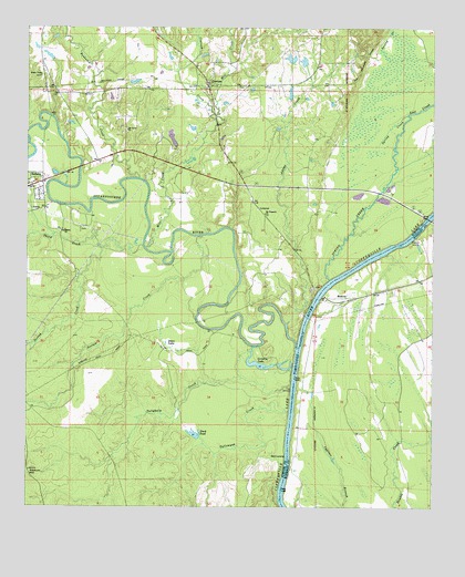
Coatopa, AL USGS Topographic Map
Click on map above to begin viewing in our Map Viewer.

This topographic map contains these locations and features:
Feature Name Type Latitude Longitude GNIS ID View Map
Adams CreekStreamN32.4229°W88.0447°112923View Map
Arrington (historical)Populated PlaceN32.4846°W88.1192°134076View Map
Bellamy ChurchChurchN32.4554°W88.1222°158421View Map
Black Bluff PrecinctCivilN32.4168°W88.0334°164488View Map
Buckhorn Camp (historical)LocaleN32.3988°W88.1222°134101View Map
Chaneys Landing (historical)LocaleN32.4468°W88.0042°137585View Map
Cheneys Lower Landing (historical)LocaleN32.4046°W88.0417°137586View Map
CoatopaPopulated PlaceN32.4851°W88.0695°116316View Map
Coatopa ChurchChurchN32.4879°W88.0725°134112View Map
Coatopa CreekStreamN32.4751°W88.0667°116317View Map
Coatopa Post OfficePost OfficeN32.4879°W88.0706°168859View Map
Dean LakeReservoirN32.4163°W88.0792°117178View Map
Deans LandingLocaleN32.3885°W88.0456°156258View Map
Duck PondLakeN32.3942°W88.0732°117617View Map
Dug Hill Volunteer Fire DepartmentBuildingN32.4866°W88.0691°2691607View Map
Friendship Baptist ChurchChurchN32.4474°W88.1134°157960View Map
Grinlin LakeReservoirN32.4127°W88.0537°119426View Map
Hearts Upper LandingLocaleN32.4288°W88.0347°137611View Map
Indian Queen BarBarN32.4385°W88.0209°137613View Map
Log LandingLocaleN32.4046°W88.0439°134179View Map
Lost CreekStreamN32.4774°W88.0081°122035View Map
Marys Chapel Baptist ChurchChurchN32.4876°W88.1209°158010View Map
Marys Chapel School (historical)SchoolN32.4876°W88.1209°134189View Map
Mcgregor DamDamN32.4685°W88.0784°130596View Map
Mcgregor LakeReservoirN32.4713°W88.0804°130595View Map
Mill CreekStreamN32.4426°W88.0884°122789View Map
Moscow Ferry (historical)CrossingN32.4310°W88.0345°137639View Map
Moscow Landing (historical)LocaleN32.4315°W88.0353°134196View Map
Mount Pleasant Baptist ChurchChurchN32.4515°W88.0517°158026View Map
Mount Pleasant School (historical)SchoolN32.4518°W88.0520°134205View Map
Mount Tabor Baptist ChurchChurchN32.4735°W88.0942°158030View Map
Mount Tabor CemeteryCemeteryN32.4732°W88.0942°1805619View Map
Mount Tabor School (historical)SchoolN32.4735°W88.0945°134207View Map
Pierces Landing (historical)LocaleN32.3957°W88.0450°134230View Map
Ponkabia CreekStreamN32.4607°W88.0903°153031View Map
Rooster BridgeBridgeN32.4310°W88.0345°125926View Map
Rooster Ridge Hunting LodgeBuildingN32.4376°W88.0517°134239View Map
Second CreekStreamN32.4429°W88.0892°126518View Map
Shady Grove School (historical)SchoolN32.4182°W88.0842°134250View Map
Soctum CreekStreamN32.4460°W88.0709°127092View Map
Soctum HillSummitN32.3846°W88.1242°127093View Map
Spring CreekStreamN32.4346°W88.0320°127229View Map
Sucarnoochee RiverStreamN32.4165°W88.0420°158934View Map
Tallawyah CreekStreamN32.4004°W88.0442°127647View Map
Tallyhaly CreekStreamN32.4071°W88.0436°127657View Map
Third CreekStreamN32.4426°W88.1022°127853View Map
Vouters LandingLocaleN32.4365°W88.0239°137679View Map

Note: Coordinates in the location and feature list above are referenced to NAD83 datum.


Copyright (C) 2008-2024 Ryan Niemi / Sunset Dynamics ... All Rights Reserved