TopoQuest Logo
Do you find TopoQuest useful?
Help keep TopoQuest running and adding new maps/features by donating!
Bitcoin:  19c7KJd3qBynnjoSw5npx9KScwjBe4ifkT
Litecoin:  LXs6TkuXGGXo1vDsWCkWVdjQX94eUKd6ui
Home View Maps Find Maps Find Places Resources & Links


Myrtlewood North, Alabama Topographic Map

USGS Map Title: Myrtlewood North, AL
USGS Map MRC: 32087C8
DRG (GeoTIFF) Download: o32087c8.tif


Neighboring USGS Topographic Map Quads:


  Coatopa, AL  
32088D1
 

  Jefferson, AL  
32087D8
 

  Old Spring Hill, AL  
32087D7
 

  Whitfield, AL  
32088C1
 

  Myrtlewood North, AL  
32087C8
 

  Linden, AL  
32087C7
 

  Pennington, AL  
32088B1
 

  Myrtlewood South, AL  
32087B8
 

  Miller, AL  
32087B7


Map MRC Location:

N33°
W88°
N33°
W87°
H8 H7 H6 H5 H4 H3 H2 H1
G8 G7 G6 G5 G4 G3 G2 G1
F8 F7 F6 F5 F4 F3 F2 F1
E8 E7 E6 E5 E4 E3 E2 E1
D8 D7 D6 D5 D4 D3 D2 D1
C8 C7 C6 C5 C4 C3 C2 C1
B8 B7 B6 B5 B4 B3 B2 B1
A8 A7 A6 A5 A4 A3 A2 A1
N32°
W88°
N32°
W87°

Myrtlewood North, AL USGS 1:24K Topographic Map Preview:
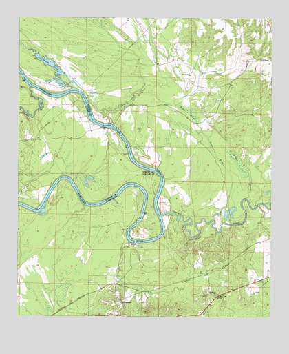
Myrtlewood North, AL USGS Topographic Map
Click on map above to begin viewing in our Map Viewer.

This topographic map contains these locations and features:
Feature Name Type Latitude Longitude GNIS ID View Map
Anopia (historical)LocaleN32.2715°W87.9042°137562View Map
Beckleys (historical)Populated PlaceN32.2829°W87.9281°1730242View Map
Beckleys BarBarN32.2824°W87.9411°163244View Map
Beckleys Landing (historical)LocaleN32.2849°W87.9278°137572View Map
Besteda Landing (historical)LocaleN32.3393°W87.9653°137575View Map
Blue Lock (historical)Populated PlaceN32.2885°W87.8897°1730243View Map
Brooklyn ChurchChurchN32.2599°W87.9028°114959View Map
Bryant Burns LandingLocaleN32.3124°W87.9333°137580View Map
Cedahoma (historical)Populated PlaceN32.3090°W87.9770°1730207View Map
Chickasaw BogueStreamN32.2926°W87.9292°155026View Map
Chickasaw Bogue Landing (historical)LocaleN32.2938°W87.9286°137587View Map
Clover Hill CemeteryCemeteryN32.2593°W87.9070°116282View Map
Cotahaga Landing (historical)LocaleN32.3438°W87.9892°134118View Map
Cotohaga CreekStreamN32.3463°W87.9939°116673View Map
Double BarBarN32.2960°W87.9872°137601View Map
Double CreekStreamN32.3457°W87.9736°117422View Map
Dustin SloughGutN32.3357°W87.9167°117693View Map
Four Mile BarBarN32.3021°W87.9508°140002View Map
GilmoresLocaleN32.3424°W87.9756°134145View Map
Greer BranchStreamN32.2904°W87.9025°119390View Map
Griffins (historical)Populated PlaceN32.3318°W87.9561°1730249View Map
Griffins Landing (historical)LocaleN32.3313°W87.9558°137608View Map
Hill TopPopulated PlaceN32.2596°W87.9003°120111View Map
Indian CreekStreamN32.3038°W87.9984°140027View Map
Jamison BranchStreamN32.3001°W87.8875°151882View Map
Jerusalem ChurchChurchN32.2590°W87.9017°120873View Map
Lewis Lower LandingLocaleN32.3079°W87.9797°140035View Map
Lewis Upper Landing (historical)LocaleN32.3371°W87.9639°137619View Map
Lock Number Three (historical)LocaleN32.3299°W87.9578°137626View Map
Lock Three Left Bank Public Use AreaParkN32.3313°W87.9578°166072View Map
Lock Three Right Bank Public Use AreaParkN32.3293°W87.9597°166042View Map
Lone Brothers BarBarN32.3451°W87.9739°137627View Map
Lost CreekStreamN32.2815°W87.9439°137628View Map
McNeals Landing (historical)LocaleN32.3046°W87.9281°137631View Map
McNeils (historical)Populated PlaceN32.3257°W87.9436°1730258View Map
Miles ShoalBarN32.2838°W87.9453°140053View Map
MyrtlewoodPopulated PlaceN32.2504°W87.9497°123626View Map
Myrtlewood Elementary School (historical)SchoolN32.2538°W87.9497°151618View Map
Myrtlewood Volunteer Fire DepartmentBuildingN32.2514°W87.9500°2691584View Map
New Macedonia ChurchChurchN32.3513°W87.9153°155174View Map
Nick Lewis BarBarN32.3068°W87.9795°140076View Map
Oak Tree LandingLocaleN32.3074°W87.9764°137647View Map
Oakchi Landing East (historical)LocaleN32.2935°W87.9908°137648View Map
Port Clarion (historical)LocaleN32.2826°W87.9292°137655View Map
Rainwater (historical)LocaleN32.3099°W87.9278°137659View Map
Rainwater BarBarN32.3010°W87.9297°137660View Map
Rembert LandingLocaleN32.2863°W87.9461°137661View Map
Remberts BarBarN32.2965°W87.9647°137663View Map
Remberts LandingLocaleN32.2960°W87.9639°1730264View Map
Rentz Ferry (historical)CrossingN32.2810°W87.9425°140101View Map
Robert Emmet BarBarN32.2574°W87.9314°140104View Map
Robertson LandingLocaleN32.3449°W87.9714°137665View Map
Shady Grove (historical)LocaleN32.3488°W87.9722°137669View Map
Silmares Landing (historical)LocaleN32.3413°W87.9845°134254View Map
Sixmile CreekStreamN32.2957°W87.8750°126919View Map
Sixmile CreekStreamN32.3313°W87.9553°153458View Map
Smith IslandIslandN32.3099°W87.9311°140130View Map
Town of MyrtlewoodCivilN32.2521°W87.9493°2406222View Map

Note: Coordinates in the location and feature list above are referenced to NAD83 datum.


Copyright (C) 2008-2025 Ryan Niemi / Sunset Dynamics ... All Rights Reserved