TopoQuest Logo
Do you find TopoQuest useful?
Help keep TopoQuest running and adding new maps/features by donating!
Bitcoin:  19c7KJd3qBynnjoSw5npx9KScwjBe4ifkT
Litecoin:  LXs6TkuXGGXo1vDsWCkWVdjQX94eUKd6ui
Home View Maps Find Maps Find Places Resources & Links


Jemez Springs, New Mexico Topographic Map

USGS Map Title: Jemez Springs, NM
USGS Map MRC: 35106G6
DRG (GeoTIFF) Download: o35106g6.tif


Neighboring USGS Topographic Map Quads:


  Rancho del Chaparral, NM  
35106H7
 

  Seven Springs, NM  
35106H6
 

  Valle San Antonio, NM  
35106H5
 

  San Miguel Mountain, NM  
35106G7
 

  Jemez Springs, NM  
35106G6
 

  Redondo Peak, NM  
35106G5
 

  Gilman, NM  
35106F7
 

  Ponderosa, NM  
35106F6
 

  Bear Springs Peak, NM  
35106F5


Map MRC Location:

N36°
W107°
N36°
W106°
H8 H7 H6 H5 H4 H3 H2 H1
G8 G7 G6 G5 G4 G3 G2 G1
F8 F7 F6 F5 F4 F3 F2 F1
E8 E7 E6 E5 E4 E3 E2 E1
D8 D7 D6 D5 D4 D3 D2 D1
C8 C7 C6 C5 C4 C3 C2 C1
B8 B7 B6 B5 B4 B3 B2 B1
A8 A7 A6 A5 A4 A3 A2 A1
N35°
W107°
N35°
W106°

Jemez Springs, NM USGS 1:24K Topographic Map Preview:
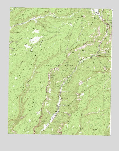
Jemez Springs, NM USGS Topographic Map
Click on map above to begin viewing in our Map Viewer.

This topographic map contains these locations and features:
Feature Name Type Latitude Longitude GNIS ID View Map
Agua Durme SpringSpringN35.8072°W106.6987°902445View Map
Alamo SpringSpringN35.8311°W106.6708°903049View Map
Amoxiumqua Historic SiteLocaleN35.7686°W106.6923°933555View Map
Aqua Durme SpringsSpringN35.8082°W106.6996°903250View Map
Battleship RockSummitN35.8284°W106.6423°903611View Map
Battleship Rock Recreation SiteLocaleN35.8284°W106.6436°936783View Map
Camp ShaverLocaleN35.8284°W106.6445°2038395View Map
Caņon de San Diego GrantCivilN35.8184°W106.6975°918117View Map
Cass TankReservoirN35.8444°W106.7245°897538View Map
Cat MesaBenchN35.7789°W106.6706°918126View Map
Cebollita MesaSummitN35.8631°W106.6559°904859View Map
Cebollita SpringSpringN35.8320°W106.7234°887311View Map
Cebollita TankReservoirN35.8509°W106.6898°904860View Map
Cerro ColoradoSummitN35.8172°W106.6517°918136View Map
Church CanyonValleyN35.7772°W106.6881°905141View Map
Dark Canyon Picnic GroundLocaleN35.8531°W106.6311°2038431View Map
East Fork Jemez RiverStreamN35.8281°W106.6448°918170View Map
Giusewa Historic SiteLocaleN35.7786°W106.6864°934265View Map
Guacamayo Historic SiteLocaleN35.7686°W106.6923°933738View Map
Hanakwa Historic SiteLocaleN35.8275°W106.7417°933746View Map
Hole A Water WellWellN35.8714°W106.6681°922721View Map
Holiday MesaBenchN35.8184°W106.7286°907026View Map
Hot Springs Pueblo Historic SiteLocaleN35.8284°W106.6436°933755View Map
Hummingbird CampLocaleN35.8234°W106.6609°907165View Map
Indian Head Picnic GroundLocaleN35.8414°W106.6386°915958View Map
Jemez Canyon OverlookLocaleN35.8592°W106.6281°907343View Map
Jemez Hot SpringsSpringN35.7703°W106.6928°914276View Map
Jemez Hot SpringsSpringN35.7722°W106.6908°914422View Map
Jemez Hot SpringsMineN35.7750°W106.7159°916252View Map
Jemez Hot Springs Mineral Bath House Historic SiteBuildingN35.7686°W106.6923°935206View Map
Jemez Hot Springs Original SpringsSpringN35.7733°W106.6895°914428View Map
Jemez Mountains Historical MarkerParkN35.7686°W106.6923°932313View Map
Jemez Ranger DistrictForestN35.7670°W106.6325°2038515View Map
Jemez Ranger StationLocaleN35.7861°W106.6867°907345View Map
Jemez SpringsPopulated PlaceN35.7686°W106.6923°918208View Map
Jemez Springs Catholic CemeteryCemeteryN35.7682°W106.6923°931224View Map
Jemez Springs Police DepartmentBuildingN35.7720°W106.6905°2722522View Map
Jemez Springs Post OfficePost OfficeN35.7630°W106.6974°938071View Map
Jemez Springs Volunteer Fire DepartmentBuildingN35.7606°W106.6986°2657579View Map
Jemez Springs Weather StationLocaleN35.7686°W106.6923°931771View Map
Jemez State MonumentParkN35.7786°W106.6864°936782View Map
Jemez Valley Medical ClinicHospitalN35.7686°W106.6923°901291View Map
Jemez-Zia DivisionCivilN35.7597°W106.7038°1937544View Map
Kiashita Historic SiteLocaleN35.8275°W106.7417°933779View Map
Kwastiyukwa RuinLocaleN35.7686°W106.6923°936044View Map
LA 44000LocaleN35.7686°W106.6917°935902View Map
LA 5918LocaleN35.7686°W106.6917°936043View Map
La CuevaPopulated PlaceN35.8742°W106.6439°902763View Map
La Cueva CampgroundLocaleN35.8636°W106.6367°907633View Map
La Cueva Census Designated PlaceCensusN35.8694°W106.6485°2584123View Map
La Cueva Guard StationLocaleN35.8700°W106.6409°907639View Map
La Cueva Volunteer Fire DepartmentBuildingN35.8739°W106.6439°2657723View Map
La Plata PlacerMineN35.8481°W106.6298°915593View Map
Lake Fork MesaSummitN35.8717°W106.7128°918225View Map
Lower Vallecito DamDamN35.7767°W106.6506°924079View Map
Lower Vallecito ReservoirReservoirN35.7767°W106.6506°924080View Map
McCauley SpringSpringN35.8200°W106.6274°914324View Map
Nanishagi RuinLocaleN35.7686°W106.6923°935997View Map
NE Soda Dam ProspectMineN35.7922°W106.6770°916284View Map
Ojito CanyonValleyN35.7731°W106.6898°909265View Map
Padre Alonzo TrailTrailN35.7786°W106.6731°909434View Map
Pejunkwa RuinLocaleN35.7686°W106.6923°935953View Map
Perea (historical)LocaleN35.8636°W106.6367°902772View Map
Redondo CampgroundLocaleN35.8634°W106.6261°910094View Map
Rincon NegroPillarN35.8339°W106.6589°910203View Map
San Antonio CreekStreamN35.8281°W106.6450°928798View Map
Schoolhouse MesaSummitN35.8545°W106.7214°910876View Map
Sino SpringSpringN35.8214°W106.6787°911091View Map
Soda DamArchN35.7914°W106.6864°911188View Map
Soda Dam Historical MarkerParkN35.7914°W106.6864°932799View Map
Soda Dam SpringsMineN35.7945°W106.6867°916253View Map
Soda Dam Springs EastSpringN35.7914°W106.6868°902654View Map
Soda Dam Springs WestSpringN35.7917°W106.6870°902444View Map
Spence Hot SpringSpringN35.8494°W106.6292°914429View Map
Spring CanyonValleyN35.8745°W106.7470°918372View Map
Stable MesaBenchN35.8275°W106.7417°911380View Map
Sulphur CreekStreamN35.8659°W106.6389°918373View Map
Tent RocksSlopeN35.8675°W106.6609°911609View Map
Totaskwinu RuinLocaleN35.7686°W106.6923°935994View Map
Tovakwa RuinLocaleN35.7686°W106.6923°935954View Map
Unshagi RuinLocaleN35.7686°W106.6923°935952View Map
Valle Grande Historical MarkerParkN35.8634°W106.6261°932801View Map
Via Coeli MonasteryChurchN35.7781°W106.6895°912098View Map
Village of Jemez SpringsCivilN35.7734°W106.6907°2413562View Map
Virgin MesaBenchN35.7903°W106.7156°912116View Map
Wabakwa RuinLocaleN35.7686°W106.6923°935996View Map
West MesaBenchN35.7892°W106.7270°912250View Map
Wildcat CanyonValleyN35.8689°W106.6411°912380View Map

Note: Coordinates in the location and feature list above are referenced to NAD83 datum.


Copyright (C) 2008-2025 Ryan Niemi / Sunset Dynamics ... All Rights Reserved