TopoQuest Logo
Do you find TopoQuest useful?
Help keep TopoQuest running and adding new maps/features by donating!
Bitcoin:  19c7KJd3qBynnjoSw5npx9KScwjBe4ifkT
Litecoin:  LXs6TkuXGGXo1vDsWCkWVdjQX94eUKd6ui
Home View Maps Find Maps Find Places Resources & Links


Jerico Springs, Missouri Topographic Map

USGS Map Title: Jerico Springs, MO
USGS Map MRC: 37094E1
DRG (GeoTIFF) Download: o37094e1.tif


Neighboring USGS Topographic Map Quads:


  Bellamy, MO  
37094F2
 

  Montevallo, MO  
37094F1
 

  Wagoner, MO  
37093F8
 

  Milford, MO  
37094E2
 

  Jerico Springs, MO  
37094E1
 

  Cedarville, MO  
37093E8
 

  Kenoma, MO  
37094D2
 

  Golden City, MO  
37094D1
 

  Lockwood, MO  
37093D8


Map MRC Location:

N38°
W95°
N38°
W94°
H8 H7 H6 H5 H4 H3 H2 H1
G8 G7 G6 G5 G4 G3 G2 G1
F8 F7 F6 F5 F4 F3 F2 F1
E8 E7 E6 E5 E4 E3 E2 E1
D8 D7 D6 D5 D4 D3 D2 D1
C8 C7 C6 C5 C4 C3 C2 C1
B8 B7 B6 B5 B4 B3 B2 B1
A8 A7 A6 A5 A4 A3 A2 A1
N37°
W95°
N37°
W94°

Jerico Springs, MO USGS 1:24K Topographic Map Preview:
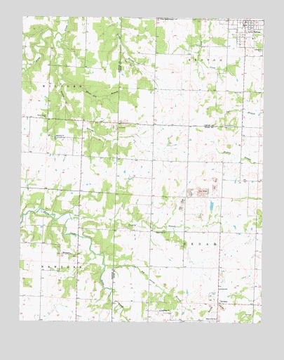
Jerico Springs, MO USGS Topographic Map
Click on map above to begin viewing in our Map Viewer.

This topographic map contains these locations and features:
Feature Name Type Latitude Longitude GNIS ID View Map
Anna-Edna CemeteryCemeteryN37.6120°W94.0013°713301View Map
Banner School (historical)SchoolN37.5295°W94.0041°746254View Map
Bethlehem ChurchChurchN37.5048°W94.0522°714094View Map
Big George BranchStreamN37.5000°W94.0297°714166View Map
Campbell Lake DamDamN37.5467°W94.0736°762980View Map
Chaney BranchStreamN37.5423°W94.0991°715718View Map
Don Henley LakeReservoirN37.5480°W94.0266°763265View Map
English School (historical)SchoolN37.5762°W94.1102°746186View Map
Flory (historical)Populated PlaceN37.5664°W94.0574°740059View Map
German CemeteryCemeteryN37.5948°W94.0113°718411View Map
Ginger Hill School (historical)SchoolN37.5579°W94.1214°746187View Map
Greenfield CemeteryCemeteryN37.5811°W94.0208°718822View Map
Greer School (historical)SchoolN37.6192°W94.0919°746185View Map
Harmony ChurchChurchN37.5762°W94.1072°719109View Map
Jerico SpringsPopulated PlaceN37.6223°W94.0086°729910View Map
Jerico Springs Fire DepartmentBuildingN37.6219°W94.0108°2620956View Map
Jerico Springs Post OfficePost OfficeN37.6222°W94.0097°2779502View Map
Maple Grove ChurchChurchN37.5017°W94.0236°721822View Map
Mitchell School (historical)SchoolN37.5984°W94.0247°746237View Map
NewportPopulated PlaceN37.5278°W94.1044°729935View Map
Newport School (historical)SchoolN37.5282°W94.1041°745770View Map
Number 706 DamDamN37.5684°W94.0886°763253View Map
Paragon School (historical)SchoolN37.5656°W94.0238°746251View Map
Patton BranchStreamN37.6164°W94.1041°724095View Map
Pleasant View School (historical)SchoolN37.5950°W94.0569°746236View Map
Rockdale School (historical)SchoolN37.5600°W94.0577°746256View Map
Round Prairie CemeteryCemeteryN37.5753°W94.1085°725614View Map
Round Prairie School (historical)SchoolN37.5833°W94.1125°725617View Map
Star School (historical)SchoolN37.5112°W94.0230°746253View Map
Stony Point ChurchChurchN37.5367°W94.0499°727152View Map
Stony Point School (historical)SchoolN37.5370°W94.0491°746255View Map
Sunshine School (historical)SchoolN37.5067°W94.0583°746252View Map
SylvaniaPopulated PlaceN37.5078°W94.0227°727423View Map
Sylvania School (historical)SchoolN37.5137°W94.0219°727424View Map
Township of CedarCivilN37.5272°W94.0204°766549View Map
Township of MilfordCivilN37.5980°W94.1205°766281View Map
Township of NewportCivilN37.5106°W94.1231°766283View Map
Village of Jerico SpringsCivilN37.6196°W94.0114°2398297View Map
West IndependenceLocaleN37.6245°W94.0547°728589View Map
White Oak BranchStreamN37.5992°W94.1044°728738View Map
Winningham Lake DamDamN37.5467°W94.0269°763264View Map

Note: Coordinates in the location and feature list above are referenced to NAD83 datum.


Copyright (C) 2008-2025 Ryan Niemi / Sunset Dynamics ... All Rights Reserved