TopoQuest Logo
Do you find TopoQuest useful?
Help keep TopoQuest running and adding new maps/features by donating!
Bitcoin:  19c7KJd3qBynnjoSw5npx9KScwjBe4ifkT
Litecoin:  LXs6TkuXGGXo1vDsWCkWVdjQX94eUKd6ui
Home View Maps Find Maps Find Places Resources & Links


Bellamy, Missouri Topographic Map

USGS Map Title: Bellamy, MO
USGS Map MRC: 37094F2
DRG (GeoTIFF) Download: o37094f2.tif


Neighboring USGS Topographic Map Quads:


  Nevada, MO  
37094G3
 

  Dederick, MO  
37094G2
 

  El Dorado Springs South, MO  
37094G1
 

  Sheldon, MO  
37094F3
 

  Bellamy, MO  
37094F2
 

  Montevallo, MO  
37094F1
 

  Lamar North, MO  
37094E3
 

  Milford, MO  
37094E2
 

  Jerico Springs, MO  
37094E1


Map MRC Location:

N38°
W95°
N38°
W94°
H8 H7 H6 H5 H4 H3 H2 H1
G8 G7 G6 G5 G4 G3 G2 G1
F8 F7 F6 F5 F4 F3 F2 F1
E8 E7 E6 E5 E4 E3 E2 E1
D8 D7 D6 D5 D4 D3 D2 D1
C8 C7 C6 C5 C4 C3 C2 C1
B8 B7 B6 B5 B4 B3 B2 B1
A8 A7 A6 A5 A4 A3 A2 A1
N37°
W95°
N37°
W94°

Bellamy, MO USGS 1:24K Topographic Map Preview:
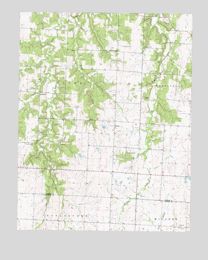
Bellamy, MO USGS Topographic Map
Click on map above to begin viewing in our Map Viewer.

This topographic map contains these locations and features:
Feature Name Type Latitude Longitude GNIS ID View Map
Arbor Grove CemeteryCemeteryN37.7309°W94.1597°713367View Map
BellamyPopulated PlaceN37.6850°W94.1805°729842View Map
Bellamy School (historical)SchoolN37.6875°W94.1863°746160View Map
Blanchards LakeReservoirN37.6417°W94.1986°762968View Map
Claflin Lake DamDamN37.6417°W94.1986°762967View Map
Dunnegan Grove CemeteryCemeteryN37.6711°W94.1716°2572605View Map
Dunnegan Grove ChurchChurchN37.6706°W94.1713°717194View Map
Little Clear CreekStreamN37.7153°W94.2291°721190View Map
New Harmony School (historical)SchoolN37.7148°W94.1438°746159View Map
Olive Branch CemeteryCemeteryN37.7311°W94.1752°723805View Map
Olive Branch ChurchChurchN37.7281°W94.1791°723807View Map
Phillips School (historical)SchoolN37.7223°W94.2436°746156View Map
Pleasant Plain School (historical)SchoolN37.6589°W94.1919°746162View Map
Pottorf Lake DamDamN37.6684°W94.2069°763213View Map
RousertownPopulated PlaceN37.7031°W94.2349°740015View Map
Saint James CemeteryCemeteryN37.6282°W94.1324°2681299View Map
Saint James ChurchChurchN37.6281°W94.1327°725754View Map
Science Hill School (historical)SchoolN37.7231°W94.1619°746158View Map
Stone Front School (historical)SchoolN37.6642°W94.1463°746161View Map
Tolson CemeteryCemeteryN37.6795°W94.2330°727700View Map
Township of DoverCivilN37.7025°W94.2169°767485View Map
Walnut CreekStreamN37.7442°W94.2086°728292View Map
Warwick CemeteryCemeteryN37.6742°W94.2399°728366View Map
Warwick School (historical)SchoolN37.6895°W94.2355°746157View Map
WiseBuildingN37.6281°W94.1308°745772View Map

Note: Coordinates in the location and feature list above are referenced to NAD83 datum.


Copyright (C) 2008-2024 Ryan Niemi / Sunset Dynamics ... All Rights Reserved