TopoQuest Logo
Do you find TopoQuest useful?
Help keep TopoQuest running and adding new maps/features by donating!
Bitcoin:  19c7KJd3qBynnjoSw5npx9KScwjBe4ifkT
Litecoin:  LXs6TkuXGGXo1vDsWCkWVdjQX94eUKd6ui
Home View Maps Find Maps Find Places Resources & Links


Milford, Missouri Topographic Map

USGS Map Title: Milford, MO
USGS Map MRC: 37094E2
DRG (GeoTIFF) Download: o37094e2.tif


Neighboring USGS Topographic Map Quads:


  Sheldon, MO  
37094F3
 

  Bellamy, MO  
37094F2
 

  Montevallo, MO  
37094F1
 

  Lamar North, MO  
37094E3
 

  Milford, MO  
37094E2
 

  Jerico Springs, MO  
37094E1
 

  Lamar South, MO  
37094D3
 

  Kenoma, MO  
37094D2
 

  Golden City, MO  
37094D1


Map MRC Location:

N38°
W95°
N38°
W94°
H8 H7 H6 H5 H4 H3 H2 H1
G8 G7 G6 G5 G4 G3 G2 G1
F8 F7 F6 F5 F4 F3 F2 F1
E8 E7 E6 E5 E4 E3 E2 E1
D8 D7 D6 D5 D4 D3 D2 D1
C8 C7 C6 C5 C4 C3 C2 C1
B8 B7 B6 B5 B4 B3 B2 B1
A8 A7 A6 A5 A4 A3 A2 A1
N37°
W95°
N37°
W94°

Milford, MO USGS 1:24K Topographic Map Preview:
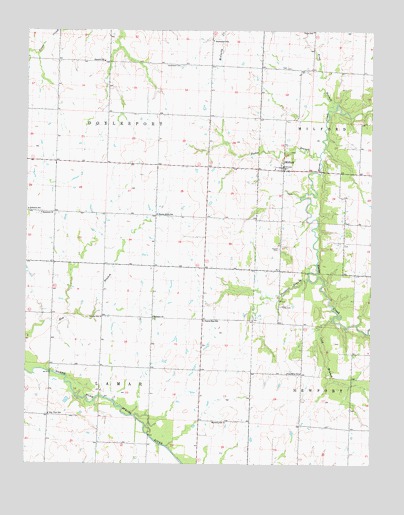
Milford, MO USGS Topographic Map
Click on map above to begin viewing in our Map Viewer.

This topographic map contains these locations and features:
Feature Name Type Latitude Longitude GNIS ID View Map
Anderson School (historical)SchoolN37.5734°W94.2494°713292View Map
Bethany ChurchChurchN37.5425°W94.2038°714018View Map
Cass DamDamN37.5667°W94.2252°763251View Map
Cass LakeReservoirN37.5668°W94.2252°763252View Map
Charles Wood DamDamN37.6217°W94.1852°763036View Map
Cherry Grove School (historical)SchoolN37.5720°W94.2027°715764View Map
City View School (historical)SchoolN37.5142°W94.2416°715858View Map
Cold BranchStreamN37.5420°W94.1391°716078View Map
Cook CemeteryCemeteryN37.5461°W94.1566°716216View Map
Doylesport CemeteryCemeteryN37.6150°W94.1930°717039View Map
Doylesport School (historical)SchoolN37.6222°W94.1831°717040View Map
Emberry LakeReservoirN37.5467°W94.2469°762982View Map
Embery Lake DamDamN37.5467°W94.2469°762981View Map
Friendship School (historical)SchoolN37.5264°W94.1505°718249View Map
Harmony School (historical)SchoolN37.5122°W94.1778°719121View Map
Hopewell ChurchChurchN37.5723°W94.2447°719801View Map
Howell CemeteryCemeteryN37.5623°W94.1585°719928View Map
Hyder BranchStreamN37.5889°W94.1438°720062View Map
MilfordPopulated PlaceN37.5848°W94.1572°722316View Map
Milford School (historical)SchoolN37.5853°W94.1605°746184View Map
Painter BranchStreamN37.5539°W94.1480°723966View Map
Prairie Rose School (historical)SchoolN37.5414°W94.1855°724876View Map
Ring BranchStreamN37.6034°W94.1383°725316View Map
Summit School (historical)SchoolN37.6162°W94.2222°727294View Map
Township of DoylesportCivilN37.6015°W94.2205°766277View Map
Valley School (historical)SchoolN37.6248°W94.1467°728101View Map
Victory School (historical)SchoolN37.5423°W94.2227°728193View Map
Village of MilfordCivilN37.5863°W94.1582°2399345View Map
Wood LakeReservoirN37.6217°W94.1852°763037View Map
Wood Lake DamDamN37.6217°W94.1802°763543View Map

Note: Coordinates in the location and feature list above are referenced to NAD83 datum.


Copyright (C) 2008-2024 Ryan Niemi / Sunset Dynamics ... All Rights Reserved