TopoQuest Logo
Do you find TopoQuest useful?
Help keep TopoQuest running and adding new maps/features by donating!
Bitcoin:  19c7KJd3qBynnjoSw5npx9KScwjBe4ifkT
Litecoin:  LXs6TkuXGGXo1vDsWCkWVdjQX94eUKd6ui
Home View Maps Find Maps Find Places Resources & Links


Montevallo, Missouri Topographic Map

USGS Map Title: Montevallo, MO
USGS Map MRC: 37094F1
DRG (GeoTIFF) Download: o37094f1.tif


Neighboring USGS Topographic Map Quads:


  Dederick, MO  
37094G2
 

  El Dorado Springs South, MO  
37094G1
 

  Filley, MO  
37093G8
 

  Bellamy, MO  
37094F2
 

  Montevallo, MO  
37094F1
 

  Wagoner, MO  
37093F8
 

  Milford, MO  
37094E2
 

  Jerico Springs, MO  
37094E1
 

  Cedarville, MO  
37093E8


Map MRC Location:

N38°
W95°
N38°
W94°
H8 H7 H6 H5 H4 H3 H2 H1
G8 G7 G6 G5 G4 G3 G2 G1
F8 F7 F6 F5 F4 F3 F2 F1
E8 E7 E6 E5 E4 E3 E2 E1
D8 D7 D6 D5 D4 D3 D2 D1
C8 C7 C6 C5 C4 C3 C2 C1
B8 B7 B6 B5 B4 B3 B2 B1
A8 A7 A6 A5 A4 A3 A2 A1
N37°
W95°
N37°
W94°

Montevallo, MO USGS 1:24K Topographic Map Preview:
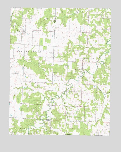
Montevallo, MO USGS Topographic Map
Click on map above to begin viewing in our Map Viewer.

This topographic map contains these locations and features:
Feature Name Type Latitude Longitude GNIS ID View Map
Barnes School (historical)SchoolN37.7009°W94.0438°746219View Map
Bear CreekStreamN37.6848°W94.0222°713794View Map
Boggy Springs School (historical)SchoolN37.6428°W94.0330°746216View Map
Brasher CemeteryCemeteryN37.6389°W94.0263°714647View Map
Cynthia CreekStreamN37.6567°W94.0741°729867View Map
Diamond Grove School (historical)SchoolN37.7089°W94.0891°746163View Map
Fair View School (historical)SchoolN37.6675°W94.0361°746217View Map
Glade Springs ChurchChurchN37.6867°W94.0711°718483View Map
Glade Springs School (historical)SchoolN37.6698°W94.0819°746164View Map
Green Ridge School (historical)SchoolN37.7350°W94.0286°746220View Map
Hall BranchStreamN37.6648°W94.0066°719001View Map
Hall School (historical)SchoolN37.6823°W94.0022°746218View Map
Hicklin CreekStreamN37.7150°W94.0052°719420View Map
Independence School (historical)SchoolN37.6253°W94.0549°746215View Map
Jordan CreekStreamN37.6412°W94.0113°739494View Map
Lacey BranchStreamN37.6337°W94.0816°720724View Map
Little Bear CreekStreamN37.7489°W94.0255°748510View Map
Mapies BranchStreamN37.6517°W94.0058°721846View Map
MontevalloPopulated PlaceN37.7262°W94.1083°722539View Map
Montevallo Academy (historical)SchoolN37.7292°W94.1226°745742View Map
Number 658 DamDamN37.6426°W94.1203°763195View Map
Oldham CemeteryCemeteryN37.6798°W94.0277°723798View Map
OlympiaPopulated PlaceN37.7262°W94.0286°741119View Map
Olympia Rural Fire DepartmentBuildingN37.7322°W94.0287°2621701View Map
OsirisPopulated PlaceN37.6678°W94.0358°740055View Map
Potter BranchStreamN37.7134°W94.0011°724790View Map
Tom BranchStreamN37.6634°W94.0602°727703View Map
Township of BentonCivilN37.6670°W94.0082°766449View Map
Township of MontevalloCivilN37.6993°W94.1165°767491View Map
Walnut Grove CemeteryCemeteryN37.7306°W94.0691°728302View Map
Walnut Grove School (historical)SchoolN37.7348°W94.0691°746221View Map
Wieland BranchStreamN37.7420°W94.0563°748538View Map
Wilkey CreekStreamN37.6748°W94.0547°728865View Map
ZodiacPopulated PlaceN37.6470°W94.0922°740050View Map
Zodiac School (historical)SchoolN37.6470°W94.0919°746165View Map

Note: Coordinates in the location and feature list above are referenced to NAD83 datum.


Copyright (C) 2008-2024 Ryan Niemi / Sunset Dynamics ... All Rights Reserved