TopoQuest Logo
Do you find TopoQuest useful?
Help keep TopoQuest running and adding new maps/features by donating!
Bitcoin:  19c7KJd3qBynnjoSw5npx9KScwjBe4ifkT
Litecoin:  LXs6TkuXGGXo1vDsWCkWVdjQX94eUKd6ui
Home View Maps Find Maps Find Places Resources & Links


Ball, Louisiana Topographic Map

USGS Map Title: Ball, LA
USGS Map MRC: 31092D4
DRG (GeoTIFF) Download: o31092d4.tif


Neighboring USGS Topographic Map Quads:


  Dry Prong, LA  
31092E5
 

  Pollock, LA  
31092E4
 

  Fishville, LA  
31092E3
 

  Rock Hill, LA  
31092D5
 

  Ball, LA  
31092D4
 

  Green Gables, LA  
31092D3
 

  Rapides, LA  
31092C5
 

  Alexandria, LA  
31092C4
 

  Libuse, LA  
31092C3


Map MRC Location:

N32°
W93°
N32°
W92°
H8 H7 H6 H5 H4 H3 H2 H1
G8 G7 G6 G5 G4 G3 G2 G1
F8 F7 F6 F5 F4 F3 F2 F1
E8 E7 E6 E5 E4 E3 E2 E1
D8 D7 D6 D5 D4 D3 D2 D1
C8 C7 C6 C5 C4 C3 C2 C1
B8 B7 B6 B5 B4 B3 B2 B1
A8 A7 A6 A5 A4 A3 A2 A1
N31°
W93°
N31°
W92°

Ball, LA USGS 1:24K Topographic Map Preview:
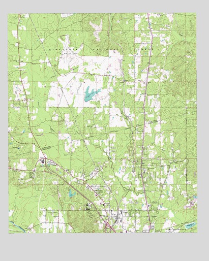
Ball, LA USGS Topographic Map
Click on map above to begin viewing in our Map Viewer.

This topographic map contains these locations and features:
Feature Name Type Latitude Longitude GNIS ID View Map
Alpine Christian SchoolSchoolN31.4141°W92.4682°2462745View Map
Alpine Volunteer Fire Department Station 1BuildingN31.4167°W92.4803°2673147View Map
Alpine Volunteer Fire Department Station 2BuildingN31.3831°W92.4322°2672906View Map
Alpine Volunteer Fire Department Station 3BuildingN31.3815°W92.4710°2672996View Map
Apostolic ChurchChurchN31.3766°W92.4157°546982View Map
Bacon BranchStreamN31.4535°W92.4807°546990View Map
BallPopulated PlaceN31.4155°W92.4118°546993View Map
Ball Elementary SchoolSchoolN31.4179°W92.4045°551814View Map
Ball Post OfficePost OfficeN31.4086°W92.4116°1631706View Map
Ball Town City Police DepartmentBuildingN31.4074°W92.4097°2755337View Map
Ball Volunteer Fire Department Station 1BuildingN31.4074°W92.4097°2672777View Map
Ball Volunteer Fire Department Station 2BuildingN31.4170°W92.4179°2673098View Map
Ball Volunteer Fire Department Station 3BuildingN31.4173°W92.4178°2673100View Map
Bentley ChurchChurchN31.4977°W92.4926°547057View Map
Camp CookMilitaryN31.4100°W92.4106°2512400View Map
Catahoula Work CenterLocaleN31.4988°W92.4590°548220View Map
Central ChurchChurchN31.3846°W92.4674°547205View Map
Christian ChapelChurchN31.4152°W92.3876°548222View Map
Clear Creek CampgroundLocaleN31.4807°W92.3829°548219View Map
Cornith ChurchChurchN31.4727°W92.4943°547250View Map
Dry ProngStreamN31.4166°W92.4332°554277View Map
Faith Baptist ChurchChurchN31.4085°W92.4499°554380View Map
Federal Correctional Institution PollockBuildingN31.4667°W92.4461°2739781View Map
Forest Lawn Memorial ParkCemeteryN31.3760°W92.4054°547369View Map
Garnett (historical)Populated PlaceN31.4627°W92.4676°545768View Map
Handley Loop ChurchChurchN31.3849°W92.4362°547433View Map
Haw CreekStreamN31.3882°W92.3926°547451View Map
Highland ChurchChurchN31.3849°W92.4465°547462View Map
Hosanna Baptist ChurchChurchN31.3988°W92.4107°554784View Map
Hudson Creek ChurchChurchN31.4110°W92.4968°551720View Map
Hudson Creek Siding (historical)LocaleN31.4280°W92.4501°551721View Map
Jena Band of Choctaw ReservationCivilN31.4379°W92.4988°2453210View Map
Kisatchie LakeReservoirN31.4540°W92.4454°556894View Map
Kisatchie Lake DamDamN31.4535°W92.4468°556893View Map
Kitchen CreekStreamN31.4121°W92.4310°547550View Map
Kitchen Creek ChurchChurchN31.4332°W92.4110°547551View Map
KLAA-FM (Tioga)TowerN31.4363°W92.4971°1633117View Map
KLAA-FM (Tioga)TowerN31.4277°W92.4051°1633118View Map
KWDF-AM (Ball)TowerN31.3782°W92.4743°1633149View Map
Labat CemeteryCemeteryN31.3774°W92.4857°548221View Map
Louisiana Noname Number 53 DamDamN31.4335°W92.4885°556895View Map
Louisiana State Industrial SchoolSchoolN31.4107°W92.4099°548223View Map
Louisiana Training Institute for GirlsSchoolN31.4096°W92.4099°551735View Map
Mary Goff Elementary SchoolSchoolN31.4108°W92.4615°1629648View Map
NugentPopulated PlaceN31.4410°W92.4212°547781View Map
ParadisePopulated PlaceN31.3841°W92.4071°547815View Map
Paradise Elementary SchoolSchoolN31.3906°W92.4076°1629745View Map
Parish Governing Authority District 6CivilN31.4785°W92.4140°1930135View Map
Parish Governing Authority District ACivilN31.4003°W92.4183°1930296View Map
Pilgrim ChurchChurchN31.4613°W92.4118°547835View Map
Pinehurst Baptist ChurchChurchN31.4130°W92.3996°555667View Map
Pollock Army Air Field (historical)MilitaryN31.4769°W92.4592°2085460View Map
Pollock Municipal AirportAirportN31.4758°W92.4612°2085462View Map
ProspectPopulated PlaceN31.4505°W92.4876°545797View Map
Prospect Census Designated PlaceCensusN31.4488°W92.4969°2586703View Map
Rapides Parish Sheriff's Office SubstationBuildingN31.3831°W92.4322°2755245View Map
Rigolette Ward TenCivilN31.3796°W92.4135°545177View Map
SimmsPopulated PlaceN31.4613°W92.4235°547998View Map
South Sarepta Oil and Gas FieldChurchN31.4143°W92.4682°555979View Map
Springhill ChurchChurchN31.4349°W92.4440°548025View Map
StayPopulated PlaceN31.4724°W92.4921°548034View Map
Timber TrailsPopulated PlaceN31.4082°W92.4846°551790View Map
TiogaPopulated PlaceN31.3871°W92.4257°556251View Map
Tioga Elementary SchoolSchoolN31.3779°W92.4151°551875View Map
Tioga First Baptist ChurchChurchN31.3877°W92.4318°551876View Map
Tioga High SchoolSchoolN31.3817°W92.4258°551791View Map
Tioga Junior High SchoolSchoolN31.3869°W92.4255°551792View Map
Town of BallCivilN31.4188°W92.4084°2405204View Map
Town of PollockCivilN31.4985°W92.4432°2407142View Map
United ChurchChurchN31.4174°W92.4010°548113View Map
United States Penitentiary PollockBuildingN31.4697°W92.4382°2739782View Map
Venus CemeteryCemeteryN31.4057°W92.4943°548117View Map
Village of CreolaCivilN31.4300°W92.4829°2407438View Map
Ward EightCivilN31.4952°W92.4168°545042View Map
Wayside ChurchChurchN31.4602°W92.4076°548127View Map

Note: Coordinates in the location and feature list above are referenced to NAD83 datum.


Copyright (C) 2008-2025 Ryan Niemi / Sunset Dynamics ... All Rights Reserved