TopoQuest Logo
Do you find TopoQuest useful?
Help keep TopoQuest running and adding new maps/features by donating!
Bitcoin:  19c7KJd3qBynnjoSw5npx9KScwjBe4ifkT
Litecoin:  LXs6TkuXGGXo1vDsWCkWVdjQX94eUKd6ui
Home View Maps Find Maps Find Places Resources & Links


Green Gables, Louisiana Topographic Map

USGS Map Title: Green Gables, LA
USGS Map MRC: 31092D3
DRG (GeoTIFF) Download: o31092d3.tif


Neighboring USGS Topographic Map Quads:


  Pollock, LA  
31092E4
 

  Fishville, LA  
31092E3
 

  Nebo, LA  
31092E2
 

  Ball, LA  
31092D4
 

  Green Gables, LA  
31092D3
 

  Holloway, LA  
31092D2
 

  Alexandria, LA  
31092C4
 

  Libuse, LA  
31092C3
 

  Buckeye, LA  
31092C2


Map MRC Location:

N32°
W93°
N32°
W92°
H8 H7 H6 H5 H4 H3 H2 H1
G8 G7 G6 G5 G4 G3 G2 G1
F8 F7 F6 F5 F4 F3 F2 F1
E8 E7 E6 E5 E4 E3 E2 E1
D8 D7 D6 D5 D4 D3 D2 D1
C8 C7 C6 C5 C4 C3 C2 C1
B8 B7 B6 B5 B4 B3 B2 B1
A8 A7 A6 A5 A4 A3 A2 A1
N31°
W93°
N31°
W92°

Green Gables, LA USGS 1:24K Topographic Map Preview:
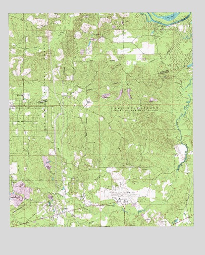
Green Gables, LA USGS Topographic Map
Click on map above to begin viewing in our Map Viewer.

This topographic map contains these locations and features:
Feature Name Type Latitude Longitude GNIS ID View Map
Beaver CreekStreamN31.3921°W92.3335°547043View Map
BobPopulated PlaceN31.4760°W92.2737°545748View Map
Bob ChurchChurchN31.4868°W92.2760°547110View Map
Bragher School (historical)SchoolN31.3893°W92.3551°551677View Map
Bryan PitMineN31.3928°W92.3492°2649862View Map
Camp BeauregardMilitaryN31.4388°W92.2906°2512052View Map
Clear CreekStreamN31.4957°W92.2776°547223View Map
Clear Creek CemeteryCemeteryN31.4696°W92.3429°545755View Map
Clear Creek Lookout Tower (historical)TowerN31.4605°W92.3596°545756View Map
Clear Creek Methodist ChurchChurchN31.4693°W92.3426°554011View Map
Clinton BranchStreamN31.4805°W92.2632°547233View Map
Dry CreekStreamN31.4649°W92.2957°547316View Map
Esler Regional AirportAirportN31.3926°W92.2972°1632595View Map
Green GablesPopulated PlaceN31.3835°W92.3376°547418View Map
Holiday Village Volunteer Fire Department District 4 Station 2BuildingN31.3844°W92.3332°2673145View Map
Lehman LakeLakeN31.4984°W92.2652°555017View Map
Little CreekStreamN31.3821°W92.3096°547599View Map
Lofton CemeteryCemeteryN31.3791°W92.2826°547618View Map
Mill CreekStreamN31.3832°W92.3087°547703View Map
New Zion Church (historical)ChurchN31.3793°W92.2829°551746View Map
Pleasant Grove ChurchChurchN31.3877°W92.3465°547854View Map
Thomas (historical)Populated PlaceN31.4093°W92.3476°551789View Map
Virgin Bend Oil FieldOilfieldN31.4685°W92.2543°551797View Map
Walker LakeLakeN31.4976°W92.2662°556347View Map

Note: Coordinates in the location and feature list above are referenced to NAD83 datum.


Copyright (C) 2008-2025 Ryan Niemi / Sunset Dynamics ... All Rights Reserved