TopoQuest Logo
Do you find TopoQuest useful?
Help keep TopoQuest running and adding new maps/features by donating!
Bitcoin:  19c7KJd3qBynnjoSw5npx9KScwjBe4ifkT
Litecoin:  LXs6TkuXGGXo1vDsWCkWVdjQX94eUKd6ui
Home View Maps Find Maps Find Places Resources & Links


Johnson Shut-ins, Missouri Topographic Map

USGS Map Title: Johnson Shut-ins, MO
USGS Map MRC: 37090E7
DRG (GeoTIFF) Download: o37090e7.tif


Neighboring USGS Topographic Map Quads:


  Johnson Mountain, MO  
37090F8
 

  Banner, MO  
37090F7
 

  Graniteville, MO  
37090F6
 

  Edgehill, MO  
37090E8
 

  Johnson Shut-ins, MO  
37090E7
 

  Ironton, MO  
37090E6
 

  Centerville, MO  
37090D8
 

  Lesterville, MO  
37090D7
 

  Glover, MO  
37090D6


Map MRC Location:

N38°
W91°
N38°
W90°
H8 H7 H6 H5 H4 H3 H2 H1
G8 G7 G6 G5 G4 G3 G2 G1
F8 F7 F6 F5 F4 F3 F2 F1
E8 E7 E6 E5 E4 E3 E2 E1
D8 D7 D6 D5 D4 D3 D2 D1
C8 C7 C6 C5 C4 C3 C2 C1
B8 B7 B6 B5 B4 B3 B2 B1
A8 A7 A6 A5 A4 A3 A2 A1
N37°
W91°
N37°
W90°

Johnson Shut-ins, MO USGS 1:24K Topographic Map Preview:
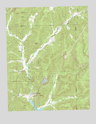
Johnson Shut-ins, MO USGS Topographic Map
Click on map above to begin viewing in our Map Viewer.

This topographic map contains these locations and features:
Feature Name Type Latitude Longitude GNIS ID View Map
Chapman CemeteryCemeteryN37.5889°W90.8462°749330View Map
Church MountainSummitN37.5339°W90.7860°749358View Map
Cope HollowValleyN37.5495°W90.8493°749465View Map
Fitzgerald CemeteryCemeteryN37.5870°W90.8071°749929View Map
Hasty CemeteryCemeteryN37.5814°W90.8551°750251View Map
High Top MountainSummitN37.5803°W90.8337°730439View Map
Imboden ForkStreamN37.5548°W90.8446°750443View Map
Johnson Shut-InsRapidsN37.5394°W90.8381°750535View Map
Johnson's Shut-Ins State ParkParkN37.5373°W90.8504°750536View Map
Lee MountainSummitN37.5067°W90.8515°730438View Map
Lindsey MountainSummitN37.6134°W90.8518°750724View Map
Little Taum Sauk CreekStreamN37.5081°W90.8129°750803View Map
Lower Imboden SchoolSchoolN37.5706°W90.8532°748144View Map
Lower ReservoirReservoirN37.5003°W90.8311°763624View Map
Marys ChapelChurchN37.5800°W90.8518°750954View Map
Middlebrook Development Lake DamDamN37.5717°W90.8685°763820View Map
MontereyPopulated PlaceN37.5720°W90.8532°751140View Map
MungerPopulated PlaceN37.5975°W90.7965°751233View Map
Munger School (historical)SchoolN37.5825°W90.8123°748147View Map
New Hope ChurchChurchN37.6209°W90.8243°751294View Map
Number 49 LakeReservoirN37.5709°W90.8716°763821View Map
Perdido DamDamN37.5950°W90.7785°764880View Map
Pinkley (historical)Populated PlaceN37.5023°W90.8265°739933View Map
Pinkleys School (historical)SchoolN37.5150°W90.8079°748148View Map
Proffit MountainSummitN37.5689°W90.7812°751763View Map
Sawyer SchoolSchoolN37.6123°W90.7735°748146View Map
Shut-in CreekStreamN37.5820°W90.8510°752149View Map
Taum Sauk CemeteryCemeteryN37.5139°W90.8082°752499View Map
Taum Sauk CreekStreamN37.5017°W90.8226°752500View Map
Taum Sauk Nature MuseumBuildingN37.5181°W90.8260°755427View Map
Taum Sauk Pumped-Storage Hydroelectric PowerplantLocaleN37.5206°W90.8346°755428View Map
Taum Sauk Upper DamDamN37.5334°W90.8218°763621View Map
Upper Imboden School (historical)SchoolN37.6228°W90.8229°748143View Map
Upper ReservoirReservoirN37.5358°W90.8188°763622View Map
Walker BranchStreamN37.5103°W90.8404°752729View Map
Walker Branch ChurchChurchN37.5187°W90.8621°752730View Map
Walker Branch School (historical)SchoolN37.5175°W90.8537°748145View Map
Wildcat MountainSummitN37.5681°W90.7546°752895View Map
Womble HollowValleyN37.6134°W90.7743°752965View Map

Note: Coordinates in the location and feature list above are referenced to NAD83 datum.


Copyright (C) 2008-2024 Ryan Niemi / Sunset Dynamics ... All Rights Reserved