TopoQuest Logo
Do you find TopoQuest useful?
Help keep TopoQuest running and adding new maps/features by donating!
Bitcoin:  19c7KJd3qBynnjoSw5npx9KScwjBe4ifkT
Litecoin:  LXs6TkuXGGXo1vDsWCkWVdjQX94eUKd6ui
Home View Maps Find Maps Find Places Resources & Links


Johnson Mountain, Missouri Topographic Map

USGS Map Title: Johnson Mountain, MO
USGS Map MRC: 37090F8
DRG (GeoTIFF) Download: o37090f8.tif


Neighboring USGS Topographic Map Quads:


  Courtois, MO  
37091G1
 

  Palmer, MO  
37090G8
 

  Belgrade, MO  
37090G7
 

  Viburnum East, MO  
37091F1
 

  Johnson Mountain, MO  
37090F8
 

  Banner, MO  
37090F7
 

  Oates, MO  
37091E1
 

  Edgehill, MO  
37090E8
 

  Johnson Shut-ins, MO  
37090E7


Map MRC Location:

N38°
W91°
N38°
W90°
H8 H7 H6 H5 H4 H3 H2 H1
G8 G7 G6 G5 G4 G3 G2 G1
F8 F7 F6 F5 F4 F3 F2 F1
E8 E7 E6 E5 E4 E3 E2 E1
D8 D7 D6 D5 D4 D3 D2 D1
C8 C7 C6 C5 C4 C3 C2 C1
B8 B7 B6 B5 B4 B3 B2 B1
A8 A7 A6 A5 A4 A3 A2 A1
N37°
W91°
N37°
W90°

Johnson Mountain, MO USGS 1:24K Topographic Map Preview:
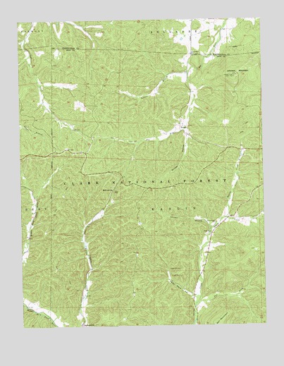
Johnson Mountain, MO USGS Topographic Map
Click on map above to begin viewing in our Map Viewer.

This topographic map contains these locations and features:
Feature Name Type Latitude Longitude GNIS ID View Map
Adams CreekStreamN37.6775°W90.9918°736618View Map
Bells School (historical)SchoolN37.6387°W90.9123°736619View Map
Beulah Land Church (historical)ChurchN37.7439°W90.9618°748135View Map
Chapel Hill BeachBeachN37.7332°W90.9163°754951View Map
Council Bluff ChurchChurchN37.7359°W90.9107°749494View Map
Council Bluff DamDamN37.7300°W90.9085°765493View Map
Council Bluff LakeLakeN37.7268°W90.9176°754383View Map
Council BluffsCliffN37.7361°W90.8975°736858View Map
Cub Creek School (historical)SchoolN37.7148°W90.9871°748136View Map
Enough (historical)Populated PlaceN37.7073°W90.9168°749848View Map
Enough Boat LaunchLocaleN37.7059°W90.9137°753936View Map
Guyser HollowValleyN37.7031°W90.9137°750181View Map
Joes CreekStreamN37.6325°W90.9110°750514View Map
Johnson MountainSummitN37.7267°W90.8890°750534View Map
Kaolin CreekStreamN37.6689°W90.8943°750558View Map
Keith SpringsSpringN37.6802°W90.9523°750567View Map
Keith Springs Picnic AreaLocaleN37.6800°W90.9524°754384View Map
Maxwells MillPopulated PlaceN37.7059°W90.9721°739930View Map
Mitchell Lake DamDamN37.6500°W90.9918°765190View Map
Montana School (historical)SchoolN37.7109°W90.9171°748138View Map
Mountainville StoreLocaleN37.7245°W90.9140°748137View Map
Ottery ChurchChurchN37.6631°W90.9024°751457View Map
Panther BranchStreamN37.6642°W90.9026°751481View Map
Peter Cave HollowValleyN37.6373°W90.9115°751565View Map
RedmondvillePopulated PlaceN37.6256°W90.9693°751837View Map
Redmondville School (historical)SchoolN37.6264°W90.9699°736617View Map
Rencehausen CemeteryCemeteryN37.6670°W90.8996°751852View Map
Sam BranchStreamN37.7050°W90.9154°736616View Map
Shepard (historical)Populated PlaceN37.6964°W90.8871°739932View Map
Smith BranchStreamN37.7212°W90.9115°736615View Map
Sugar Camp BranchStreamN37.7156°W90.9110°736614View Map
Telleck BranchStreamN37.7287°W90.9118°752508View Map
Terry CemeteryCemeteryN37.6384°W90.9676°752515View Map
Township of KaolinCivilN37.6649°W90.8923°766796View Map
Walnut Grove Missionary Baptist ChurchChurchN37.7075°W90.9176°736613View Map
Wild Boar Hollow Boat LaunchLocaleN37.7308°W90.9302°753968View Map
Wild Boar Ridge CampgroundLocaleN37.7267°W90.9274°753935View Map

Note: Coordinates in the location and feature list above are referenced to NAD83 datum.


Copyright (C) 2008-2024 Ryan Niemi / Sunset Dynamics ... All Rights Reserved