TopoQuest Logo
Do you find TopoQuest useful?
Help keep TopoQuest running and adding new maps/features by donating!
Bitcoin:  19c7KJd3qBynnjoSw5npx9KScwjBe4ifkT
Litecoin:  LXs6TkuXGGXo1vDsWCkWVdjQX94eUKd6ui
Home View Maps Find Maps Find Places Resources & Links


Edgehill, Missouri Topographic Map

USGS Map Title: Edgehill, MO
USGS Map MRC: 37090E8
DRG (GeoTIFF) Download: o37090e8.tif


Neighboring USGS Topographic Map Quads:


  Viburnum East, MO  
37091F1
 

  Johnson Mountain, MO  
37090F8
 

  Banner, MO  
37090F7
 

  Oates, MO  
37091E1
 

  Edgehill, MO  
37090E8
 

  Johnson Shut-ins, MO  
37090E7
 

  Corridon, MO  
37091D1
 

  Centerville, MO  
37090D8
 

  Lesterville, MO  
37090D7


Map MRC Location:

N38°
W91°
N38°
W90°
H8 H7 H6 H5 H4 H3 H2 H1
G8 G7 G6 G5 G4 G3 G2 G1
F8 F7 F6 F5 F4 F3 F2 F1
E8 E7 E6 E5 E4 E3 E2 E1
D8 D7 D6 D5 D4 D3 D2 D1
C8 C7 C6 C5 C4 C3 C2 C1
B8 B7 B6 B5 B4 B3 B2 B1
A8 A7 A6 A5 A4 A3 A2 A1
N37°
W91°
N37°
W90°

Edgehill, MO USGS 1:24K Topographic Map Preview:
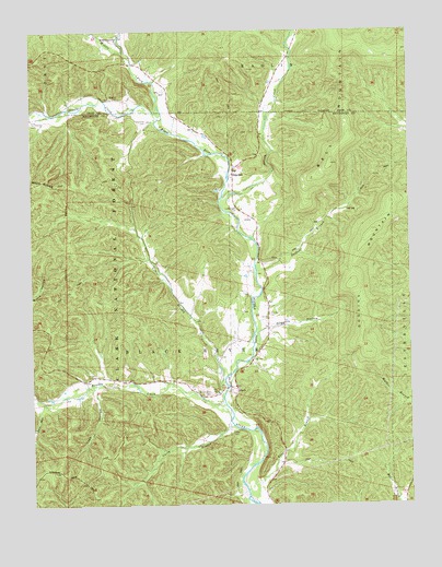
Edgehill, MO USGS Topographic Map
Click on map above to begin viewing in our Map Viewer.

This topographic map contains these locations and features:
Feature Name Type Latitude Longitude GNIS ID View Map
BlackPopulated PlaceN37.5314°W90.9332°748875View Map
Black Post OfficePost OfficeN37.5309°W90.9329°2782992View Map
Black River CemeteryCemeteryN37.5298°W90.9415°748891View Map
Black School (historical)SchoolN37.5298°W90.9390°730436View Map
Brown CemeteryCemeteryN37.5342°W90.9826°749039View Map
Brushy CreekStreamN37.5273°W90.9368°749065View Map
Carty BranchStreamN37.5212°W90.9343°749236View Map
Carty CemeteryCemeteryN37.5189°W90.9348°749237View Map
Cash HollowValleyN37.5306°W90.9798°749244View Map
Clayton CreekStreamN37.6195°W90.9687°749376View Map
EdgehillPopulated PlaceN37.5884°W90.9335°749802View Map
Edgehill School (historical)SchoolN37.5850°W90.9329°730437View Map
Goggins CemeteryCemeteryN37.6075°W90.9707°750059View Map
Goggins HollowValleyN37.5459°W90.9251°750060View Map
Goggins MountainSummitN37.5398°W90.8896°730435View Map
Little Brushy CreekStreamN37.5281°W90.9373°750741View Map
Long BranchStreamN37.5053°W90.9268°750843View Map
Luenbergen CemeteryCemeteryN37.5781°W90.9321°750891View Map
Ottery CreekStreamN37.5809°W90.9373°751458View Map
Padfield BranchStreamN37.5620°W90.9260°751473View Map
Robinett CemeteryCemeteryN37.5503°W90.9215°751913View Map
Strickland CemeteryCemeteryN37.6014°W90.9996°752396View Map
Strother CreekStreamN37.6020°W90.9576°752404View Map
Town HollowValleyN37.5250°W90.9976°752568View Map
Township of Black RiverCivilN37.5469°W90.9838°767276View Map
Troutman CemeteryCemeteryN37.6012°W90.9618°752581View Map

Note: Coordinates in the location and feature list above are referenced to NAD83 datum.


Copyright (C) 2008-2024 Ryan Niemi / Sunset Dynamics ... All Rights Reserved