TopoQuest Logo
Do you find TopoQuest useful?
Help keep TopoQuest running and adding new maps/features by donating!
Bitcoin:  19c7KJd3qBynnjoSw5npx9KScwjBe4ifkT
Litecoin:  LXs6TkuXGGXo1vDsWCkWVdjQX94eUKd6ui
Home View Maps Find Maps Find Places Resources & Links


Jones Knob, Tennessee Topographic Map

USGS Map Title: Jones Knob, TN
USGS Map MRC: 36084B8
DRG (GeoTIFF) Download: o36084b8.tif


Neighboring USGS Topographic Map Quads:


  Wilder, TN  
36085C1
 

  Grimsley, TN  
36084C8
 

  Burrville, TN  
36084C7
 

  Clarkrange, TN  
36085B1
 

  Jones Knob, TN  
36084B8
 

  Twin Bridges, TN  
36084B7
 

  Isoline, TN  
36085A1
 

  Fox Creek, TN  
36084A8
 

  Hebbertsburg, TN  
36084A7


Map MRC Location:

N37°
W85°
N37°
W84°
H8 H7 H6 H5 H4 H3 H2 H1
G8 G7 G6 G5 G4 G3 G2 G1
F8 F7 F6 F5 F4 F3 F2 F1
E8 E7 E6 E5 E4 E3 E2 E1
D8 D7 D6 D5 D4 D3 D2 D1
C8 C7 C6 C5 C4 C3 C2 C1
B8 B7 B6 B5 B4 B3 B2 B1
A8 A7 A6 A5 A4 A3 A2 A1
N36°
W85°
N36°
W84°

Jones Knob, TN USGS 1:24K Topographic Map Preview:
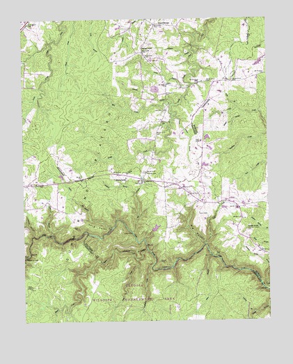
Jones Knob, TN USGS Topographic Map
Click on map above to begin viewing in our Map Viewer.

This topographic map contains these locations and features:
Feature Name Type Latitude Longitude GNIS ID View Map
Adams BranchStreamN36.2103°W84.9213°1275453View Map
Allen BranchStreamN36.1517°W84.9038°1275580View Map
Ashburn FordCrossingN36.1517°W84.9983°1314606View Map
Atkinson BranchStreamN36.2359°W84.9130°1275969View Map
Banner SpringsPopulated PlaceN36.2478°W84.9311°1276268View Map
Beatty School (historical)SchoolN36.2337°W84.9000°1309799View Map
Beetree BranchStreamN36.2115°W84.8866°1276882View Map
Bice CreekStreamN36.1565°W84.9075°1305197View Map
Big BranchStreamN36.1620°W84.9438°1277247View Map
Big HollowValleyN36.1571°W84.9078°1277321View Map
Boiling SpringSpringN36.1845°W84.9477°1277887View Map
Bridge CreekStreamN36.2103°W84.9216°1278344View Map
Burnett DamDamN36.2301°W84.8783°1302433View Map
Burnett LakeReservoirN36.2314°W84.8793°1302432View Map
Carter BranchStreamN36.2223°W84.9141°1279779View Map
Clarkrange Division (historical)CensusN36.2365°W84.9958°1648687View Map
Cold Spring CemeteryCemeteryN36.1398°W84.9986°1306021View Map
Cold Spring School (historical)SchoolN36.1370°W84.9986°1302851View Map
Cold Springs (historical)Populated PlaceN36.1390°W84.9966°1311124View Map
Cross HollowValleyN36.1603°W84.9947°1281701View Map
D O Beaty ChurchChurchN36.2337°W84.9005°1320829View Map
Friends ChapelChurchN36.1681°W84.8894°1646624View Map
Friends Chapel CemeteryCemeteryN36.1684°W84.8894°1646625View Map
Gene Rogers DamDamN36.1634°W84.9333°1302401View Map
Gene Rogers LakeReservoirN36.1635°W84.9326°1302400View Map
Glade BranchStreamN36.1637°W84.9541°1285472View Map
Hall CemeteryCemeteryN36.1698°W84.9102°1286577View Map
Hall FordCrossingN36.1515°W84.9030°1315178View Map
Houston Spring BranchStreamN36.1406°W84.8791°1269655View Map
Howe School (historical)SchoolN36.2331°W84.9005°1320840View Map
Jones CemeteryCemeteryN36.1865°W84.9358°1289746View Map
Jones FordCrossingN36.1615°W84.9438°1315305View Map
Jones KnobSummitN36.1631°W84.8863°1289813View Map
Jones School (historical)SchoolN36.1842°W84.9352°1309772View Map
JonesvillePopulated PlaceN36.1834°W84.9372°1315308View Map
Land of Lakes Catfish Farm DamDamN36.1901°W84.9050°1302418View Map
Land of Lakes Catfish Farm LakeReservoirN36.1896°W84.9070°1302419View Map
Licklog BranchStreamN36.1281°W84.8836°1291250View Map
Long PointCliffN36.1623°W84.9580°1291993View Map
Mill CreekStreamN36.2162°W84.9261°1293828View Map
Myatt CreekStreamN36.1551°W84.9366°1295180View Map
Palm BranchStreamN36.2131°W84.8897°1296689View Map
Peggy PondLakeN36.1839°W84.9694°1297121View Map
Peter BranchStreamN36.1615°W84.9852°1297239View Map
Pine CreekStreamN36.1512°W84.9422°1297521View Map
Ramsey BranchStreamN36.2151°W84.9225°1298885View Map
RoslinPopulated PlaceN36.2231°W84.9258°1315842View Map
Roslin SchoolSchoolN36.2326°W84.9330°1300108View Map
S Thomas Burnett Dam Number TwoDamN36.1951°W84.9050°1302421View Map
S Thomas Burnett Lake Number TwoReservoirN36.1964°W84.9041°1302420View Map
Shepherd BranchStreamN36.1781°W84.9430°1270038View Map
Smith CemeteryCemeteryN36.1498°W84.9305°1270625View Map
Snakeden CreekStreamN36.1484°W84.9338°1303705View Map
Springs ChapelChurchN36.2381°W84.9380°1303777View Map
Springs Chapel CemeteryCemeteryN36.2390°W84.9424°1320851View Map
Turner FordCrossingN36.1476°W84.9244°1314427View Map
Wattenbarger CemeteryCemeteryN36.1259°W84.9699°1318146View Map
Westfelt CemeteryCemeteryN36.2120°W84.9258°1274246View Map

Note: Coordinates in the location and feature list above are referenced to NAD83 datum.


Copyright (C) 2008-2024 Ryan Niemi / Sunset Dynamics ... All Rights Reserved