TopoQuest Logo
Do you find TopoQuest useful?
Help keep TopoQuest running and adding new maps/features by donating!
Bitcoin:  19c7KJd3qBynnjoSw5npx9KScwjBe4ifkT
Litecoin:  LXs6TkuXGGXo1vDsWCkWVdjQX94eUKd6ui
Home View Maps Find Maps Find Places Resources & Links


Isoline, Tennessee Topographic Map

USGS Map Title: Isoline, TN
USGS Map MRC: 36085A1
DRG (GeoTIFF) Download: o36085a1.tif


Neighboring USGS Topographic Map Quads:


  Obey City, TN  
36085B2
 

  Clarkrange, TN  
36085B1
 

  Jones Knob, TN  
36084B8
 

  Campbell Junction, TN  
36085A2
 

  Isoline, TN  
36085A1
 

  Fox Creek, TN  
36084A8
 

  Pleasant Hill, TN  
35085H2
 

  Crossville, TN  
35085H1
 

  Dorton, TN  
35084H8


Map MRC Location:

N37°
W86°
N37°
W85°
H8 H7 H6 H5 H4 H3 H2 H1
G8 G7 G6 G5 G4 G3 G2 G1
F8 F7 F6 F5 F4 F3 F2 F1
E8 E7 E6 E5 E4 E3 E2 E1
D8 D7 D6 D5 D4 D3 D2 D1
C8 C7 C6 C5 C4 C3 C2 C1
B8 B7 B6 B5 B4 B3 B2 B1
A8 A7 A6 A5 A4 A3 A2 A1
N36°
W86°
N36°
W85°

Isoline, TN USGS 1:24K Topographic Map Preview:
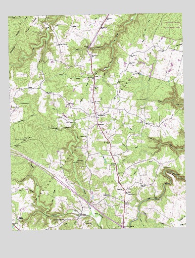
Isoline, TN USGS Topographic Map
Click on map above to begin viewing in our Map Viewer.

This topographic map contains these locations and features:
Feature Name Type Latitude Longitude GNIS ID View Map
Adams Creek DamDamN36.0884°W85.0250°1302355View Map
Adams Creek LakeReservoirN36.0917°W85.0228°1302354View Map
Andrews CemeteryCemeteryN36.0351°W85.0152°1275743View Map
Baker BranchStreamN36.0078°W85.0755°1276145View Map
Bethlehem ChurchChurchN36.0667°W85.0619°1305172View Map
Big HillSummitN36.0528°W85.1152°1277306View Map
BowmanPopulated PlaceN36.0612°W85.0283°1646854View Map
Bowman Census Designated PlaceCensusN36.0586°W85.0305°2586043View Map
Bowman Methodist ChurchChurchN36.0606°W85.0269°1318159View Map
Bowman SchoolSchoolN36.0617°W85.0286°1278080View Map
Braddock CemeteryCemeteryN36.0401°W85.0730°1278144View Map
Brown CemeteryCemeteryN36.0162°W85.0655°1318170View Map
Calvary ChurchChurchN36.0542°W85.0702°1305609View Map
Caney Fork CreekStreamN36.0326°W85.1114°1279574View Map
Carey AirportAirportN36.0670°W85.1219°1301396View Map
Clear Creek ChurchChurchN36.1078°W85.0888°1280665View Map
Coley CreekStreamN36.0590°W85.0819°1306036View Map
Commissioner District 7CivilN36.0806°W85.1015°2464599View Map
Copeland CreekStreamN36.0095°W85.0672°1281246View Map
CrestonPopulated PlaceN36.0087°W85.0752°1281606View Map
Creston Baptist ChurchChurchN36.0103°W85.0752°1318172View Map
Creston CemeteryCemeteryN36.0070°W85.0797°1318173View Map
Crossville-Creston SchoolSchoolN36.0059°W85.0872°1281729View Map
Cumberland County Fire Department Station 7 - 1BuildingN36.1013°W85.0661°2654758View Map
Dickerson CemeteryCemeteryN36.0606°W85.0275°1282434View Map
Dixon CemeteryCemeteryN36.0659°W85.0875°1282519View Map
Downing Creek DamDamN36.0184°W85.0683°1302307View Map
Downing Creek ReservoirReservoirN36.0187°W85.0667°1302306View Map
Drowning CreekStreamN36.0095°W85.0672°1282811View Map
ElmorePopulated PlaceN36.1184°W85.0794°1315017View Map
Elmore CemeteryCemeteryN36.0198°W85.0366°1283719View Map
Frank DamDamN36.0967°W85.0416°1302363View Map
Frank LakeReservoirN36.0961°W85.0416°1302362View Map
Fredonia CemeteryCemeteryN36.0189°W85.0550°1318169View Map
Fredonia ChurchChurchN36.0190°W85.0541°1284867View Map
Goss CemeteryCemeteryN36.0584°W85.0911°1285738View Map
Gould BendBendN36.0306°W85.0108°1285751View Map
Gould CreekStreamN36.0317°W85.0152°1285752View Map
Green Acres CemeteryCemeteryN36.0142°W85.0430°1318168View Map
Hill Lake Number OneReservoirN36.0017°W85.0200°1302288View Map
Hill Lake Number One DamDamN36.0017°W85.0200°1302289View Map
Hughell CrossingLocaleN36.0065°W85.1205°1315273View Map
Hunter MeadowFlatN36.0748°W85.1144°1288748View Map
Interchange 317CrossingN36.0009°W85.0452°1302887View Map
IsolineLocaleN36.0887°W85.0641°1289105View Map
Isoline Baptist ChurchChurchN36.0840°W85.0636°1318158View Map
Lee BranchStreamN36.1115°W85.0966°1290939View Map
Lickfork CreekStreamN36.1067°W85.0516°1291247View Map
Mine BranchStreamN36.0481°W85.0188°1294024View Map
North Crossville AdditionPopulated PlaceN36.0334°W85.0333°1302925View Map
Owens BranchStreamN36.0128°W85.0994°1296570View Map
Parker FordPopulated PlaceN36.0170°W85.0222°1315678View Map
Patton CreekStreamN36.0490°W85.0175°1296979View Map
Pine Grove ChurchChurchN36.0253°W85.0322°1297532View Map
Piney CreekStreamN36.1223°W85.1136°1297626View Map
PlateauPopulated PlaceN36.0828°W85.1114°1297780View Map
Plateau Baptist ChurchChurchN36.0834°W85.1116°1318157View Map
Plateau School (historical)SchoolN36.0823°W85.1116°1318156View Map
Procter CreekStreamN36.0076°W85.0344°1298557View Map
Rocky BranchStreamN36.0084°W85.0341°1299876View Map
Scale CreekStreamN36.0940°W85.0547°1300861View Map
Slatestone BranchStreamN36.0895°W85.0677°1303660View Map
Stephens BranchStreamN36.0223°W85.1058°1271328View Map
TaborPopulated PlaceN36.0223°W85.0430°1646863View Map
Tabor CemeteryCemeteryN36.0267°W85.0833°1272029View Map
Tabor CemeteryCemeteryN36.0389°W85.0763°1272030View Map
Tabor SchoolSchoolN36.0223°W85.0444°1272031View Map
Tankersley LakeReservoirN36.0951°W85.0081°1302358View Map
Tankersley Lake DamDamN36.0934°W85.0083°1302359View Map
Tate CemeteryCemeteryN36.0623°W85.0802°1272151View Map
Terrell BranchStreamN36.0895°W85.0680°1652611View Map
Terrell CemeteryCemeteryN36.0912°W85.0861°1272332View Map
Tollett ChurchChurchN36.0237°W85.0419°1304129View Map
Tolletts Chapel CemeteryCemeteryN36.0234°W85.0416°1318165View Map
Tolletts Chapel School (historical)SchoolN36.0234°W85.0422°1318166View Map
Turner CemeteryCemeteryN36.0028°W85.0680°1273070View Map
Turner Cemetery Number TwoCemeteryN36.0131°W85.0752°1318171View Map
Wallace BranchStreamN36.0012°W85.0047°1273665View Map
White Pine FordCrossingN36.0751°W85.0275°1314502View Map
Winnie CemeteryCemeteryN36.0148°W85.0083°1318167View Map
WoodyPopulated PlaceN36.0667°W85.0638°1302980View Map
Woody CemeteryCemeteryN36.0542°W85.0702°1275108View Map
Woody SchoolSchoolN36.0606°W85.0625°1275109View Map

Note: Coordinates in the location and feature list above are referenced to NAD83 datum.


Copyright (C) 2008-2025 Ryan Niemi / Sunset Dynamics ... All Rights Reserved