TopoQuest Logo
Do you find TopoQuest useful?
Help keep TopoQuest running and adding new maps/features by donating!
Bitcoin:  19c7KJd3qBynnjoSw5npx9KScwjBe4ifkT
Litecoin:  LXs6TkuXGGXo1vDsWCkWVdjQX94eUKd6ui
Home View Maps Find Maps Find Places Resources & Links


Clarkrange, Tennessee Topographic Map

USGS Map Title: Clarkrange, TN
USGS Map MRC: 36085B1
DRG (GeoTIFF) Download: o36085b1.tif


Neighboring USGS Topographic Map Quads:


  Crawford, TN  
36085C2
 

  Wilder, TN  
36085C1
 

  Grimsley, TN  
36084C8
 

  Obey City, TN  
36085B2
 

  Clarkrange, TN  
36085B1
 

  Jones Knob, TN  
36084B8
 

  Campbell Junction, TN  
36085A2
 

  Isoline, TN  
36085A1
 

  Fox Creek, TN  
36084A8


Map MRC Location:

N37°
W86°
N37°
W85°
H8 H7 H6 H5 H4 H3 H2 H1
G8 G7 G6 G5 G4 G3 G2 G1
F8 F7 F6 F5 F4 F3 F2 F1
E8 E7 E6 E5 E4 E3 E2 E1
D8 D7 D6 D5 D4 D3 D2 D1
C8 C7 C6 C5 C4 C3 C2 C1
B8 B7 B6 B5 B4 B3 B2 B1
A8 A7 A6 A5 A4 A3 A2 A1
N36°
W86°
N36°
W85°

Clarkrange, TN USGS 1:24K Topographic Map Preview:
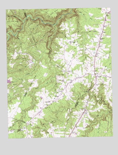
Clarkrange, TN USGS Topographic Map
Click on map above to begin viewing in our Map Viewer.

This topographic map contains these locations and features:
Feature Name Type Latitude Longitude GNIS ID View Map
Balden GulfValleyN36.2442°W85.0568°1276219View Map
Bear BranchStreamN36.2370°W85.0811°1276558View Map
Bear CreekStreamN36.1495°W85.0500°1276596View Map
Big BranchStreamN36.1651°W85.0150°1277248View Map
Camp GroundPopulated PlaceN36.1890°W85.0522°1305625View Map
ClarkrangePopulated PlaceN36.1834°W85.0175°1305941View Map
Clarkrange Baptist ChurchChurchN36.1837°W85.0177°1643385View Map
Clarkrange CemeteryCemeteryN36.1842°W85.0169°1320827View Map
Clarkrange Census Designated PlaceCensusN36.1857°W85.0096°2586045View Map
Clarkrange ChurchChurchN36.2203°W85.0133°1280613View Map
Clarkrange Elementary SchoolSchoolN36.2378°W85.0055°1309770View Map
Clarkrange High SchoolSchoolN36.1828°W85.0183°1309771View Map
Clarkrange Post OfficePost OfficeN36.1856°W85.0281°1650087View Map
Clarkrange United Methodist ChurchChurchN36.1837°W85.0169°1320828View Map
Commissioner District 4CivilN36.2096°W85.0001°2464033View Map
Cooper BranchStreamN36.1856°W85.0669°1306096View Map
D O Beaty BridgeBridgeN36.1698°W85.0286°1281947View Map
Elmore Cemetery Number OneCemeteryN36.1470°W85.0441°1318144View Map
Fentress County Volunteer Fire Department Station 7 ClarkrangeBuildingN36.1934°W85.0208°2654916View Map
Flintrock BranchStreamN36.1651°W85.1208°1284491View Map
Fond BranchStreamN36.1662°W85.1222°1284552View Map
Furry BendBendN36.1642°W85.0366°1285051View Map
Galer BranchStreamN36.1865°W85.0672°1285085View Map
Guffy BranchStreamN36.2270°W85.0672°1286373View Map
Hickory CornerLocaleN36.1387°W85.1000°1317800View Map
How Come You CreekStreamN36.1467°W85.0075°1288520View Map
Hudsonburg (historical)Populated PlaceN36.1334°W85.1152°1310926View Map
Hurricane CreekStreamN36.2342°W85.0680°1288813View Map
Hurricane RidgeRidgeN36.2353°W85.0925°1288838View Map
Jack BranchStreamN36.1987°W85.0936°1289148View Map
Johnson Mill BranchStreamN36.2451°W85.0438°1289644View Map
Key HollowValleyN36.2263°W85.1234°1290128View Map
Little Hurricane CreekStreamN36.2062°W85.0744°1291541View Map
Little Indian CreekStreamN36.2392°W85.1033°1291545View Map
Little Piney CreekStreamN36.1423°W85.1091°1291618View Map
Looper BranchStreamN36.1831°W85.1069°1292057View Map
Lost MountainSummitN36.2259°W85.0933°1292087View Map
Marlow BranchStreamN36.2265°W85.0330°1292709View Map
Martha Washington SchoolSchoolN36.2187°W85.0441°1292785View Map
Maynard HollowValleyN36.2290°W85.1222°1293021View Map
Middle BranchStreamN36.1331°W85.0813°1293650View Map
Morgan BranchStreamN36.2248°W85.1147°1294351View Map
Mount Union CemeteryCemeteryN36.1895°W85.0547°1320844View Map
Mount Union ChurchChurchN36.1898°W85.0552°1294815View Map
Muddy PondPopulated PlaceN36.2084°W85.1127°1315569View Map
Muddy Pond CemeteryCemeteryN36.2067°W85.1063°1644914View Map
Muddy Pond School (historical)SchoolN36.2078°W85.1080°1317270View Map
No Business CreekStreamN36.1509°W85.0005°1295781View Map
North Cumberland Elementary SchoolSchoolN36.1434°W85.0375°1302926View Map
Peachstone Camp HollowValleyN36.2204°W85.1246°1297054View Map
Pine Ridge LakeReservoirN36.1817°W85.1200°1302413View Map
Pine Ridge Lake DamDamN36.1817°W85.1200°1302412View Map
Polk HollowValleyN36.1976°W85.0965°1298061View Map
RinniePopulated PlaceN36.1487°W85.0344°1315809View Map
Rinnie CemeteryCemeteryN36.1514°W85.0330°1318142View Map
Rinnie Freewill Baptist ChurchChurchN36.1517°W85.0327°1318145View Map
Rocky BranchStreamN36.1953°W85.0688°1299865View Map
Slate CreekStreamN36.2465°W85.0472°1270471View Map
Steel Tram RidgeRidgeN36.2367°W85.1222°1303814View Map
The GooseneckBendN36.1615°W85.0138°1272395View Map
Todd HollowValleyN36.1703°W85.0286°1272714View Map
Union B SchoolSchoolN36.1773°W85.1133°1273177View Map
Union Grove SchoolSchoolN36.1523°W85.0330°1304246View Map
Whiteoak BranchStreamN36.2301°W85.0672°1274426View Map

Note: Coordinates in the location and feature list above are referenced to NAD83 datum.


Copyright (C) 2008-2024 Ryan Niemi / Sunset Dynamics ... All Rights Reserved