TopoQuest Logo
Do you find TopoQuest useful?
Help keep TopoQuest running and adding new maps/features by donating!
Bitcoin:  19c7KJd3qBynnjoSw5npx9KScwjBe4ifkT
Litecoin:  LXs6TkuXGGXo1vDsWCkWVdjQX94eUKd6ui
Home View Maps Find Maps Find Places Resources & Links


Fox Creek, Tennessee Topographic Map

USGS Map Title: Fox Creek, TN
USGS Map MRC: 36084A8
DRG (GeoTIFF) Download: o36084a8.tif


Neighboring USGS Topographic Map Quads:


  Clarkrange, TN  
36085B1
 

  Jones Knob, TN  
36084B8
 

  Twin Bridges, TN  
36084B7
 

  Isoline, TN  
36085A1
 

  Fox Creek, TN  
36084A8
 

  Hebbertsburg, TN  
36084A7
 

  Crossville, TN  
35085H1
 

  Dorton, TN  
35084H8
 

  Ozone, TN  
35084H7


Map MRC Location:

N37°
W85°
N37°
W84°
H8 H7 H6 H5 H4 H3 H2 H1
G8 G7 G6 G5 G4 G3 G2 G1
F8 F7 F6 F5 F4 F3 F2 F1
E8 E7 E6 E5 E4 E3 E2 E1
D8 D7 D6 D5 D4 D3 D2 D1
C8 C7 C6 C5 C4 C3 C2 C1
B8 B7 B6 B5 B4 B3 B2 B1
A8 A7 A6 A5 A4 A3 A2 A1
N36°
W85°
N36°
W84°

Fox Creek, TN USGS 1:24K Topographic Map Preview:
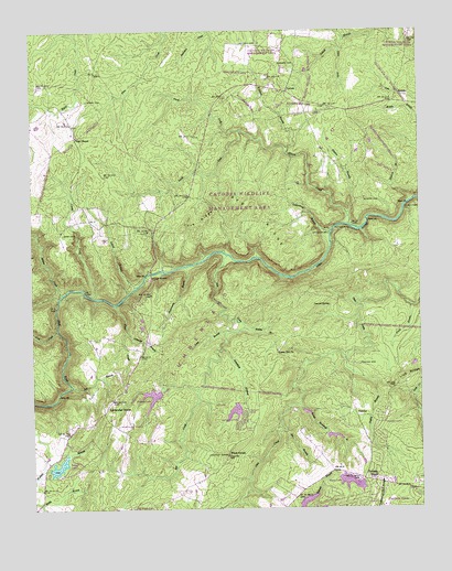
Fox Creek, TN USGS Topographic Map
Click on map above to begin viewing in our Map Viewer.

This topographic map contains these locations and features:
Feature Name Type Latitude Longitude GNIS ID View Map
Adams BridgeBridgeN36.0615°W84.9619°1275455View Map
Adams CreekStreamN36.0559°W84.9905°1275467View Map
Alpine AcresPopulated PlaceN36.1023°W84.9000°1302829View Map
Babcock HollowValleyN36.0278°W84.9941°1302836View Map
Bee BranchStreamN36.0212°W84.9197°1276763View Map
Bee RidgeRidgeN36.0773°W84.9266°1276777View Map
Bob BranchStreamN36.0320°W84.9872°1277858View Map
Brookhart CemeteryCemeteryN36.0223°W84.8944°1318177View Map
Catherine LakeReservoirN36.0084°W84.8933°1302292View Map
Catherine Lake DamDamN36.0084°W84.8933°1302293View Map
Catoosa CanyonPopulated PlaceN36.0487°W84.9666°1302850View Map
Catoosa CountryPopulated PlaceN36.0709°W84.9694°1302849View Map
Cindy CreekStreamN36.0553°W84.9794°1305932View Map
Commissioner District 4CivilN36.0485°W84.9826°2464026View Map
Cove RidgeRidgeN36.0740°W84.9458°1281426View Map
Crossville North Division (historical)CensusN36.0340°W84.9522°1648666View Map
Derrick SpringSpringN36.0531°W84.9041°1282365View Map
Dogleg BranchStreamN36.0387°W84.8988°1306373View Map
Druid HillsPopulated PlaceN36.0023°W84.8772°1302856View Map
Elmore BranchStreamN36.0767°W84.8983°1283717View Map
Elmore CemeteryCemeteryN36.0809°W84.8924°1283720View Map
Elmore CreekStreamN36.0742°W84.8975°1283721View Map
Fairfield GladePopulated PlaceN36.0003°W84.8863°1315036View Map
Fairfield Glade Fire Department Main StationBuildingN36.0059°W84.8850°2654646View Map
Fairfield Glade Post OfficePost OfficeN36.0073°W84.8869°1649067View Map
Flatrock BranchStreamN36.0801°W84.8777°1284438View Map
Forest Hill (historical)Populated PlaceN36.0417°W84.9208°1302863View Map
Forest Hill CemeteryCemeteryN36.0417°W84.9208°1318178View Map
Forest Hill ChurchChurchN36.0415°W84.9211°1284593View Map
Forest Hill School (historical)SchoolN36.0378°W84.8963°1302862View Map
Fox CreekStreamN36.0665°W84.9372°1284774View Map
Fox Creek Lake DamDamN36.0001°W84.9716°1302287View Map
Frances LakeReservoirN36.0293°W84.9616°1284801View Map
Frances Lake DamDamN36.0303°W84.9591°1307179View Map
GenesisPopulated PlaceN36.1092°W84.9172°1315105View Map
Genesis School (historical)SchoolN36.1092°W84.9169°1302866View Map
Good Neighbor LakeReservoirN36.0256°W84.9342°1302314View Map
Good Neighbor Lake DamDamN36.0251°W84.9350°1302315View Map
Goss CemeteryCemeteryN36.0720°W84.9900°1285739View Map
Gulden CemeteryCemeteryN36.1217°W84.9322°1286384View Map
Hanby BranchStreamN36.0478°W84.9316°1286712View Map
Henry CemeteryCemeteryN36.1067°W84.9819°1287439View Map
Henry FordCrossingN36.0781°W84.8800°1315224View Map
Laurel BranchStreamN36.0581°W84.9663°1290699View Map
Lavender BranchStreamN36.0465°W84.9697°1290768View Map
Lavender KnobSummitN36.0262°W84.9766°1290772View Map
Linger LakeReservoirN36.0114°W84.9917°1291338View Map
Linger LakePopulated PlaceN36.0140°W84.9847°1302902View Map
Linger Lake DamDamN36.0106°W84.9947°1307178View Map
Long BranchStreamN36.0465°W84.9377°1291881View Map
Mill Creek (historical)Populated PlaceN36.0726°W84.9902°1311127View Map
Mill Creek School (historical)SchoolN36.0731°W84.9902°1302917View Map
Neal ChapelChurchN36.0973°W84.9852°1295282View Map
North Fork Elmore CreekStreamN36.0987°W84.9330°1295883View Map
PeavinePopulated PlaceN36.0256°W84.8963°1315688View Map
Peavine CemeteryCemeteryN36.0376°W84.8947°1297088View Map
Pilot KnobSummitN36.0140°W84.9375°1297484View Map
Piney BranchStreamN36.0531°W84.8777°1297611View Map
Potter FordCrossingN36.0726°W84.9027°1315771View Map
Rough Mountain BranchStreamN36.0270°W84.9138°1300149View Map
Ryan LakeReservoirN36.0066°W84.8977°1300376View Map
Scantling BranchStreamN36.0415°W84.9391°1300863View Map
Scott CreekStreamN36.0470°W84.9919°1300946View Map
Shiloh Church (historical)ChurchN36.1159°W84.9138°1302962View Map
Shiloh School (historical)SchoolN36.1156°W84.9138°1318183View Map
Shoal CreekStreamN36.0537°W84.9730°1270138View Map
Sims Cemetery Number TwoCemeteryN36.0912°W84.9041°1318181View Map
Slate SpringsPopulated PlaceN36.0315°W84.9705°1311126View Map
Slate Springs Baptist ChurchChurchN36.0309°W84.9705°1318175View Map
Slate Springs CemeteryCemeteryN36.0309°W84.9702°1318176View Map
Slate Springs School (historical)SchoolN36.0306°W84.9708°1302963View Map
South Fork Elmore CreekStreamN36.0987°W84.9330°1270863View Map
Sugarcamp BranchStreamN36.0634°W84.9505°1303905View Map
Three ForkStreamN36.1198°W84.9000°1304092View Map
Turkey KnobSummitN36.0087°W84.8891°1273027View Map
Turner CemeteryCemeteryN36.1162°W84.9149°1273073View Map
Turner Cemetery Number OneCemeteryN36.0187°W84.9913°1318174View Map
Turner Cemetery Number ThreeCemeteryN36.1062°W84.8766°1318179View Map
Underwood BranchStreamN36.0723°W84.9033°1273166View Map
Whitepine BranchStreamN36.0309°W84.9469°1274447View Map
WiltshirePopulated PlaceN36.0237°W84.8875°1302979View Map
Wolfpen BranchStreamN36.0931°W84.9180°1274992View Map
WoodlandsPopulated PlaceN36.0056°W84.9180°1302978View Map

Note: Coordinates in the location and feature list above are referenced to NAD83 datum.


Copyright (C) 2008-2025 Ryan Niemi / Sunset Dynamics ... All Rights Reserved