TopoQuest Logo
Do you find TopoQuest useful?
Help keep TopoQuest running and adding new maps/features by donating!
Bitcoin:  19c7KJd3qBynnjoSw5npx9KScwjBe4ifkT
Litecoin:  LXs6TkuXGGXo1vDsWCkWVdjQX94eUKd6ui
Home View Maps Find Maps Find Places Resources & Links


Jordan Narrows, Utah Topographic Map

USGS Map Title: Jordan Narrows, UT
USGS Map MRC: 40111D8
DRG (GeoTIFF) Download: o40111d8.tif


Neighboring USGS Topographic Map Quads:


  Copperton, UT  
40112E1
 

  Midvale, UT  
40111E8
 

  Draper, UT  
40111E7
 

  Tickville Spring, UT  
40112D1
 

  Jordan Narrows, UT  
40111D8
 

  Lehi, UT  
40111D7
 

  Cedar Fort, UT  
40112C1
 

  Saratoga Springs, UT  
40111C8
 

  Pelican Point, UT  
40111C7


Map MRC Location:

N41°
W112°
N41°
W111°
H8 H7 H6 H5 H4 H3 H2 H1
G8 G7 G6 G5 G4 G3 G2 G1
F8 F7 F6 F5 F4 F3 F2 F1
E8 E7 E6 E5 E4 E3 E2 E1
D8 D7 D6 D5 D4 D3 D2 D1
C8 C7 C6 C5 C4 C3 C2 C1
B8 B7 B6 B5 B4 B3 B2 B1
A8 A7 A6 A5 A4 A3 A2 A1
N40°
W112°
N40°
W111°

Jordan Narrows, UT USGS 1:24K Topographic Map Preview:
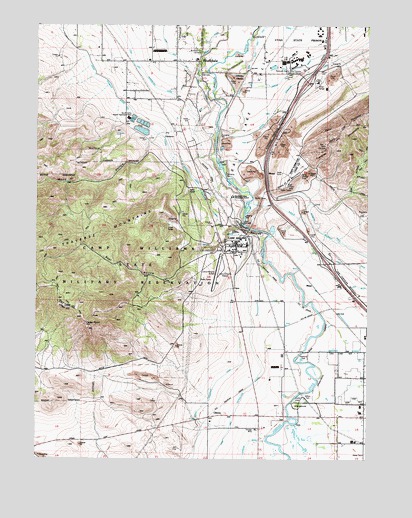
Jordan Narrows, UT USGS Topographic Map
Click on map above to begin viewing in our Map Viewer.

This topographic map contains these locations and features:
Feature Name Type Latitude Longitude GNIS ID View Map
Avalon EstatesPopulated PlaceN40.4833°W111.9441°1453002View Map
Beef HollowValleyN40.4422°W111.9252°1425397View Map
BluffdalePopulated PlaceN40.4897°W111.9388°1425844View Map
Bluffdale City CemeteryCemeteryN40.4927°W111.9383°1435172View Map
Bluffdale Elementary SchoolSchoolN40.4912°W111.9564°2432369View Map
Bluffdale Fire DepartmentBuildingN40.4909°W111.9488°2627334View Map
Camp Williams Airfield (historical)AirportN40.4319°W111.9308°1434585View Map
Camp Williams HeliportAirportN40.4333°W111.9369°1450275View Map
Camp Williams Utah Army National GuardBuildingN40.4340°W111.9270°2730491View Map
Cedar PointSummitN40.4141°W111.9822°1426475View Map
City of BluffdaleCivilN40.4743°W111.9383°2409871View Map
ClintonPopulated PlaceN40.3869°W111.9358°1437526View Map
Country LivingPopulated PlaceN40.4805°W111.9619°1453000View Map
Draper CanalCanalN40.4744°W111.9119°1440547View Map
Gardiner EstatesPopulated PlaceN40.4972°W111.9897°1452997View Map
Genesis Youth CenterBuildingN40.4937°W111.8925°2767334View Map
Interchange 287CrossingN40.4313°W111.8905°2432195View Map
Interchange 291CrossingN40.4840°W111.8988°2432196View Map
Johnson AndersonPopulated PlaceN40.4766°W111.9424°1453005View Map
JordanPopulated PlaceN40.4999°W111.9508°1435791View Map
Jordan NarrowsGapN40.4416°W111.9222°1429247View Map
Jordan Valley Water Purification DamDamN40.4699°W111.9630°1434815View Map
Jordan Valley Water Purification ReservoirReservoirN40.4699°W111.9630°1434814View Map
Lewis EstatesPopulated PlaceN40.4886°W111.9435°1453003View Map
MesaLocaleN40.4252°W111.8963°1430238View Map
MountLocaleN40.4572°W111.9144°1430518View Map
Moyal AndersonPopulated PlaceN40.4866°W111.9405°1453004View Map
NashPopulated PlaceN40.4547°W111.9222°1437648View Map
Oak HollowValleyN40.4411°W111.9105°1444028View Map
OliversPopulated PlaceN40.4844°W111.9233°1437653View Map
Plaza CondominiumsPopulated PlaceN40.4891°W111.9569°1437434View Map
Point of the MountainCapeN40.4536°W111.9105°1431351View Map
RideoutLocaleN40.4866°W111.8905°1431781View Map
Saratoga CanalCanalN40.3925°W111.9202°1432244View Map
Saratoga Springs Unified Fire Department and Emergency Medical ServicesBuildingN40.3831°W111.9398°2627410View Map
South Bluff EstatesPopulated PlaceN40.4791°W111.9508°1453001View Map
State of Utah Lone Peak Fire CenterBuildingN40.4879°W111.8981°2768488View Map
Steep MountainSummitN40.4719°W111.8830°1446124View Map
The Church of Jesus Christ of Latter Day SaintsChurchN40.4902°W111.9013°1437127View Map
The Church of Jesus Christ of Latter Day SaintsChurchN40.4902°W111.9591°1450672View Map
The Church of Jesus Christ of Latter Day SaintsChurchN40.4899°W111.9405°1436823View Map
Traverse MountainsRangeN40.4636°W111.8985°1446706View Map
Unified Fire Authority Fire Station 114BuildingN40.4917°W111.8758°2627222View Map
Utah Lake Distributing CanalCanalN40.4280°W111.8927°1433838View Map
Utah State PrisonBuildingN40.4905°W111.9023°1454550View Map
Utah State Prison HeliportAirportN40.4997°W111.8858°1436564View Map
Utah Veterans Cemetery and Memorial ParkCemeteryN40.4402°W111.9312°2128075View Map
Wood HollowValleyN40.4691°W111.9527°1434450View Map
Wood Hollow RanchettesPopulated PlaceN40.4738°W111.9447°1437435View Map

Note: Coordinates in the location and feature list above are referenced to NAD83 datum.


Copyright (C) 2008-2024 Ryan Niemi / Sunset Dynamics ... All Rights Reserved