TopoQuest Logo
Do you find TopoQuest useful?
Help keep TopoQuest running and adding new maps/features by donating!
Bitcoin:  19c7KJd3qBynnjoSw5npx9KScwjBe4ifkT
Litecoin:  LXs6TkuXGGXo1vDsWCkWVdjQX94eUKd6ui
Home View Maps Find Maps Find Places Resources & Links


Copperton, Utah Topographic Map

USGS Map Title: Copperton, UT
USGS Map MRC: 40112E1
DRG (GeoTIFF) Download: o40112e1.tif


Neighboring USGS Topographic Map Quads:


  Magna, UT  
40112F1
 

  Salt Lake City South, UT  
40111F8
 

  Bingham Canyon, UT  
40112E2
 

  Copperton, UT  
40112E1
 

  Midvale, UT  
40111E8
 

  Lowe Peak, UT  
40112D2
 

  Tickville Spring, UT  
40112D1
 

  Jordan Narrows, UT  
40111D8


Map MRC Location:

N41°
W113°
N41°
W112°
H8 H7 H6 H5 H4 H3 H2 H1
G8 G7 G6 G5 G4 G3 G2 G1
F8 F7 F6 F5 F4 F3 F2 F1
E8 E7 E6 E5 E4 E3 E2 E1
D8 D7 D6 D5 D4 D3 D2 D1
C8 C7 C6 C5 C4 C3 C2 C1
B8 B7 B6 B5 B4 B3 B2 B1
A8 A7 A6 A5 A4 A3 A2 A1
N40°
W113°
N40°
W112°

Copperton, UT USGS 1:24K Topographic Map Preview:
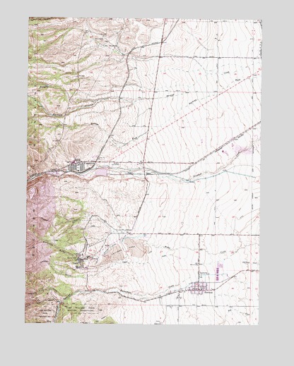
Copperton, UT USGS Topographic Map
Click on map above to begin viewing in our Map Viewer.

This topographic map contains these locations and features:
Feature Name Type Latitude Longitude GNIS ID View Map
Bancroft SpringSpringN40.5971°W112.1153°1425271View Map
Barneys CanyonValleyN40.5922°W112.0597°1425294View Map
Bingham CanyonValleyN40.5627°W112.1041°1425581View Map
Bingham Canyon Post OfficePost OfficeN40.5660°W112.0950°2769090View Map
Bingham City CemeteryCemeteryN40.5655°W112.0805°1437237View Map
Bingham Creek DamDamN40.5599°W112.0824°1434829View Map
Bingham Creek ReservoirReservoirN40.5617°W112.0858°1434828View Map
Bingham DivisionCivilN40.5137°W112.0697°1939349View Map
Bingham Middle SchoolSchoolN40.5661°W112.1008°1425583View Map
Bingham TunnelMineN40.5277°W112.0966°1425584View Map
BP Minerals-Copperton HeliportAirportN40.5666°W112.0911°1450239View Map
Butterfield CanyonValleyN40.5130°W112.0761°1426231View Map
Butterfield CreekStreamN40.5194°W112.0369°1426233View Map
Castro GulchValleyN40.5002°W112.1111°1426394View Map
Cement DitchCanalN40.5141°W112.0438°1426499View Map
City of West JordanCivilN40.6024°W112.0008°2412222View Map
Clay HollowBasinN40.6130°W112.0833°1426687View Map
Copper CreekStreamN40.5272°W112.0435°1426850View Map
Copper GulchValleyN40.5188°W112.0927°1426855View Map
Copper Hills High SchoolSchoolN40.5943°W112.0188°2432604View Map
Copper Hills Youth CenterBuildingN40.5884°W112.0315°2432250View Map
CoppertonPopulated PlaceN40.5647°W112.0974°1426865View Map
Copperton Census Designated PlaceCensusN40.5581°W112.0932°2584760View Map
DaltonPopulated PlaceN40.5611°W112.0605°1437541View Map
Dry CanyonValleyN40.5041°W112.0777°1427520View Map
Fort Herriman Historical MarkerParkN40.5205°W112.0324°1428041View Map
Hayden Peak Elementary SchoolSchoolN40.6053°W112.0139°2432625View Map
HerrimanPopulated PlaceN40.5141°W112.0330°1428675View Map
Herriman CemeteryCemeteryN40.5249°W112.0338°1437240View Map
Hi Country EstatesPopulated PlaceN40.5063°W112.0716°1452227View Map
Immaculate Conception Catholic ChurchChurchN40.5647°W112.1030°1436732View Map
Jordan Hills Elementary SchoolSchoolN40.5899°W112.0064°2432636View Map
Kennecott Eastside Leaching DamDamN40.5644°W112.0824°1434831View Map
Kennecott Eastside Leaching ReservoirReservoirN40.5641°W112.0838°1434830View Map
Keystone GulchValleyN40.5272°W112.0866°1429337View Map
Lark (historical)Populated PlaceN40.5249°W112.0963°1437617View Map
Mascotte TunnelMineN40.5266°W112.0977°1430133View Map
Mascotte Tunnel DitchCanalN40.5324°W112.0772°1430134View Map
Midas GulchValleyN40.5366°W112.0730°1430254View Map
Mountain Shadows Elementary SchoolSchoolN40.6232°W112.0161°2432669View Map
Number 18 AirportAirportN40.5686°W112.0243°2443191View Map
Rivendell of UtahHospitalN40.5933°W112.0313°1436231View Map
RobbePopulated PlaceN40.5611°W112.0705°1437668View Map
Saint Joe TunnelMineN40.5091°W112.1172°1432116View Map
Saint Pauls United Methodist ChurchChurchN40.5624°W112.0961°1436771View Map
Saints Rest GulchValleyN40.5080°W112.1077°1432121View Map
SnyderPopulated PlaceN40.5319°W112.0808°1437687View Map
The Church of Jesus Christ of Latter Day SaintsChurchN40.5624°W112.0966°1436870View Map
The Church of Jesus Christ of Latter Day SaintsChurchN40.5144°W112.0330°1436942View Map
Trinity Community ChurchChurchN40.5099°W112.0661°1450658View Map
Twin KnollsSummitN40.6158°W112.0866°1433738View Map
Unified Fire Authority Fire Station 115 - CoppertonBuildingN40.5659°W112.0933°2627221View Map
Unified Fire Authority Herriman Fire Station 103BuildingN40.5144°W112.0315°2627224View Map
Unified Police Department Herriman PrecinctBuildingN40.5164°W112.0167°2730477View Map
Unified Police Department of Greater Salt Lake - Copperton TownshipBuildingN40.5116°W112.0256°2730483View Map
Unified Police Department of Greater Salt Lake - Herriman CityBuildingN40.5116°W112.0256°2767330View Map
West Hills Middle SchoolSchoolN40.6015°W112.0217°2432595View Map
West Jordan City Fire Department Station 54BuildingN40.5821°W112.0236°2627179View Map
West Jordan City Fire Department Station 55BuildingN40.6102°W112.0439°2627352View Map
Yosemite GulchValleyN40.5111°W112.1036°1434514View Map

Note: Coordinates in the location and feature list above are referenced to NAD83 datum.


Copyright (C) 2008-2025 Ryan Niemi / Sunset Dynamics ... All Rights Reserved