TopoQuest Logo
Do you find TopoQuest useful?
Help keep TopoQuest running and adding new maps/features by donating!
Bitcoin:  19c7KJd3qBynnjoSw5npx9KScwjBe4ifkT
Litecoin:  LXs6TkuXGGXo1vDsWCkWVdjQX94eUKd6ui
Home View Maps Find Maps Find Places Resources & Links


Karthaus, Pennsylvania Topographic Map

USGS Map Title: Karthaus, PA
USGS Map MRC: 41078A1
DRG (GeoTIFF) Download: o41078a1.tif


Neighboring USGS Topographic Map Quads:


  Devils Elbow, PA  
41078B2
 

  Pottersdale, PA  
41078B1
 

  Snow Shoe NW, PA  
41077B8
 

  Frenchville, PA  
41078A2
 

  Karthaus, PA  
41078A1
 

  Snow Shoe, PA  
41077A8
 

  Philipsburg, PA  
40078H2
 

  Black Moshannon, PA  
40078H1
 

  Bear Knob, PA  
40077H8


Map MRC Location:

N42°
W79°
N42°
W78°
H8 H7 H6 H5 H4 H3 H2 H1
G8 G7 G6 G5 G4 G3 G2 G1
F8 F7 F6 F5 F4 F3 F2 F1
E8 E7 E6 E5 E4 E3 E2 E1
D8 D7 D6 D5 D4 D3 D2 D1
C8 C7 C6 C5 C4 C3 C2 C1
B8 B7 B6 B5 B4 B3 B2 B1
A8 A7 A6 A5 A4 A3 A2 A1
N41°
W79°
N41°
W78°

Karthaus, PA USGS 1:24K Topographic Map Preview:
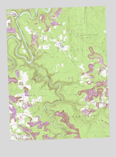
Karthaus, PA USGS Topographic Map
Click on map above to begin viewing in our Map Viewer.

This topographic map contains these locations and features:
Feature Name Type Latitude Longitude GNIS ID View Map
Akely HollowValleyN41.0865°W78.0064°1168104View Map
Ames RunStreamN41.0573°W78.0736°1168261View Map
Belford Number 3 Mine StationLocaleN41.1217°W78.0881°1212781View Map
Big Sterling SpringSpringN41.1006°W78.0450°1202279View Map
Black Moshannon CreekStreamN41.0364°W78.0578°1192150View Map
Boake RunStreamN41.1020°W78.0367°1192173View Map
Confer QuarryMineN41.0686°W78.0189°2724972View Map
Cooper SettlementPopulated PlaceN41.0314°W78.1078°1172424View Map
Crawford RunStreamN41.0303°W78.0806°1172653View Map
Curleys RunStreamN41.1223°W78.1222°1192322View Map
DriftingPopulated PlaceN41.0242°W78.1083°1173479View Map
Drifting Post OfficePost OfficeN41.0154°W78.1216°2773123View Map
German School (historical)SchoolN41.0414°W78.1067°1205483View Map
German SettlementPopulated PlaceN41.0648°W78.0047°1203661View Map
German Settlement School (historical)SchoolN41.0645°W78.0006°1205484View Map
GrassflatPopulated PlaceN41.0026°W78.1145°1175985View Map
Grassflat Census Designated PlaceCensusN41.0031°W78.1113°2630010View Map
Grassflat Volunteer Fire Company Station 19BuildingN41.0134°W78.1227°2645710View Map
KarthausPopulated PlaceN41.1209°W78.1139°1178239View Map
Karthaus Ambulance Service Station 20BuildingN41.1189°W78.1130°2719457View Map
Karthaus Post OfficePost OfficeN41.1200°W78.1163°2772770View Map
Karthaus TunnelTunnelN41.0948°W78.1067°1178240View Map
Karthaus Volunteer Fire Company Station 20BuildingN41.1189°W78.1129°2645703View Map
Laurel RunStreamN41.1198°W78.0964°1178992View Map
Laurel Run School (historical)SchoolN41.0976°W78.0617°1205486View Map
Lower Star School (historical)SchoolN41.1014°W78.0833°1205487View Map
Miles RunStreamN41.0864°W78.0069°1181103View Map
MoshannonPopulated PlaceN41.0323°W78.0050°1181610View Map
Moshannon Census Designated PlaceCensusN41.0344°W78.0067°2584489View Map
Moshannon CreekStreamN41.0728°W78.0975°1192966View Map
Moshannon Post OfficePost OfficeN41.0319°W78.0040°2773215View Map
Moshannon SummitSummitN41.0398°W78.0858°1181611View Map
Mosquito CreekStreamN41.1178°W78.1097°1181617View Map
Mount Carmel Number 2 Mine StationLocaleN41.0776°W78.1222°1212780View Map
Mountain Top Airport (historical)AirportN41.0334°W78.0497°1194159View Map
Old Star SchoolSchoolN41.0684°W78.0370°1205485View Map
Pine GlenPopulated PlaceN41.0889°W78.0567°1183791View Map
Pine Glen Census Designated PlaceCensusN41.0887°W78.0580°2389672View Map
Pine Glen Volunteer Fire Company 17BuildingN41.0924°W78.0589°2645667View Map
Redlick RunStreamN41.0781°W78.0917°1184809View Map
Rock RunStreamN41.0781°W78.1225°1185289View Map
Rupley RunStreamN41.0739°W78.1003°1185624View Map
Saint Severins CemeteryCemeteryN41.0314°W78.1094°1186714View Map
Sevenmile RunStreamN41.0520°W78.0595°1187271View Map
State Game Lands Number 100ParkN41.0967°W78.0214°1188427View Map
Township of CooperCivilN41.0129°W78.1209°1216230View Map
Weber RunStreamN41.0292°W78.0803°1190754View Map

Note: Coordinates in the location and feature list above are referenced to NAD83 datum.


Copyright (C) 2008-2025 Ryan Niemi / Sunset Dynamics ... All Rights Reserved